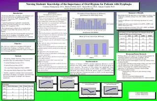
GRAFIIR: Enhanced GOES-R ABI Product Performance Analysis and Validation
The GRAFIIR facility integrates existing and developing capabilities for evaluating data processing and product performance of the GOES-R ABI and assists in assessing instrument impacts on user requirements. By providing a structured approach to validate algorithms through semi-automated comparisons of imagery and derived products, GRAFIIR aims to ensure that the effects of instrument characteristics are accurately accounted for. Utilizing tools like GLANCE, it enhances the efficiency and consistency of analyses, crucial for validating products against other measured datasets and ensuring algorithm performance.

GRAFIIR: Enhanced GOES-R ABI Product Performance Analysis and Validation
E N D
Presentation Transcript
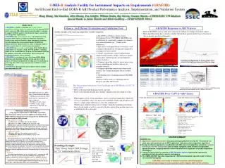
Missing piece GOES-RAnalysis Facility for Instrument Impacts on Requirements (GRAFIIR) An Efficient End-to-End GOES-R ABI Product Performance Analysis, Implementation, and Validation System 8thAnnual Symposium on Future Operational Environmental Satellite Systems, AMS 92st annual meeting, New Orleans, LA, 22-26 January 2012 Hong Zhang, Mat Gunshor, Allen Huang, Eva Schiffer, William Straka, Ray Garcia, Graeme Martin-- CIMSS/SSEC UW-Madison Special thanks to Jaime Daniels and Mitch Goldberg -- STAR/NESDIS NOAA • OBJECTIVE • GRAFIIR is a facility established to leverageexisting capabilities and those under development for both current GOES and its successor ABI in data processing and product evaluation to support GOES-R analysis of instruments impacts on meeting user and product requirements. • GRAFIIR is for “connecting the dots”, the components that have been built and/or are under development, to provide a flexible frame work to effectively adopt component algorithms toward analyzing the sensor measurements with different elements of sensor characteristic (i.e. noise, navigation, band to band co-registration, etc.) and its impact on products. • GRAFIIR is to assess and evaluate many of the GOES-R data and products (i.e. imagery, clouds, derived products, soundings, winds, etc.) in a consistent way to ensure the instrument effects on the products can be fully accounted for, characterized and product performance can be analyzed. • GRAFIIR is a coordinated team effort from GOES-R Risk Reduction and Algorithm Working Group and other related projects. It will not independently develop any new algorithms or processing, but will leverage work already available or under development. • GRAFIIR is a key part of the government’s waiver analysis plan concerning the ABI Glance: An Efficient Evaluation and Validation Tool GRAFIIR Response to ABI Waivers • • Most of GRAFIIR’s waiver tasks are to measure the effects of a change on product output • • Many algorithm teams have a need to validate their product against another type of measured • data to quantify product performance. • GLANCE is a Python software tool in development by the UW-CIMSS GRAFIIR team to efficiently & consistently compare two datasets in a semi-automated way. “Glance at the differences.” • The code is user input driven, so statistics, such as epsilon (threshold) are dynamically changed by user input for each variable. • Glance can generate a report in html format which includes product images, difference images, scatter plots, and histograms; also included are various statistics. • Compare algorithm output to ensure processing system, algorithm and ancillary datasets are installed correctly. • Compare algorithm outputs and obtain useful statistics for varying instrument effect(s)/added noise • Automating time consuming manual GRAFIIR analyses • Glance will be used as a validation tool for Imagery and other AWG teams The Waiver Case: Magnified by 3x and focused on the Texas/Oklahoma border area convection where one of the out-of-spec lines passes through. The Difference: Magnified by 3x, the out-of-spec line is evident in the brightness temperature difference image. ABI Spectral Characteristics Correlation Coefficient is 0.9998 • This Glance report demonstrates Cloud Top Height run on SEVIRI data (12:00 UTC 25 Aug 2006). • File A is the entire full disk processed at one time. • File B is the full disk divided into “chunks” and processed one chunk at a time. “Trouble points” are marked for any pixel in the two output files whose difference exceeds epsilon (which is 500m in this case).anc. • GRAFIIR primarily uses AWG Proxy Team simulated ABI data: • ABI data generated from WRF model analysis performed on a super computer. • Full disk (15-min, 6-km) • CONUS (5-min, 2-km) • Mesoscale (1-min, 667-m) • All 16 bands GRAFIIR Does Cal/Val with Glance Max difference is 0.534 Cloud Top Temperature from ABI cloud algorithm Cloud Top Temperature from WRF What happens when certain algorithms, such as cloud top temperature which rely on n by n uniformity values, are processed in multiple chunks and then processed later as a single chunk (full disk at a time) for comparison? Trouble spots manifest themselves in “stripes” along the beginning and ending lines of each chunk as well as a spread in the data greater than machine precision, as exhibited by the scatter plot. • Modeling of ABI Instrument Effects • (Using Specifications from the ABI PORD, April 2003) • Four instrument effects have been applied to simulated (from WRF) ABI data which have been remapped to an ABI-like grid and quantized for ABI bit depth: • Noise (NEdT or NEdR) • Vis/NIR (bands 1-6): SNR is 300:1 at 100% albedo • IR (bands 7-15): NEdT at 300K is 0.1K, (band 16): 0.3K • Random noise is generated such that for m lines by n elements in an image a random number generator is used on all mXn points where the standard deviation of what will be added to those mXn points is the noise (such as the NEdR equivalent of 0.1K at 300K for IR bands or 300:1 in reflectance units). • Calibration Offset • IR Bands: ABI Spec is for absolute accuracy of 1K • Vis/NIR Bands: ABI Spec is for absolute accuracy of 3% • Navigation Error • Spec Navigation Error is 21 microradians. This spec is the largest of any of the navigation/co-registration type errors. To simulate this error a random compass direction (0-359.99 degrees) is selected for each pixel and a normalized random distribution for distance based on 21 micro radians (0.75km) is added. Then the radiance for that pixel is “smudged” in that direction using linear interpolation. The result is a new image with the original • Lat/Lon grid but slightly altered radiances. A few pixels may have large differences from the original because they were on the edge of a feature such as a cloud. • Striping • The striping specification is “not to exceed the noise”. Assuming the ABI will have a detector array that will result in 100 lines of remapped data, striping is added to one of the first 100 lines and every 100th line after that. • Combination of the above ABI instrument effect: (1X & 3X) • Datasets were created that applied all four instrument effects at 1X spec and 3X spec to determine their effects on certain algorithms. Difference: WRF - ABI • Statistics from Glance: • Numerical Comparison Statistics correlation*: 0.8433 diff_outside_epsilon_count*: 965566 diff_outside_epsilon_fraction*: 1 max_diff*: 98.64 mean_diff*: 12.69 median_diff*: 9.739 mismatch_points_count*: 1359122 mismatch_points_fraction*: 0.4191 perfect_match_count*: 0 perfect_match_fraction*: 0 r-squared correlation*: 0.7112 rms_diff*: 18.97 std_diff*: 14.11 • GRAFIIR SUMMARY • GRAFIIR is to • Implement a facility environment (including leveraging GEOCAT and the AIT “Framework”) to allow easy and consistent use of AWG application team proxy data and product algorithms. • Design an efficient approach in coordination with ABI sensor and algorithm scientists to analyze the effects of sensor components such as noise, navigation, band to band co-registration, optical diffraction, stripping and other effects identified to be significant on product algorithms and imagery. • Assist the government’s response to ABI instrument waivers requested by industry by providing statistical analysis, reports, and imagery. • 4. The CIMSS GRAFIIR Team has responded to 3 ABI waiver/deviation requests to date; 2 others • are currently in progress. • GRAFIIR is now ready to conduct systematic and detail analysis • of ABI instrument impacts on key products and to support ABI Cal/Val activities. Soundings Example “Pure” Proxy Team CONUS image vs “1x” instruments effects Total Precipitable Water (TPW) Spec-level (1x) noise, calibration offset, navigation error, and striping affects TPW, but the algorithm appears robust. Difference Image: Epsilon used here is 0.0