Gray Ghost Ranch Loop Trail Adventure
20 likes | 118 Vues
Explore the scenic Gray Ghost Ranch Loop Trail with stunning views and diverse terrain. Follow detailed directions for a rewarding 31-mile journey through forests and creeks. Enjoy the challenge and beauty of this epic trail run!

Gray Ghost Ranch Loop Trail Adventure
E N D
Presentation Transcript
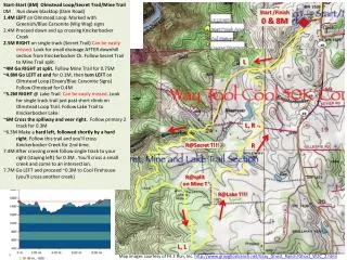
Start-Start (8M) Olmstead Loop/Secret Trail/Mine Trail 0M Run down blacktop (Dam Road) 1.4M LEFT on Olmstead Loop. Marked with Greenish/Blue Carsonite (Wig Wag) signs 2.4M Proceed down and up crossing KnickerbockerCreek 2.5M RIGHT on single track (Secret Trail) Can be easily missed. Look for small drainage AFTER downhill section from KnickerbockerCk. Follow Secret Trail to Mine Trail split. ~4M Go RIGHT at split. Follow Mine Trail for 0.75M ~4.8M Go LEFT at endfor 0.1M, then turn LEFT on Olmstead Loop (Green/Blue Carsonite Signs) Follow Olmstead for 0.4M ~5.2M RIGHT @ Lake Trail. Can be easily missed. Look for single track trail just past short climb on Olmstead Loop Trail. Follow Lake Trail to Knickerbocker Lake. ~6M Cross the spillway and veer right. Follow primary 2 track for 0.3M ~6.3M Make a hard left, followed shortly by a hard right. Follow this trail and you'll cross Knickerbocker Creek for 2nd time. 7.4M After crossing creek follow single track to your right (staying left) for 0.3M . You'll cross a small creek and come to an intersection. 7.7M Go LEFT and proceed ~0.3M to Cool Firehouse (you'll cross another creek) Start /Finish 0 & 8M L L, R R@Secret T!!! R R@split on Mine T R@Lake T!!! L, L Map images courtesy of Fit 2 Run, Inc. http://www.grayghostranch.net/Gray_Ghost_Ranch/Ghost_W2C_2.html
A3->A4 Auburn Lake Trails (4.3M) 16.7M RIGHT @Maine Bar, proceed towards Ball Bearing/ Maine @ base of Ball Bearing. LEFT on “Waterfall/American Canyon Trail”. Follow this for ~1.2M 17.9M Cross creek and proceed uphill. RIGHT or forward at Dead Truck/American Canyon Trail Split. Follow this slightly uphill trail to Hobeken Creek. Continue uphill to Robie Trail. 19.0M RIGHT @ RobieTrail (Brown Carsonite Signs). Follow this trail to ALT Aid ~2 miles Cool: A1 A4 A2 A3 Maine Bar A3: 16.7 M <-4.3M-> Quarry Trail <-5.6M-> Start->A2 Lower Quarry (3.1M) 8.0M From Cool go Counter Clockwise on Olmstead Loop towards Auburn. Follow signs towards Western States Trail (WST) 8.6M LEFT @ WST trail sign (Pointed Rocks Meadow). Follow WST to Lower Quarry/Highway 49 Turn Off ~ 2.3 M. 10.9M Turn RIGHT and cross HW49 A2->A3 Maine Bar (5.6M) 11.1M Follow the Quarry Trail to Maine Bar ~5.6 Miles Auburn Lake Trails A4: 21.0 M Lower Quarry A2: 11.1 M <-5.3M-> A4->A5 Goat Hill (5.3M) 21.0M Continue on Robie Trail ~4.7 miles 25.7M LEFT AFTER foot bridge (still Robie Trail) for 0.3M 26.0M RIGHT(still Robie Trail) UP Goat Hill for ~0.3M Goat Hill A5: 26.3M <-3.4M-> A5->A6 HWY 49 (3.4M) 26.3M Follow RobieTrail Signs to Upper Quarry ~2.5 Miles 28.9M? Upper Quarry > Hwy 49 A6 >FINISH (1.4M) 29.7M Cross HW 49. Follow Robie Trail signs back to Pointed Rocks meadow 30.5M Split off WST and Robie Trail and veer left towards Cool Fire House. 0.6M to Finish A4 A5 A6 Start / Finish <-3.1M-> Hwy 49 A5: 29.7M 0.6M L@WST <-1.4M-> A1/Finish 8M/31.1M Map images courtesy of Fit 2 Run, Inc. http://www.grayghostranch.net/Gray_Ghost_Ranch/Ghost_W2C_2.html