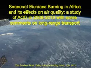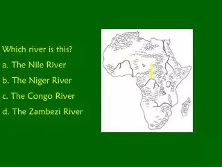
Zambezi River
Zambezi River. By Siobhan Nash. Index. Pg 1 - Title Pg 2 - Index Pg 3 - Map of Africa Pg 4 - Map of the Zambezi river Pg 5 - How long is it and where does it go Pg 6 - Facts about Countries Pg 7 - Facts Continued Pg 8 - Environment Pg 9 - Victoria falls Pg 10 - Victoria falls

Zambezi River
E N D
Presentation Transcript
ZambeziRiver BySiobhanNash
Index • Pg 1 - Title • Pg 2 - Index • Pg 3 - Map of Africa • Pg 4 - Map of the Zambezi river • Pg 5 - How long is it and where does it go • Pg 6 - Facts about Countries • Pg 7 - Facts Continued • Pg 8 - Environment • Pg 9 - Victoria falls • Pg 10 - Victoria falls • Pg 11 - River use • Pg 12 - Surrounding land uses • Pg 13 - Threats and Importance • Pg 14 - Bibliography • Pg 15 - End
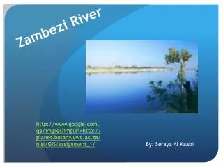
How long is it and where does it go • The river covers 3,540kms and six countries draining an area of some 1,300,000 sq km. It is the fourth largest river system in Africa. • It goes through Zambia, Zimbabwe, Botswana, Mozambique, Angola and Namibia. • It flows out to sea by Mozambique into the Indian Ocean.
Facts about Countries • Zambia is a republic with a population of 11,177,537 (July 1999 est.). Languages: Portuguese (official), Bantu. Lusaka is the capital. Government: democracy • Zimbabwe is 390,580 sq km with a population of 11,477,447 (2007 est.) Harare is the capital of Zimbabwe. Languages: English (official), Shona and Sindabele. Government: democracy • Botswana is 582,000 sq. km. Capital is Gaborone and languages are English (official), Setswana, Ikalanga. Government is a republic, parliamentary democracy.
Facts Continued • Mozambique’s area is 801,590 sq km.The capital is Maputo (pop. 1.2 million--2005 est) the languages are Portuguese (official) and various indigenous languages. Government type: Multi-party democracy. • Angola is 1,246,700 sq. km. Capital is Luanda. Population is 17,000,000. Languages are Portuguese (official) Oshivambo, Afrikaans, German, Herero, Nama/Damara. Government type: Republic. • Namibia Area: 823,145 sq. km. Capital is Windhoek Population is 2.1 million. Languages: English (official); and other languages. Government type: Republic.
Environment • The Zambezi River flows from its headwaters to be joined by the Kabompo River (from northern Zambia) and the Lungue-Bungo River (from central Angola). • The Zambezi flows over a vast inland plateau (Central African Plateau) and sand-covered floodplains - Barotse or Zambezi Plain. The summer floods bring fertile soils. • The Zambezi later goes through the zigzagging gorges and plummets down the Victoria falls. • The Zambezi flows through flat plains in Mozambique before it divides into a wide, flat, and marshy delta where it meets the sea.
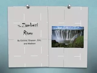
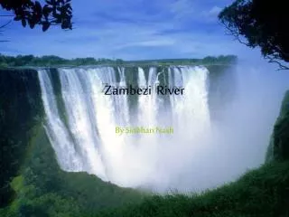
Victoria Falls • The Victoria Falls is 1 708 meters wide, making it the largest curtain of water in the world. It drops between 90m and 107m into the Zambezi Gorge and an average of 550,000 cubic metres of water plummet over the edge every minute. • The Victoria Falls is one of the most spectacular natural wonders of the world. The Local people call it "Mosi-oa-Tunya" -- the smoke that thunders and the Falls are remarkable. • Victoria Falls is a magic place because of the beauty of it, the mist can be seen 40kms away.
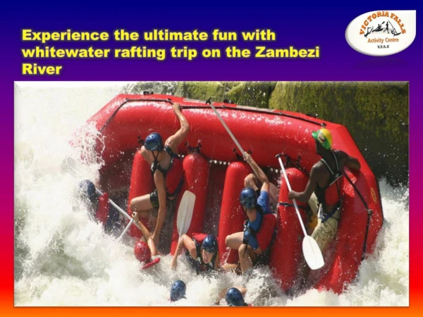
River Use • Drinking water • Irrigation for growing crops • Energy from hydro-electric power (Kariba Dam and Cabora Bassa Dam) • Fishing • Tourism and Recreation – Kayaking, Rafting, canoeing, safaris and bungy jumping. • Supports an abundant wealth of aquatic and animal life some of which are unique to Africa.
Surrounding Land Use • Tourism and recreation – Safaris for hunting or watching animals such as Elephants, Giraffe, Lion and Impala. Abseiling down the gorges. • Subsistence farming – In the middle of the Zambezi river the people grow crops for their own use. • Commercial farming – Near the river in Mozambique Sugar Cane and Cotton are grown for money • National parks – Zambezi and Victoria Falls National Park, Mana Pools National Park and Gonarezhou National Park.
Threats and Importance • Threats to the Zambezi River and area are climate change, poverty, floods, droughts, water pollution and deforestation. • The Zambezi River is very important because it has interesting animals, creates tourism which brings money to the countries and provides many people water, food and electricity.
Bibliography • http://www.google.com.au/imgres?imgurl=http://www.q2travel.co.za/pics/victoria6.jpg&imgrefurl • http://www.zambia-the-african-safari.com/zambezi-river.html • http://www.go2africa.com/zambia/victoria-falls/african-safari-guide/the-zambezi • http://www.nature.org/wherewework/greatrivers/africa/ • http://www.victoriafalls-guide.net/zambezi-river.html • http://zambia-travel.suite101.com/article.cfm/the_mighty_zambezi_river • http://www.zambiatourism.com/travel/places/zambezir.htm • http://wiki.answers.com/Q/What_is_the_capital_city_of_Zimbabwe • http://www.travelblog.org/Africa/Zimbabwe/fact-flag-zimbabwe.html • http://www.questconnect.org/africa_zimbabwe.htm • http://www.infoplease.com/ipa/A0108165.html • http://www.angola.org/ • http://www.state.gov/ • http://planet.botany.uwc.ac.za/NISL/GIS/assignment_1/L_Mosomane_GIS_2006_Assignment_1_cg/Page_06.htm • http://cgee.hamline.edu/rivers/MA2001/MA2000/Guests/archive/keen1.html • http://www.mwebafrica.com/images/plain_map.gif • http://www.riversymposium.com/2004/index.php?element=Tumbare+M • http://www.lydiaw.net/ • "Zambezi River."Encyclopædia Britannica from Encyclopædia Britannica 2006 • http://www.places.co.za/html/vicfalls.html • National geographic October 1997 • Map: Satellite By Philip Eales 2007 • The Macquarie Illustrated World Atlas 1984