Download
1 / 12
120 likes | 341 Vues
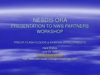
NESDIS ORA PRESENTATION TO NWS PARTNERS WORKSHOP PRECIP, FLASH FLOODS & AVIATION DEVELOPMENTS. Hank Drahos June 24, 2004 Hank.Drahos@noaa.gov http://www.orbit.nesdis.noaa.gov/smcd/index.html. Upcoming Improvements to the Hydro-Estimator on AWIPS.

E N D
NESDIS ORA PRESENTATION TO NWS PARTNERS WORKSHOPPRECIP, FLASH FLOODS & AVIATION DEVELOPMENTS Hank Drahos June 24, 2004 Hank.Drahos@noaa.gov http://www.orbit.nesdis.noaa.gov/smcd/index.html
Upcoming Improvements to the Hydro-Estimator on AWIPS • Currently, the version of the H-E that is supplied to AWIPS uses GOES-12 (East) data only. Beginning with an upcoming AWIPS maintenance release (by the end of FY 2004), GOES-10 (West) data will also be used and will improve coverage and accuracy over the Western US. • Related improvements: • Areas of missing data will be discriminated from areas of no precipitation (currently both are indicated by zero values); • Coverage of the AWIPS product will also be extended into Canada.
Upcoming Improvements to the Hydro-Estimator on AWIPS • In response to an NWS request, a version of the H-E for Hawaii is being developed. Operational implementation is anticipated in FY 2006. • The NWS has also requested H-E coverage over Puerto Rico. Arrangements are being made for coverage to be extended to Puerto Rico in a future AWIPS build (the H-E is already available for Puerto Rico via the Web).
Upcoming Improvements to the Hydro-Estimator on AWIPS • A recalibration of the H-E cloud top temperature/rainfall rate curve has been initiated. • Incorporating lightning data into H-E and the Hydro-Nowcaster.
GOES 12 10.7 mm IR Flash flood producing thunderstorm over the Washington DC Metropolitan Region with 5 minute cloud to ground lightning superimposed: June 17, 2004 at 7:00 PM
Three hour Nowcasts for July 1, 2002, 0600 - 0900 UTC Hydro - Nowcaster [inches] Stage III
Current Capabilities Images (Vis, IR, WV) Fog (11-4mm) Volcanic Ash (11-12mm; GOES-10 only) Sounder products Cloud Top Height Lifted Index Soundings Microburst Indices (Wind Index, MDPI) Potential Upgrades * Low Cloud Base ** Aircraft Icing Ozone (CAT potential) Global cloud tops Volcanic ash (GOES-12 through 15) ** Wet Microburst Potential Index GOES Aviation Products on AWIPS * None on current AWIPS Build schedules ** Supported by NWS
GOES-10 LCB – 27 Aug 2002 / 1300Z http://www.orbit.nesdis.noaa.gov/smcd/opdb/aviation/fog.html GOES Low Cloud Base Product • Shows where low ceilings & fog are likely • Based on GOES IR – surface temperature • Verification (lower 48) • POD ~ 72% • FAR ~ 11% • Low clouds may be obscured by cirrus
< 6 kft < 12 kft < 18 kft < 24 kft GOES ‘ICECAP’ Product http://www.orbit.nesdis.noaa.gov/smcd/opdb/aviation/icg.html GOES Aircraft Icing Potential • Shows likely areas of supercooled clouds + cloud top heights • Uses Imager IR & Visible + Sounder • Not able to detect SLD (Supercooled Large Drop) icing • Cirrus obscuration
U. Of Wisconsin – CIMSS http://cimss.ssec.wisc.edu/goes/realtime/grtmain.html Full Disk Cloud Top Image • Global cloud top coverage • Uses new 13.3 mm IR on GOES-12+ • More accurate cloud top heights for volcanic ash plumes
GOES Ozone Product • High ozone levels are found in tropopause “folds” near upper level fronts • Correlate with clear air turbulence • CIMSS ozone product derived from Sounder CIMSS Ozone Product http://cimss.ssec.wisc.edu/goes/realtime/grtmain.html#ozone