Chapter 2
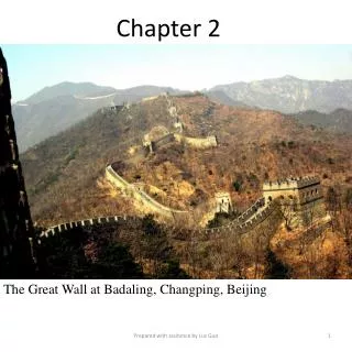
Chapter 2. The Great Wall at Badaling, Changping, Beijing. 2. Spatial and Administrative Divisions. 2.1 Administrative divisions 2.2 Great regions 2.3 Geographical belts 2.4 Southern and northern parts 2.5 Ethno-culture areas. Keywords :. spatial administration, provincial economy,

Chapter 2
E N D
Presentation Transcript
Chapter 2 The Great Wall at Badaling, Changping, Beijing Prepared with assitance by Luc Guo
2. Spatial and Administrative Divisions 2.1 Administrative divisions 2.2 Great regions 2.3 Geographical belts 2.4 Southern and northern parts 2.5 Ethno-culture areas Prepared with assistance by Luc Guo
Keywords: • spatial administration, • provincial economy, • administrative division, • great region, • Eastern/Central/Western belt, • coastal/inland area, • Northern/Southern part, • culture area Prepared with assitance by Luc Guo
2.1 Administrative divisions 2.1.1 Historical evolution 2.1.2 China’s administrative hierarchy 2.1.3 Large versus small administrations 2.1.4 How many provinces should be there in China? Prepared with assistance by Luc Guo
Names of provincial divisions • jun in the Qin dynasty (221–206 BC), • junguo in the Western Han dynasty (206 BC–AD 25), • zhou in the Eastern Han (AD 25–220) and the Wei (AD 220–265), the Jin (AD 266–420) and the North and South (AD 420–589) dynasties, • dao in the Tang dynasty (AD 618–907), • lu in the North and South Song (AD 960–1279) and the Jin (AD 1115–1235) dynasties, • zhongshu-xingsheng in the Yuan dynasty (AD 1279–1368), • xingsheng in the Ming (AD 1368–1644) and the Qing (AD 1644–1911) dynasties. Prepared with assitance by Luc Guo
Table 2.1 Names of various hierarchies of administrative divisions in China Notes: (1) “Sub-provincial-level” (fu shengji) administrative divisions are included in the “Prefectural level” administrative divisions. (2) Hong Kong and Macau are not included. Prepared with assitance by Luc Guo
Table 2.2 Status of China’s current provincial administrations (See next page) Prepared with assitance by Luc Guo
Table 2.2 (Cont’d) Prepared with assitance by Luc Guo
Sources of benefits for large administrations: • The large administrations can make relatively efficient use of their fixed cost and hence gain considerable advantages over small administrations. • Marketing in a larger economy has many benefits, but the main economies of scale from marketing include the bulk purchases and distribution potentialities. Prepared with assitance by Luc Guo
Figure 2.1 The optimum size (S*) of administrative divisions Prepared with assitance by Luc Guo
2.2 Great regions 2.2.1 Historical evolution 2.2.2 Statistical and economic regions Prepared with assitance by Luc Guo
The six great regions: • Huabei (North) region (including Beijing, Tianjin, Hebei, Shanxi, and Inner Mongolia). • Dongbei (Northeast) region (including Liaoning, Jilin, and Heilongjiang). • Huadong (East) region (including Shanghai, Jiangsu, Zhejiang, Anhui, Fujian, Jiangxi, and Shandong). • Zhongnan (Central South) region (including Henan, Hubei, Hunan, Guangdong, Guangxi, and Hainan). • Xi’nan (Southwest) region (including Sichuan, Chongqing, Guizhou, Yunnan, and). • Xibei (Northwest) region (including Shaanxi, Gansu, Qinghai, Ningxia, and Xinjiang). Prepared with assitance by Luc Guo
Figure 2.2 The six great regions Prepared with assitance by Luc Guo
China’s three major economic engines: • The Bohai Sea rim (BSR) area (including Beijing, Tianjin, the coastal Hebei, and the peninsulas of Shandong and Liaodong), • The Pearl river delta (PRD) area (including Guangdong, and northern Hainan, Hong Kong and Macau), and • The Yangtze river delta (YRD) area (including Shanghai, Zhejiang, and southern Jiangsu). Prepared with assitance by Luc Guo
Table 2.3 China’s three economic engines (areas) Prepared with assitance by Luc Guo
2.3 Geographical belts 2.3.1 Coastal and inland areas 2.3.2 Eastern, central and western belts Prepared with assitance by Luc Guo
China’s geographical belts: • Eastern belt (including Liaoning, Hebei, Beijing, Tianjin, Shandong, Jiangsu, Shanghai, Zhejiang, Fujian, Guangdong, Hainan, and Guangxi, with 13.5 percent of the land area). • Central belt (including Shanxi, Jilin, Heilongjiang, Anhui, Henan, Hubei, Hunan, Jiangxi, and Inner Mongolia, with 29.8 percent of the land area). • Western belt (including Sichuan, Chongqing, Guizhou, Yunnan, Shaanxi, Gansu, Qinghai, Tibet, Ningxia, and Xinjiang, with 56.7 percent of the land area). Prepared with assitance by Luc Guo
Figure 2.3 The coastal/inland areas and the Eastern/Central/Western belts Prepared with assitance by Luc Guo
2.4 Southern and northern parts 2.4.1 Natural and social contexts 2.4.2 Criteria for the bi-national division Prepared with assitance by Luc Guo
Figure 2.4 The Northern and Southern parts Prepared with assitance by Luc Guo
Northern and Southern China: • Northern part (including Beijing, Tianjin, Hebei, Shanxi, Inner Mongolia, Liaoning, Jilin, Heilongjiang, Shaanxi, Gansu, Qinghai, Ningxia, Xinjiang, Shandong, and Henan, with 59.8 percent of the land area). • Southern belt (including Shanghai, Jiangsu, Zhejiang, Anhui, Fujian, Jiangxi, Sichuan, Chongqing, Guizhou, Yunnan, Tibet, Hubei, Hunan, Guangdong, Guangxi, and Hainan, with 40.2 percent of the land area). Prepared with assitance by Luc Guo
2.5 Ethno-culture areas 2.5.1 Historical evolution 2.5.2 Organization Prepared with assitance by Luc Guo
Figure 2.5 The ethno-culture areas Prepared with assitance by Luc Guo
Five autonomous regions: • Guangxi Zhuang autonomous region • Inner Mongolia autonomous region • Ningxia Hui autonomous region • Tibet autonomous region • Xinjiang Uygur autonomous region Prepared with assitance by Luc Guo
30 autonomous prefectures (APs) in nine provincial administrations: • Gansu province: Gannan Tibetan AP; Linxia Hui AP. • Guizou province: Qiandongnan Miao-Dong AP; Qiannan Buyi-Miao AP; Qianxi‘nan Buyi-Miao AP. • Hubei province: Enshi Tujia-Miao AP. • Hunan province: Xiangxi Tujia-Miao AP. • Jilin province: Yanbian Korean AP. • Qinghai province: Yushu Tibetan AP; Hainan Tibetan AP; Huangnan Tibetan AP; Haibei Tibetan AP; Guoluo Tibetan AP; Haixi Mongolian-Tibetan AP. • Sichuan province: Ganzi Tibetan AP; Liangshan Yi AP; A‘ba Tibetan-Qiang AP. • Xinjiang Uygur autonomous region: Bayin‘guole Mongolian AP; Bo‘ertala Mongolian AP; Kezilesu Kirgiz AP; Changji Hui AP; Yili Kazak AP. • Yunnan province: Xishuangbanna Dai AP; Dehong Dai-Jingpo AP; Nujiang Lisu; Dali Bai AP; Diqing Tibetan AP; Honghe Hani-Yi AP; Wenshan Zhuang-Miao AP; Chuxiong Yi AP. Prepared with assitance by Luc Guo
Case study 2 Who owns Lake Weishan? The full version of this research is available at: http://www.elsevierdirect.com/companions/9780123978264 Prepared with assitance by Luc Guo
Figure 2.6 The differently defined borders between Shandong and Jiangsu provinces Prepared with assitance by Luc Guo
Chapter conclusion: The Chinese economy is one of the most complicated and diversified spatial systems to be found anywhere in the world. The only feasible approach one can adopt is, therefore, to divide it into smaller geographic elements through which one can gain a better insight into the spatial mechanisms and regional characteristics. It is common for the spatial division of the Chinese economy to differ, depending on the analytical purposes. Prepared with assitance by Luc Guo
Suggested reading (For news and information about China’s provincial and local administrations, please visit the official websites of the 31 provincial governments, shown in the last column in Table 2.2). Alesina, A., E. Spolaore, and R. Wacziarg (2000). “Economic integration and political disintegration,” American Economic Review, Volume 90, pp. 1276–96. Bolton, P., and E. Spolaore (1996). “ Economic Theories of Integration and Break-up of Nations,” European Economic Review, Volume 81, pp. 697-705. Bolton, P., and G. Roland (1997). “The Breakup of Nations: A Political Economy Analysis,” The Quarterly Journal of Economics, Volume 112, pp. 1057-89. Prepared with assitance by Luc Guo
Suggested reading Chung, J.H. and T-C Lam (eds., 2010). China’s Local Administration: Traditions and Changes in the Sub-national Hierarchy, London and New York: Routledge. Friedman, D. (1977). “A Theory of the Size and Shape of Nations,” Journal of Political Economy, Volume 85(1), pp. 59-77. Gordon, Roger H. and Wei Li (2011). “Provincial and Local Governments in China: Fiscal Institutions and Government Behavior,” NBER Working Paper No. 16694, January. Goyal, S. and K. Staal (2003). “The political economy of regionalism,” European Economic Review, Volume 48, pp. 563-93. Guo, Rongxing (2012). “Interprovincial Border Disputes: The Case of Lake Weishan,” Journal of Contemporary China, Volume 21, Issue 57, June, pp. 1-20. Prepared with assitance by Luc Guo