Comparative Analysis of Satellite-Based Nowcasting Algorithms in New York City Area
This study compares satellite-based nowcasting algorithms for convective precipitation in New York City. By analyzing different algorithms like RDT and HE, the research aims to enhance forecasting accuracy and economic value. Comparison involves leveraging satellite data to overcome limitations of NWP models and radar systems. Implementing elements from the European SAFNWC and NOAA, the study seeks to optimize nowcasting models for improved real-time weather predictions. Results from this research can contribute to advancements in short-term weather forecasting techniques.

Comparative Analysis of Satellite-Based Nowcasting Algorithms in New York City Area
E N D
Presentation Transcript
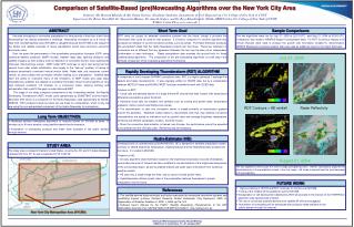
Comparison of Satellite-Based (pre)Nowcasting Algorithms over the New York City Area Students: Mr. Bernard.Mhando & Ms. Nasim Nourozi (Graduate Students),Department of Civil Engineering, City College of New York at CUNY Supervisors:Dr. Brian Vant-Hull, Dr. Shayesteh Mahani, Dr. Arnold Gruber, and Dr. Reza Khanbilvardi, NOAA-CREST at the City College of New York of CUNY E-Mail: brianvh@ce.ccny.cuny.edu Short Term Goal ABSTRACT Sample Comparisons RDT does not project its detected convective systems into the future, though it provides the information that could be used for that purpose. It is best to compare it to another algorithm that produces an indicator of current convective activity, such as rainfall. The Hydro-Estimator produces the precipitation fields that the Hydro-Nowcaster projects into the future. These two indicators of convection are so different that any agreement between the two may be seen as an independent confirmation of each technique. Radar precipitation data provides the ground truth for these satellite based algorithms. This comparison of the ‘pre-nowcasting’ algorithms is a vital step in the ultimate comparison of the nowcasting algorithms themselves. Accurate forecasting of convective precipitation for time periods of less than a few hours (Nowcasting) has always presented a challenge. Nowcasting (forecasts up to 6 hours) in New York City Metropolitan area (NYCMA) is valuable because the NYCMA is the largest in the Nation and reliable nowcasts of heavy precipitation would have enormous economic and social value. Over the years the performance of the quantitative precipitation forecasts (QPF) using numerical weather prediction (NWP) models, weather radar data, lightning detectors and satellite imagery as their primary tools for detection of convective storms, have significantly improved. Shortcomings remain: NWP model QPF continues to lag in skill during the first several hours after model initialization, due largely to the “spin-up” problem of having to produce dynamically consistent vertical motion fields. Radar data only measures current rainfall, so cannot detect the convective initiation leading up to precipitation. Satellite data have the ability to overcome many of the limitations of NWP model and radar data. Geostationary satellites are capable of providing information about cloud properties at very high temporal resolution (15 minutes) on a continuous basis, allowing tracking and extrapolation that could fill the gaps in radar data and NWP. This stage of our study compares components of two nowcasting models: the Rapidly Developing Thunderstorm (RDT) model used operationally by EUMETSAT, and the Hydro-Estimator (HE) which is a component of the Hydro-Nowcaster used operationally by NOAA-NESDIS. RDT produces trends but does not use these for extrapolation, which is why we are using the non-extrapolated component of the Hydro-Nowcaster for comparison. The two algorithms were run for July 27, 2005 at 22:15 UTC, and Aug 21, 2004 at 02:00 UTC. Comparison was made to NEXRAD Stage IV precipitation data. For RDT 3 previous images at 30 minute intervals were used to produce the growth rate information needed for discrimination. NESDIS Reanalysis numerical weather data was used as additional input for the Hydro-Estimator. July 27, 2005 Rapidly Developing Thurnderstorm (RDT) ALGORITHM • A component of the European SAFNWC operational suite, RDT is a highly optimized C package that detects and tracks thunderstorms. It was originally written for SEVIRI data, but by a collaboration between METEO-France and NOAA/CREST has been modified to work with GOES data. • Features of RDT: • Cloud cells are detected based on a single thermal IR channel that finds ‘towers’ with temperature differences exceeding a given threshold. • Individual cloud cells are tracked, and statistics such as cooling and growth rates, temperature gradients, motion vectors and lifetimes are stored. • The discrimination of cells into convective storms is based primarily on temperature gradient around the periphery. Statistical lookup tables to discriminate cells that may develop convective characteristics are based on indicators such as growth rates and average brightness temperature, binned by cell lifetime, geographic location, and time of year. • Since the convective discrimination is trained over Europe, the performance cannot be expected to be optimal over the US East coast. Retraining may be necessary. RDT Contours + HE rainfall Radar Reflectivity Long Term OBJECTIVES • Modifying existing nowcasting algorithms to nowcast rainfall for NYCMA at every 15 minutes up to 6 hours duration using satellite-based cloud information. • Automation of nowcasting products and make them available to the public domain through internet Hydro-Estimator (HE) • Developed and run operationally by NOAA/NESDIS, HE is designed to estimate precipitation based primarily on GOES brightness temperature, creating features that the HydroNowcaster projects into the future. It is coded in MCIDAS. • Features of HE: • An early algorithm (Auto-Estimator) based on the brightness temperature of pixels immediately surrounding the point of interest has been modified to include statistics of the brightness temperature of the surrounding region, as well as stability indices and water vapor information from numerical weather models. • HE uses only a single image at a time, and so cannot include growth rates. • HydroNowcaster utilizes growth rates of the precipitation features themselves to project precipitation into the future. STUDY AREA The study area is located in Eastern United States, covering NJ, NY and CT states Between Latitudes 36º N to 47º N, and Longitudes 67º W to 82º W. August 21, 2004 The two algorithms tend to pick the same strongly precipitating cores. Neither satisfactorily captures the frontal behavior of the precipitation shown in the July image. HE tends to overestimate the areal coverage of the precipitation, FUTURE WORK • Vigorous testing of HE/HN and RDT continues for storms over NYCMA. • Tuning of the models will be applied to suit the NYCMA. • Extrapolation of cell development detected by RDT will proceed in the manner of the FORTRACC algorithm used operationally in Brazil. • The use of convective potential derived from satellite IR will be investigated. • Automation of nowcasting will be developed with products made available to the public domain through the internet. References • The satellite-derived hydro-estimator and hydro-nowcaster for mesoscale convective systems and landfalling tropical systems, Scofield, Roderick; Robert Kulikowski, Clay Davenport: 2005. In Applications of Weather Satellites II, SPIE, v. 5658, pp116-124. • Software User’s Manual for the PGE11: Rapidly Developing Thunderstorms of the SAF NWC/MSG: Scientific Part.SAFSAF/NWC/IOP/MFT/SCI/SUM/11, http://safnwc.imn.es. New York City Metropolitan Area (NYCMA) American Meteorological Society Annual Meeting GOES User’s Conference, 15 –21 January 2007