Download
1 / 20
200 likes | 314 Vues
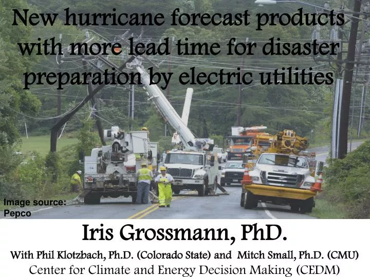
New hurricane forecast products with more lead time for disaster preparation by electric utilities. Iris Grossmann, PhD. With Phil Klotzbach, Ph.D. (Colorado State) and Mitch Small, Ph.D. (CMU) Center for Climate and Energy Decision Making (CEDM). Image source: Pepco.

E N D
New hurricane forecast products with more lead time for disaster preparation by electric utilities Iris Grossmann, PhD. With Phil Klotzbach, Ph.D. (Colorado State) and Mitch Small, Ph.D. (CMU) Center for Climate and Energy Decision Making (CEDM) Image source: Pepco
Motivation: Tropical cyclones (TC) may become more intense in a warmer world…. 2 Center for Climate and Energy Decision Making
2008 Hurricane season: 7 TC landfalls in US,40 million customers experienced outages Cat 1 Kyle TS Edouard TS Hanna Cat 2 Gustav Cat 2 Ike TS Fay Cat 1 Dolly Image source: NOAA/NHC 3
Utility preparation prior to expected TC landfall • Assess needs for line & tree crews and equipment • Request crews through mutual assistance groups • Ready crews; plan transportation, lodging etc • Deploy crews • Revise... Problems: • Preparation is expensive • Need to prepare well in advance, e.g., at least 3 days, but forecasts at that time are not very good. Center for Climate and Energy Decision Making
How good are hurricane track forecasts? 130-255m error Image source: NOAA/NHC 5 Center for Climate and Energy Decision Making
Very intense storms may change intensity too quickly for accurate forecasting Cat 5 Cat 4 Cat 3 Hurricane Opal 1995 Cat 2 Cat 1 Cat 5 Cat 4 Cat 3 Cat 2 Cat 1 Hurricane Felix 2007 Image source: NOAA/NHC 6 Center for Climate and Energy Decision Making
2-phase approach to TC forecasting & power restoration(project in review with NSF Infrastructure Management & Extreme Events) • New statistical TC forecasting scheme • Dynamic programming model for power line restoration planning Center for Climate and Energy Decision Making
2-phase approach to TC forecasting & power restoration(project in review with NSF Infrastructure Management & Extreme Events) • New statistical 5-14 day TC forecasting scheme • Assess probability that TC will undergo rapid intensification (RI) and probability that it will become long-lasting major TC • Assess likelihood ranges for landfall locations, using historic tracks in proximity to given TC, analog years, and prevailing tracking patterns during given season • Dynamic programming model for restoration planning • Successive evaluation of optimal allocation / deployment • In each step: should crews stay or move? • Compare cost across 4 options below:
Forecast scheme makes use of conditions that determine TC formation and intensity • Thermal energy from difference between warm ocean and colder atmosphere • Unstable atmosphere • Mid-tropospheric moisture • Low vertical wind shear • Vorticity (spin) • Coriolis force Image source: Wikipedia Center for Climate and Energy Decision Making
Early stage storms: “invests” Bottom: fully formed hurricane Image sources: NOAA/NHC, NASA Center for Climate and Energy Decision Making
Preliminary studies till date (in collaboration with forecaster Phil Klotzbach) • Pilot-study: scheme to evaluate potential for TC formation • Assess probability that an invest will spend „long“ time period in major TC stage • Assess probability of rapid intensification (RI) • Tracking patterns and analog years Center for Climate and Energy Decision Making
I. Pilot study on TC formation forecasting scheme MDR Genesis Parameter (10-20°N, 20-60°W) Center for Climate and Energy Decision Making
I. Pre-cursor signals for TC formation(from Phil Klotzbach) 9 – 11 Day Lead 6 – 8 Day Lead 3 - 5 Day Lead 0 - 2 Day Lead
II. Assess probability that invest will spend “long” time period in major TC status Conditions at time of initial TC formation for soon-to-be major hurricanes vs weaker storms • 56% less wind shearthan non-developing invests, 44% less than all hurricanes. • 16.5% more humidity than non-developing invests, 3% more than all hurricanes. • 1.6K warmer sea surface temperature than for non-developing invests, 0.8K warmer than for all hurricanes. Center for Climate and Energy Decision Making
Relationship between duration in major TC status and damages 40% of hurricanes that spend at least 36 hours in major hurricane status cause ≥ $1 billion in (normalized) US damages. Center for Climate and Energy Decision Making
III. Assess probability of rapid intensification by MJO phase during TC formation • The MJO(Madden Julian Oscillation) is a large-scale pattern of variability on the 30-90 day scale. • It is not free-standing but travels eastward as an atmospheric wave. • It progresses through 8 phases. Probability of RI by MJO phase during which TC formed Center for Climate and Energy Decision Making
IV. Steering patterns: pattern persistence 1951 2004 Image source: NOAA/NHC
IV. Steering patterns: pattern persistence (2) 2010 1954 Image source: NOAA/NHC
Other climate work that I am engaged in • Decision-analysis of hurricane modification (completed) • Assessing and communicating non-stationary hurricane return periods given multidecadal variability and global warming (project in review at NSF Earth System Models) • Assessment of hurricane risks to off-shore wind turbines (published in PNAS) • Assessment of changes in US Southwest drought risks • “Force majeure“ – due to climate change, climate hazards may no longer be classifiable as act of God • Evaluation of solar insolation data for large-scale solar networks (in review at Renewable & Sustainable Energy Reviews) Center for Climate and Energy Decision Making
Thank you for your attention Center for Climate and Energy Decision Making