1 / 38

SYR NAS SURVEY 01/23/2013

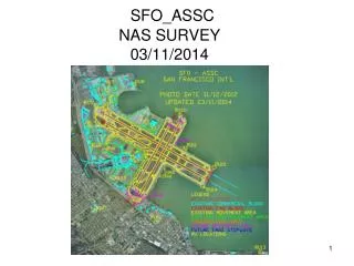
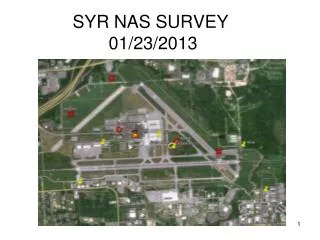
SYR NAS SURVEY 01/23/2013. Proposed SAR RU Locations. CONTACTS. NAS ENG: Gail Evans: Survey Team (405) 954-9834 c(405) 826-2667 Walter Meyer: Survey Team (405) 954-2820 c(405) 590-5050 Devlan Maxwell: Sys Eng Team Lead (405) 954-1174 SYR FAA:

liz
Télécharger la présentation

SYR NAS SURVEY 01/23/2013

An Image/Link below is provided (as is) to download presentation Download Policy: Content on the Website is provided to you AS IS for your information and personal use and may not be sold / licensed / shared on other websites without getting consent from its author. Content is provided to you AS IS for your information and personal use only. Download presentation by click this link. While downloading, if for some reason you are not able to download a presentation, the publisher may have deleted the file from their server. During download, if you can't get a presentation, the file might be deleted by the publisher.

E N D

Presentation Transcript


  1. SYR NAS SURVEY 01/23/2013

  2. Proposed SAR RU Locations

  3. CONTACTS NAS ENG: • Gail Evans: Survey Team (405) 954-9834 c(405) 826-2667 • Walter Meyer: Survey Team (405) 954-2820 c(405) 590-5050 • Devlan Maxwell: Sys Eng Team Lead (405) 954-1174 SYR FAA: • Tech OPS: Bill Campbell SENSIS: • Dave Olster: Sys Eng Air Traffic Sys(508) 881-6181 c(315) 382-4157 • Bill Athey: (315) 416-4578 • Glenn Hall: Shipped Survey Equipment to & Bill’s boss c(315) 445-5765

  4. NGS OF0298 NGS Primary Airport Control Center of intersection of two roads = 431’ From edge of road to point = 46’ Station Disk set in top of concrete monument 1.7’ Below the level of the road Note: Witness Post still standing Stamped: HANCOCK NE BASE 1956 CGS 46’ 431’

  5. NGS OF0298 NGS Primary Airport Control

  6. NGS AE2396 NGS Secondary Airport Control From white hold line in road = 27’ From edge of road to point = 11’ Survey Disk set in top of concrete monument Note: Witness Post still standing Stamped: SYR C1989 NOS GLIDESLOPE HIGH VOLTAGE BOX 11’ 27’

  7. NGS AE2396 NGS Secondary Airport Control

  8. NGS OF0301 NGS Secondary Airport Control Third old paved road on NW airport perimeter road Turn Right From edge of road east to point = 501’, located on south of old paved road Station Disk set in top of concrete monument Note: Witness Post still standing Stamped: HANCOCK BASE CENTER 1956 CGS 501’

  9. NGS OF0301 NGS Secondary Airport Control

  10. NGS OF1362Federal Base Network Control StationThornden 1934

  11. NGS OF1362Federal Base Network Control StationThornden 1934

  12. X1, RU1, East Tower, West Tower & GRD ICDLS 01/23/2013

  13. X1 ICDLS (East of Sensis’ Bldg)North Antenna Shifted 3.8’ Toward ATCT01/23/2013

  14. RU1 ICDLS(East of Sensis’ Bldg) 01/23/2013

  15. RU1 ICDLS Shifted Location 3’ offset South 01/23/2013

  16. RU1, X1 and East & West Tower Ground 1/23/2013

  17. Center of East Tower, RU1 & X101/23/2013

  18. Center of West Tower01/23/2013

  19. RU2EXEC AIR HANGAR01/23/2013

  20. RU2EXEC AIR HANGAR01/23/2013

  21. RU2EXEC AIR HANGARCollected With 3 Point Triangulation01/23/2013 1st Site 2nd Site 3rd Site

  22. RU3TERMINAL01/23/2013

  23. RU3TERMINAL01/23/2013

  24. RU3TERMINALCollected With 3 Point Triangulation01/23/2013 1st Site 3rd Site

  25. RU3TERMINAL (Ground)01/23/2013

  26. RU4GREENFIELD01/23/2013

  27. RU4GREENFIELD01/23/2013

  28. RU5SUMMIT ENVIRONMENTAL01/23/2013

  29. RU5SUMMIT ENVIRONMENTAL01/23/2013

  30. RU5SUMMIT ENVIRONMENTALCollected With 3 Point Triangulation01/23/2013 3rd Site 1st Site 2nd Site

  31. ATCT Did Not Collect

  32. ASR 01/23/2013

  33. ASR 01/23/2013

  34. ASRCollected With 3 Point Triangulation 01/23/2013 1st Site 2nd Site 3rd Site

  35. RWY 15 Vertical Point Only, Covered with snow 01/23/2013

  36. RWY 33 Surveyed on NGS Nail 01/23/2013

  37. RWY 28 Vertical Point Only, Covered with snow 01/23/2013

  38. RWY 10 Vertical Point Only01/23/2013

More Related