Download
1 / 27
270 likes | 375 Vues
Learn about sediment sampling methods for environmental conservation projects with real case studies and field practice. Gain insights into streamflow measurement, suspended sediment sampling, bedload sampling, and data storage in the USGS National Water Information System (NWIS).

E N D
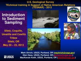
Introduction to Sediment Sampling Siletz, Coquille, Umatilla and Cowlitz Tribes Siletz, OR May 20 – 23, 2013 U.S. Geological Survey TEchnical training in Support of Native American Relations (TESNAR) - 2013 Mark Uhrich, USGS, Portland, OR (mauhrich@usgs.gov) Glen Hess, USGS, Portland, OR (gwhess@usgs.gov) MacKenzie Keith, USGS, Portland, OR (mkeith@usgs.gov)
Fluvial-Sediment Data Needs in the U.S. • Historical: Maintenance of reservoirs, channels, and hydraulic structures/bridge piers • Today’s needs include but are not limited to: - Legal requirements – TMDL’s -Salmon recovery on Tribal Lands (Siletz and Klamath Basins, White Salmon & Elwha River, WA) (Dam decommission and removal) - Contaminated sediment management - Best Management Practice (BMP) Evaluations; Env-Imp-Stat - Fire-burn hydrology/sedimentology - Stream restoration/geomorphic assessments - Physical-biotic interactions - Global carbon budget - Sand budget and bar maintenance - Productivity of agricultural lands -
* • Built in 1909 for hydropower • Head = 7 Meters • Abandoned for power generation in 1960’s • Blocked American shad and striped bass • from reaching historic spawning grounds • Environmental benefits of dam removal • justified demolition by Federal Government
Embry Dam DemolitionFredericksburg, VA, USAFebruary 23, 2004
And in our backyard-the Marmot Dam BreachSandy River, OR, October 19, 2007 955,000 yd3 stored behind reservoir ------------------------------------------------------------------------------------------------------------------------------- 458,000 yd3 released by March 2008 (45%)
And just started- the Elwha River Dam RemovalOlympic National Park, WA September 17, 2011 Largest removal in U.S. history ------------------------------------------------------------------------------------------------------------------------------- 70 miles of river and tributaries will be restored -brings cultural, spiritual and economic healing to the Lower Elwha Klallum Tribe
NF Toutle Station
MSH background and NF Toutle Sed Volumes • Eruption of May 18, 1980 deposited over • 3 billion yd3of sediment in NF Toutle valley • SRS designed to trap 250 million yd3 until 2035, so far trapped over 105 million yd3- yet sediment has filled to level of spillway • Issues: Cowlitz/Columbia R sedimentation, flooding hazards, navigation for shipping commerce, salmon recovery/hatchery • NF Toutle SSLs in million tons and total Q in 1000 cfs (avg Q 786 cfs): • 2007 2008 2009 2010 2011 2012 • SSL 7.0 4.0 1.5 1.2 2.2 2.2 • Q 275 283 234 320 386 355
Sediment Retention Structure - SRS Raising spillway 7 feet, Sept 2012 Spillway
Structures built upstream of SRS USACE - Summer 2010
Sediment Damages are Costly • Physical, Chemical, and Biological Sediment Damages in North America Total >$20-$50 Billion*Annually (Most in the USA; AGU-EOS, 10/5/2004; Science, V.267, pp. 1117-11123; Osterkamp et al. 1998) • Given a 1% Reduction in Damages Through Better Resource Management, a Continental Sediment Monitoring Program WouldPay for Itself at least 40 TimesOver
Scope of course Instruction and field practice of USGS methods for the safe collection of quality-assured fluvial-sediment data: • streamflow measurement • suspended-sediment sampling • bedload sampling
Scope of course (cont) As underpinnings for this we provide instruction on: • Streamflow is everything- must start here • Basic fluvial sediment concepts • Sediment-sampling equipment & deployment • Overview of computational methods • Overview of sediment-surrogate technologies • Bedload Sampling
Primary Assumption • For instructional purposes, our assumed goal is to collect sufficient data to compute sediment loads and store the data in the USGS National Water Information System. • In reality, reasons for collecting sediment data may be quite different – regardless, the following factors remain of primary importance: • Consistency • Reliability • Comparability • Database integrity
Upon Departure, Students Should: • Understand basic streamflow and fluvial-sediment concepts • Understand and appreciate the value of a representative sample and consistent methods • Be familiar with more common tools for collecting sediment data, and their limitations • Be able to safely collect representative • streamflow • suspended-sediment samples isokinetically • bedload samples • Understand basic sediment load calculations
What we will not cover: • Database considerations (such as the USGS National Water Information System; NWIS) • Sediment lab instrumentation and techniques • Network design and developing a sediment monitoring program • Bed-material and pebble-count sampling • Producing a suspended-sediment and bedload record • Best to attend the USGS Sediment Data-Collection Techniques class, in Castle Rock, WA- March 2014 for more detail on the above
Points to remember… • Historical sediment needs- channel & reservoir • Todays needs- more complex; dam removals, restoration, TMDLs, contaminated sediment, etc • Sediment damages are more expensive than establishing a monitoring network • Be consistent with your methods and database • Collect a representative sample for your site • Data should be reliable and comparable site-to-site
One of our class sampling sites is the Siletz River on Hwy 229
D-74 sampler 4-wheel crane setup on bridge with B-reel and two counter weights