Download
1 / 28
280 likes | 441 Vues
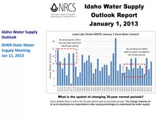
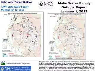
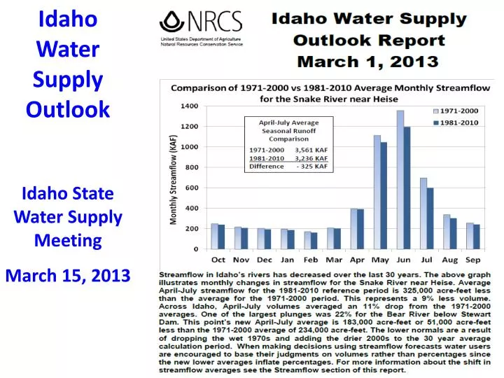
Idaho Water Supply Outlook Idaho State Water Supply Meeting March 15, 2013 . February precipitation was 75% of average. The Clearwater basin snowpack increased slightly from 85% of median on February 1 to 87% on March 1.

E N D
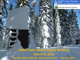
Idaho Water Supply Outlook Idaho State Water Supply Meeting March 15, 2013
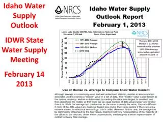
February precipitation was 75% of average. The Clearwater basin snowpack increased slightly from 85% of median on February 1 to 87% on March 1. Precipitation totals are compared to the 1981-2010 AVERAGES whilesnow water equivalent is compared to the 1981-2010 MEDIANS. This may help explain how the snowpack maintained steady percentages during March even with below normal precipitation amounts.
Trend of lack of snow below 6,500 to 7,000 feet is still present in central Idaho and other low elevation basins around state. Result - low runoff in Owyhee, Weiser, Mores, Camas, and eastern Idaho basins: Portneuf, Blackfoot, Grays Lake, Bear
From Sawtooth National Forest Avalanche Advisory March 14, 2013 - Spring is here, and our snowpack has warmed dramatically in the last 48 hours. Yesterday there was a cycle of small wet loose avalanches on steep sunny slopes throughout the advisory area. March 13 - Fully shaded upper elevation slopes are still cold, dry and wintery, marginal slopes that get morning/afternoon sun are melting at the surface (but still dry at depth), solar slopes are wet and losing their winter stratigraphy, and sunny, lower elevation slopes have lost a significant amount of snow.
March 13, 2013 Lewis Lake Divide 24” SWE 32.5” 71-00 Avg 26.8” 81-10 Median 89% of 81-10 Median 74% of 71-00 Avg 76” Depth 32% Density
Year Apr-Sep Runoff 2002 73% twin swe peaks 2012 90% 2013 77% forecast 1968 98% (similar 1963 89% clim years)
Lewis Lake Divide - Snow Water, Precipitation and Soil Moisture very similar to 2012 2013 left side 2012 right side and rest of season
March 12, 2013 Snowpack around Silver City after wind events in early March
Summer image…. Oops, went to deep with the snow tube…. One earth plug in a snow tube…
March 12, 2013 Snowpack around Silver City after wind events in early March
The photos were taken, March 12, in and around Silver City. I also traveled the Reynolds Creek ridge paralleling Jordan Creek and found the dirt or ash everywhere. It is causing the snow pack to drop like a rock, but tributaries not increasing. On the west side of Reynolds Creek, ARS crews are observing widespread dust-on-snow. Our long-term field crew member described what he has seen as “unprecedented”. Dust seems to be especially prevalent in high-accumulation zones like the large drifts, which makes perfect sense (wind-loaded snow = wind-loaded dust). SWE is dropping fast over the last couple of days. …and yes it has been warm and was quite humid a few days ago adding to the heat fluxes – but the drop in SWE over the last several days looks more April-like than March-like.
Owyhee River snowmelt peak flow this weekend ??? Mar 14 peak of ~2600 cfs Spring rain will produce additional peaks like in 2001