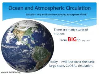
Atmospheric Circulation
Atmospheric Circulation. A Michael Kramer Presentation. The Atmosphere and how it Interacts. The atmosphere is the volume of gases, water vapor, and airborne particles enveloping Earth.

Atmospheric Circulation
E N D
Presentation Transcript
Atmospheric Circulation A Michael Kramer Presentation
The Atmosphere and how it Interacts The atmosphere is the volume of gases, water vapor, and airborne particles enveloping Earth. The gases that enter the atmosphere from the ocean have major effects on climate, sediment deposition, distribution of life, and seawater. Waves that are evaporated from the ocean surface and move by wind (mass movement of air) help decrease extremes of surface temperature, but provide moisture for agriculture.
Atmosphere Continued Weather is the state of the atmosphere at a specific time and place Climate is the long-term average of weather in an area The lower atmosphere contains mostly nitrogen (78.1%) and oxygen (20.9%), with other compounds making up the other 1% Air is never completely dry because water vapor (gaseous form of water) can occupy as much as 4% of its volume. Water leaves the atmosphere by condensing into dew, rain, or snow.
Atmospheric Layers There are five distinct layers of the atmosphere: Troposphere, Stratosphere, Mesosphere, Thermosphere, and Exosphere. These have been identified using thermal characteristics, chemical composition, movement, and density.
Troposphere This is the layer that we live in. It begins at Earth’s surface and extends from 4-12 miles high. The height varies from the equator to the poles As the density of gases in this layer decrease with height, the air becomes thinner. Therefore, temperature also decreases height. Almost all weather occurs in this region. The transition boundary between the Troposphere and the layer above is known as the tropopause. The tropopause and the troposphere are known as the lower atmosphere.
Stratosphere The stratosphere extends from the top of the troposphere to about 30 miles above Earth’s surface. This layer holds about 20% of of atmosphere’s gases, but has little water vapor. Temperature in this region increases with height. Heat is produced with the formation of ozone. The increase of temperature with height means warmer air is higher than cooler air . This prevents convection since there is no vertical movement of gases, which allows for “anvils” at the tops of cumulonimbus clouds. The transition which separates the stratosphere and the mesosphere is called the stratopause.
Mesosphere The mesosphere extends from the top of the stratosphere to about 56 miles above Earth’s surface. The gases, including the oxygen molecules, continue to grow thinner and thinner with height. The effect of warming by ultraviolet radiation becomes less and less and that leads to a decrease in temperature with height. But, the gases in the mesosphere are very strong that it slows down meteors hurtling into the mesosphere, which in turn leave fiery trails in the night sky. The stratosphere and the mesosphere make up the middle atmosphere. The transition boundary which separates the mesosphere from the thermosphere is called the mesopause.
Thermosphere The thermosphere extends to about 375 miles above Earth’s surface. This layer is known as the upper mesosphere. The gases in the thermosphere are a lot thinner than in the mesosphere. As a result, high energy ultraviolet and x-ray radiation causes a high temperature increase. Because molecules absorb incoming energy, temperature increases with height, but the atmosphere would still feel very cold to our skins because of the thin air.
Exosphere The exosphere is the outermost layer. It extends to 6,200 miles above the Earth. In this layer, Atoms and molecules escape into space and satellites orbit space.
Ionosphere The Ionosphere is located within the thermosphere and is made up of electronically charged gas particles (charged = ionized). It extends from 37 to 190 miles above the Earth’s surface. There are three regions of the Ionosphere: F layer, E layer, and D layer. The F layer splits into two during the day and the recombines at night. The E layer was the first to be found when Marconi transmitted signal between Europe and North America and showed that it had to bounce off an electrically conducting layer about 62 miles above the surface. Appleton called this layer the (E)lectrical-Layer. The D layer undergoes the greatest density change and essentially disappears at night. The density of the ionosphere from daytime to nighttime because of the radiation from the sun striking the atmosphere. They are all more dense in the morning. The important quality of the ionosphere is that it bounces radio signals transmitted from Earth. Because of the ionosphere, the whole world can be reached through radio.
Key Terms to Know The heat-input and heat-outflow “account” for Earth is its heat budget. The Earth is in thermal equilibrium, as it is growing neither significantly warmer nor colder The circulation current of air in the room, a convection current, is caused by the difference in air density resulting from the temperature difference between the ends of the room. A Monsoon is a pattern of wind circulation that changes with the season
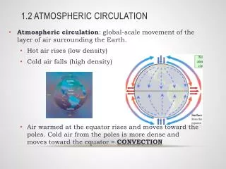
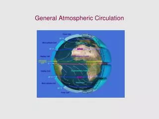
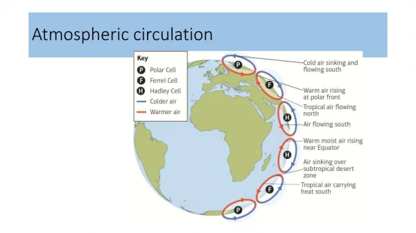
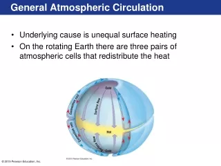
Atmospheric Circulation Cells An atmospheric circulation cell is a large circuit of air driven by solar heating and the Coriolis effect. There are three in each hemisphere, for a total of six: Ferrel cell, Hadley cell, and Polar cell. A Ferrel cell are the mid-latitude cells of each hemisphere. They rise at 60 degrees latitude and fall at 30 degrees latitude. A Hadley cell exists in the tropics, one on each side of the equator. These cells are nearest to the equator and fall because of cooling at 30 degrees latitude. A Polar cell is the cell centered over each pole. The boundary between the polar cell and the Ferrel cell is known as a polar front.
Circulation Wind Patterns Doldrums are the zone of rising air near the equator known for sultry air and variable breezes, also referred to as equatorial lows. Scientists refer to this region as the Intertropical Convergence Zone (ITCZ). The ITCZ doesn’t coincide with the geographical equator, but instead lies at the meteorological equator Horse latitudes are the zones of erratic horizontal surface air circulation near 30 degrees north and 30 degrees south latitudes. Over land, dry air falling from high altitudes produces deserts at these latitudes (i.e. the Sahara) Trade Winds are the surface winds within the Hadley cells, centered at about 15 degrees latitude that approach from the northeast in the Northern Hemisphere and from the southeast in the Southern Hemisphere. Westerlies are surface winds within the Ferrel cells, centered around 45 degrees latitude. They approach from the southwest in the Northern Hemisphere and northwest in the Southern.
Breezes A sea breeze is when cooler air from over the sea moves toward land. A land breeze is when the breeze direction will reverse. Land and Sea breezes are small, mini-monsoons. This heats and warms the land and the sea. The land’s temperature rises at a faster rate than the sea. These breezes are common in coastal areas.
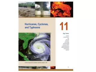
Storms and Cyclones Storms are regional atmospheric disturbances characterized by strong winds often accompanied by precipitation. There are two types of great storms: tropical cyclones and extratropical cyclones. Both of these are cyclones, huge rotating masses of low-pressure air in which winds converge and ascend. Cyclone storms form between or within air masses, large bodies of air with nearly uniform temperature, humidity, and density throughout. Air masses can move within or between circulation cells. Density differences will prevent air masses from mixing, where energy is needed to mix air masses. The boundary between air masses of different density is called a front. A tropical cyclone are great masses of warm, humid, rotating air. They occur in all tropical oceans except the equatorial South Atlantic. An Extratropical cyclone forms at the boundary between each hemisphere’s polar cell and its Ferrel cell, known as the polar front. A cyclone is NOT a tornado, a smaller funnel of fast-spinning wind associated with severe thunderstorms.
Cyclone Relationships to other types of Storms Large tropical cyclones are also called hurricanes in the North Atlantic and eastern Pacific, typhoons the western Pacific, tropical cyclones in the Indian ocean, and willi-willis in the waters near Australia. For a cyclone to qualify as a hurricane or typhoon, the tropical cyclone must have winds of at least 119 km (74 miles) per hour. About 100 tropical cyclones grow to hurricane status each year, while a very few of these develop into superstorms that have winds that can exceed 250 km per hour. Tropical cyclones containing winds less than hurricane force are called tropical storms and tropical depressions.
Cyclones Continued The calm center, or eye, of a storm (about 8-10 miles in diameter) is sometimes surrounded by clouds so high and dense that the daytime sky looks dark. Unlike extratropical cyclones, a mature tropical cyclone is generated within one warm, humid air mass that forms between 10 degrees and 25 degrees latitude in either hemisphere. While tropical cyclones turn counterclockwise in the Northern Hemisphere and clockwise in the Southern Hemisphere, the Coriolis effect might still apply to cyclones because approaching air is deflected right in the Northern Hemisphere and opposite in the Southern Hemisphere. A tropical cyclone usually develops from a small tropical depression, which form in easterly waves (areas of lower pressure within the easterly trade winds that are thought to originate over a large, warm landmass). Condensation begins when humid air is forced upward, and then the storm takes shape.
Hurricanes A hurricane is an intense tropical cyclone with sustained winds exceeding 119 km per hour. Hurricanes consist of a tightly organized band of thunderstorms surrounding a central eye. There are five different categories for hurricanes. Category 1: 74-95 miles per hour wind speed; 4-5 feet storm surge; damage to trees, shrubs, and unanchored mobile homes Category 2: 96-110 miles per hour wind speed; 6-8 feet storm surge; some trees blown down, major damage to exposed mobile homes, roof damage to permanent structures Category 3: 111-130 miles per hour wind speed; 9-12 feet storm surge; Foliage removed from large trees, mobile homes destroyed, structural damage to permanent buildings Category 4: 131-155 miles per hour wind speed; 13-18 feet storm surge; All signs blown down, complete roof structure on small residences, extensive damage to windows, major erosion of beach areas, terrain may be flooded well inland Category 5: Greater than 156 miles per hour win speed, greater than 19 feet storm surge; complete roof failure on many residences and industrial buildings, small buildings blown away, evacuation of residential areas required, major flooding
Atlantic Hurricane Season of 2005 Most destructive hurricane ever recorded A record of 27 tropical cyclones formed, with 15 of these becoming hurricanes. Three hurricanes were Category 5 (Hurricane Katrina, Rita, and Wilma) Storm surge caused the greatest loss of life and property when Katrina struck the gulf coast. (Storm surge in Bay St. Louis was 34 feet high) In Louisiana alone, more than 100 square miles of wetlands were torn apart and their ability to support a rich variety of species was essentially destroyed
Key Concepts Atmosphere and Ocean interact with each other Atmosphere consists of mainly nitrogen, oxygen, and water vapor The Atmosphere moves in response to uneven solar heating and Earth’s rotation Atmospheric Circulation generates Large-Scale Surface wind patterns Storms are variations in large-scale atmospheric circulation
Bowl Quiz Time! Multiple Choice The Horse Latitudes are located at which of the following latitudes W: Equator X: 30 degrees Y: 60 degrees Z: Poles
Multiple Choice The Horse Latitudes are located at which of the following latitudes W: Equator X: 30 degrees Y: 60 degrees Z: Poles
Short Answer The ITCZ does not coincide with the geographical equator, but instead lies at what? Answer: meteorological equator
Multiple Choice Which of the following is NOT associated with a tropical cyclone? W: Hurricane X: Typhoon Y: Tornado Z: Willi-willi
Multiple Choice Which of the following is NOT associated with a tropical cyclone? W: Hurricane X: Typhoon Y: Tornado Z: Willi-willi
Short Answer For a Cyclone to be classified as a hurricane, the tropical cyclone would need to exceed a wind speed of what? Answer: 119 km/h OR 74 mph
Multiple Choice Which of the following categories of hurricanes best matches the damages consisting of foliage removed large trees and mobile homes destroyed, with a storm surge between 9 and 12 feet? W: Category 2 X: Category 3 Y: Category 4 Z: Category 5
Multiple Choice Which of the following categories of hurricanes best matches the damages consisting of foliage removed large trees and mobile homes destroyed, with a storm surge between 9 and 12 feet? W: Category 2 X: Category 3 Y: Category 4 Z: Category 5