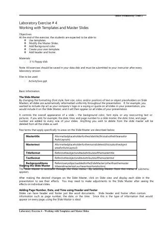
Working with Development Templates
This guide explores the evolution and optimization of development templates created by CUSPA, focusing on cluster analysis and new template introductions. Documenting the challenges faced, such as matching density ranges and ensuring comprehensive representation of land uses, it emphasizes the importance of the "Templates Used" spreadsheet for diagnosing issues. Insights into adjusting percent land overhead values and right-sizing land for development are provided, ensuring efficient use of available parcels in alignment with density and land use constraints.


Working with Development Templates
E N D
Presentation Transcript
?! Working with Development Templates
Template Origins • Original Template table developed by CUSPA • Cluster analysis • PSRC added: • New Templates • Percent Land Overhead values • Development Constraints • What helped • “Templates Used” spreadsheet- see what was(n’t) used after a run
Diagnosing Problems 1. Mapping the location of templates built 2. Examining which templates were chosen, esp. by building type. Good way to figure out if a type of building or density level is not being constructed
Issues We Ran Into • Template density ranges • Need to create templates with densities that match constraints • Although, still not building to max capacity in some places • Constraint land uses • Make sure the all of the land uses that could possibly be built with that plan type id are represented
Right Sizing & Fudging • Percent Land Overhead • In templates table • Change to reflect unused land on a parcel (setbacks, RoW, drainage) • Vary by land use and density (if necessary) • Sq Ft per Unit • In the template components table • Is it accurate for the template’s development
Relating Parcels, Templates, & Constraints Parcels The constraints permit which land uses and densities are allowed on a parcel. The tables are linked by plan type id. DevelopmentConstraints Templates are selected when the template’s density and land use type fit within the constraints of a parcel with enough land. Development Templates
Land for Development • Parcel SFt – Land Area Taken = Land available for development • Templates fit where enough available land (- % Land Overhead)
Early example of Min-Max parcel size fit issue Only 2 templates allowed for a parcel in Enumclaw UGA: Parcel ID = 587870 2.9 Min Units, 5.2 Max Units 19.9 acres
Checking min and max Sqft of templates versus density – do we have coverage?