Download
1 / 40
400 likes | 538 Vues
Daily Operation and Validation of a Global Assimilative Ionosphere Model. USC/JPL GAIM. Brian Wilson, JPL George Hajj, JPL, USC Lukas Mandrake, JPL Xiaoqing Pi, JPL, USC Chunming Wang, USC Gary Rosen, USC. Beacon Satellite Symposium, Trieste, Italy, Oct. 18-22, 2004. Outline.

E N D
Daily Operation and Validation of a Global Assimilative Ionosphere Model USC/JPL GAIM Brian Wilson, JPL George Hajj, JPL, USC Lukas Mandrake, JPL Xiaoqing Pi, JPL, USC Chunming Wang, USC Gary Rosen, USC Beacon Satellite Symposium, Trieste, Italy, Oct. 18-22, 2004
Outline • USC/JPL GAIM uses two assimilation techniques: • Sparse Kalman filter • 4DVAR with an Adjoint model to estimate drivers • Extensive Validation • Case Studies and Continuous, Daily Validation • Daily GAIM Kalman Runs • Specify Yesterday’s Ionosphere • Daily since March 2003 • RT GAIM: Operational Prototype • Since April 2004 • Input GPS data every 5 minutes and estimate new density grid • Validate every hour against GPS, every 3-4 hours against JASON Beacon Satellite Symposium, Oct. 18-22, 2004
USC/JPL Global Assimilative Ionosphere Model (GAIM) • Physics-Based Forward Model, Matching Adjoint Model • Developed to explicitly support data assimilation • Use Kalman filter and 4DVAR (with adjoint model) to simultaneously solve for: • 3D ion & electron density state every 5 minutes • Key ionospheric drivers such as low-latitude ExB vertical drift, neutral winds, & production terms • Opportunity to take advantage of new global data sources: • Ground GPS network (>900 daily sites, >170 hourly sites) • FUV radiances (LORAAS, GUVI, DMSP SSUSI/SSULI) • COSMIC GPS occultation constellation (6 sats.) • Continuous daily GAIM runs & validation against: • TOPEX vertical TEC, independent GPS slant TEC • Ionosonde FoF2, HmF2, & bottom-side profiles • Density profiles from Abel Inversions of occultation data Beacon Satellite Symposium, Oct. 18-22, 2004
State and covariance Analysis State and covariance Forecast Adjustment Of Parameters Kalman Filter 4DVAR General Structure of GAIM Driving Forces Physics Model Mapping State To Measurements Innovation Vector Beacon Satellite Symposium, Oct. 18-22, 2004
Forward Model • Eulerian Grid Elements in p-q Magnetic Coordinates • Variable Element Size • Solve for Ion densities using Finite Volume Method • Efficient Forward Propagation of the State • Unconditionally Stable Time Integration • Explicitly Compute Partial Derivatives needed for Kalman & 4DVAR optimization. Beacon Satellite Symposium, Oct. 18-22, 2004
Optimization Approach: 4DVAR • Non-linear least squares minimization • Cost function to compute model deviation from observations • Adjoint method to compute gradient of cost function: computational efficiency • Minimization: finding roots using Newton’s method by estimating driving parameters • Parameterizationof model drivers Estimate ionospheric drivers and optimize the state Beacon Satellite Symposium, Oct. 18-22, 2004
Estimation of Ionospheric Dynamical Drivers • Observation System Simulation Experiments (OSSE) to estimate “perturbed” drivers at low latitudes: • Neutral winds • EB vertical drift velocity • Production terms • Synthetic ground GPS TEC data Beacon Satellite Symposium, Oct. 18-22, 2004
Need Sensitivities to Adjust Drivers • Use Physics Model as a Black Box • Run Forward Model twice for different parameter choices • Difference resulting densities to compute numerical derivatives (grid of sensitivities) • Repeat for each driver parameter • Implies large number of forward model runs • Develop Adjoint Model corresponding to the Forward Model • Run Forward Model once • Run Adjoint Model once • During Adjoint run all parameter sensitivities are computed • Use sensitivities in 4DVAR optimization or extended Kalman filter to adjust drivers Beacon Satellite Symposium, Oct. 18-22, 2004
Parameter Grid and GPS Stations • Number of stations: 12/07/2002: 31 • Observation links: ~2240/ hour, sampled at 5-minute epochs Beacon Satellite Symposium, Oct. 18-22, 2004
Estimation of Ionospheric Dynamical Drivers • Observation System Simulation Experiments (OSSE) to estimate “perturbed” drivers at low latitudes: • Neutral winds • EB vertical drift velocity • Production terms • Synthetic ground GPS TEC data Beacon Satellite Symposium, Oct. 18-22, 2004
Improved Drivers => Improved Forecasting • Improved drivers enable more accurate “nowcast” and forecast of 3D electron density. • Plot differences between simulated ionospheric “weather” and assimilation results for vertical TEC and Ne profiles. Beacon Satellite Symposium, Oct. 18-22, 2004
State Model Measurement Model Noise Model Kalman Filter Equations Beacon Satellite Symposium, Oct. 18-22, 2004
Correlation Scale Band-Limited Kalman Using Physical Correlation Lengths sij = Corr. between voxel i and j si = Uncertainty in density in voxel i R = Correlation length in altitude Q = Correlation length in latitude F = Correlation length in longitude Beacon Satellite Symposium, Oct. 18-22, 2004
Approximate Kalman: Save only part of covariance matrix based on physical correlation lengths. Tested extensively with real data: Ground GPS TEC from 100-200 global sites. Validate densities against: Vertical TEC obs. From TOPEX Ionosonde FoF2, HmF2, & bottomside profiles Slant TEC obs. from independent ground GPS sites. Density profiles retrieved from space-based GPS occultations Band-Limited Kalman Filter Beacon Satellite Symposium, Oct. 18-22, 2004
Summary Of No. Of Operations ApproachNo. of Operations Full Kalman 28800 N2 + M N2 Optimal Interpolation 2 N M Band Limited A N M M = No. of measurements N = No. of Voxels A = No. of neighbor elements with non-zero covariance Beacon Satellite Symposium, Oct. 18-22, 2004
Data Types Available • Ground GPS Data (Absolute TEC) • >150 5-min. to Hourly Global GPS Ground Stations • Assimilate >300,000 TEC points per day (@ 5 min rate) per day • Space GPS Data (Relative TEC) • CHAMP (@ 440 km) • SAC-C (@ 700 km) • IOX (@ 800 km) • GRACE (@ 350 km) • Topex/Poseidon (@1330 km) (Upward looking only) • Jason 1 (@1330 km) (Upward looking only) • C/NOFS & COSMIC constellation • UV airglow data (135.6 nm) • LORAAS on ARGOS, GUVI on TIMED • SSUSI/SSULI on DMSP • Other Data Types • TEC from TOPEX Altimeter • Ionosonde • DMSP in situ • CHAMP in situ • GRACE Cross links • ISR Beacon Satellite Symposium, Oct. 18-22, 2004
200 Daily GPS Sites (04/2004) Beacon Satellite Symposium, Oct. 18-22, 2004
Validation Datatypes (or Alt. Retrievals) • TOPEX vertical TEC • Absolute slant TEC from independent ground GPS sites • Relative TEC links from flight GPS receivers • Density profiles from Abel retrievals (from occultations) • Ionosonde critical parameters or bottomside density profiles • NRL 2D density retrievals from UV limb scans • ==== • Density profiles from SSUSI/SSULI pre-processing • In-situ densities from DMSP & C/NOFS • C/NOFS Electric fields (low latitude drivers) • CHAMP in-situ densities (450 km altitude) • GRACE in-situ densities (500 km, from crosslinks) • Density profiles from ISR’s (Madrigal database) • Etc. Beacon Satellite Symposium, Oct. 18-22, 2004
Validation Case Studies using GAIM Kalman Beacon Satellite Symposium, Oct. 18-22, 2004
TOPEX vs. GAIM using ground GPS Beacon Satellite Symposium, Oct. 18-22, 2004
TOPEX vs. GAIM using ground GPSand IOX Occultations Track #10 on 2002/07/23 Beacon Satellite Symposium, Oct. 18-22, 2004
GAIM vs. Abel Comparisons at the Occultation Tangent Point • Profiles are obtained by: • Abel Inversion (“abel”) • GAIM Climate (no data) (“clim”) • GAIM Analysis assimilating ground TEC data only (“ground”) • GAIM Analysis assimilating IOX TEC data only (“iox”) • GAIM Analysis assimilating both ground and IOX data (“ground+iox”) Beacon Satellite Symposium, Oct. 18-22, 2004
EXAMPLES OF PROFILES RETRIEVED BY USE OF DIFFERENT DATA SETS Beacon Satellite Symposium, Oct. 18-22, 2004
GAIM vs. Abel NmF2 Comparison Beacon Satellite Symposium, Oct. 18-22, 2004
GAIM vs. Abel HmF2 Comparison Beacon Satellite Symposium, Oct. 18-22, 2004
Daily GAIM Operations (Mar 2003 - Present) • Using Physics-Based, Band-Limited Kalman Filter • Driver adjustment will be added soon • Actually two runs each day: • Test bed to compare different covariance strategies and grid resolutions • Input 100-200 globally-distributed GPS TEC sites • Continuous validation against: • Vertical TEC from TOPEX • Slant TEC from independent GPS sites • FoF2 & HmF2 from ionosondes (but QC issue) Beacon Satellite Symposium, Oct. 18-22, 2004
TOPEX Comparisons for Mar 11 - Dec 31, 2003:GAIM versus GIM & IRI95 Beacon Satellite Symposium, Oct. 18-22, 2004
TOPEX Comparisons for Mar 11 - Dec 31, 2003:GAIM Assim. at Low vs. Mid & High Latitudes Beacon Satellite Symposium, Oct. 18-22, 2004
Plasma Redistribution October 30, 2003 CHAMP Vertical TEC October 30, 2003 (430 km altitude) Beacon Satellite Symposium, Oct. 18-22, 2004
Global RT GAIM Prototype • Input data is ground GPS TEC: • Every 5 minutes from 58 1-sec. streaming sites (~450 pts) • Every hour from ~150 sites • Sparse Kalman Filter • Update global 3D density grid every 5 minutes • 30,000 elements in variable grid • Res: 2-3º in latitude, 7º in longitude, 30-50 km in altitude • Runs on a dual-CPU Linux workstation • Validation: • Every hour against independent GPS TEC values • Every 3-4 hours against vertical TEC from JASON • Every day (post-analysis) against ionosonde and other data Beacon Satellite Symposium, Oct. 18-22, 2004
58 Streaming GPS Sites (04/2004) Beacon Satellite Symposium, Oct. 18-22, 2004
150 Hourly GPS Sites (04/2004) Beacon Satellite Symposium, Oct. 18-22, 2004
Global RT GAIM Prototype • Input data is ground GPS TEC: • Every 5 minutes from 58 1-sec. streaming sites (~450 pts) • Every hour from ~150 sites • Sparse Kalman Filter • Update global 3D density grid every 5 minutes • 30,000 elements in variable grid • Res: 2-3º in latitude, 7º in longitude, 30-50 km in altitude • Runs on a dual-CPU Linux workstation • Validation: • Every hour against independent GPS TEC values • Every 3-4 hours against vertical TEC from JASON • Every day (post-analysis) against ionosonde and other data Beacon Satellite Symposium, Oct. 18-22, 2004
Ionization Response to Flare, Oct. 28, 2003 Beacon Satellite Symposium, Oct. 18-22, 2004
Global TEC Map Generated Every 5 Minutes Beacon Satellite Symposium, Oct. 18-22, 2004
Add Frame to Density Movie Every 15 Minutes Beacon Satellite Symposium, Oct. 18-22, 2004
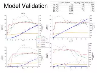
JASON TEC Comparison - Daytime Track Beacon Satellite Symposium, Oct. 18-22, 2004
JASON TEC Comparison - Nighttime Track Beacon Satellite Symposium, Oct. 18-22, 2004
Programmatic Issues in the Era of Space Weather Data Assimilation • A robust ionospheric data assimilation program must include continuous cross-comparisons of multiple models. • As in weather, NCEP vs. ECMWF, etc. • All sensors should be or plan to be real-time. • All datasets should be publicly available, at least after a time delay. • Data quality and model accuracies must be continuously validated. • Need RT validation and long-term reanalysis. Beacon Satellite Symposium, Oct. 18-22, 2004
Summary of USC/JPL GAIM Status • USC/JPL GAIM band-limited Kalman filter has been extensively tested with *real* data. • Case studies (single datatype & combined): • TEC from ground GPS • DTEC from GPS occultations (IOX, CHAMP, SAC-C) • UV radiances from nighttime scans (LORAAS, GUVI) • Daily and RT Kalman runs using ground GPS data • Global and regional high-resolution runs • Add COSMIC occultations & DMSP UV radiances • Add other datatypes as available: ionosonde, C/NOFS • Challenge of understanding multiple input datatypes! • Intent: Run Daily and RT forever using all available data. • Add adjusted drivers from 4DVAR soon Beacon Satellite Symposium, Oct. 18-22, 2004