Download
1 / 63
640 likes | 910 Vues
The Relationships Between Plate Boundaries and Tectonic Landforms. The earth’s surface is covered with a variety of wonderful and interesting landforms…. Island arcs. Volcanoes. Mountains. And valleys bordered by steep cliffs,. Just to name a few!. How did these landforms originate?.

E N D
The Relationships Between Plate Boundaries and Tectonic Landforms
The earth’s surface is covered with a variety of wonderful and interesting landforms… Island arcs Volcanoes Mountains
And valleys bordered by steep cliffs, Just to name a few!
How did these landforms originate? How does it relate to our dynamic, changing earth? …These are questions that curious and analytical scientific minds have only really been able to answer in the last 40-50 years!
Courtesy of pictures from NASA’s website: “Earth from Space” http://earth.jsc.nasa.gov/land.html We are going to take a “Virtual Tour” of the Earth to explore these Tectonic Landscapes and put into “real-world” context what we have learned in class.
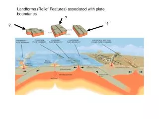
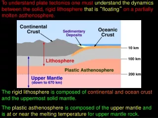
But first a review… An important modern theory about the forces that drive plate tectonics is that the plastic, partially melted asthenosphere is undergoing convection. This movement of materials below the earth’s lithosphere is thought to be causing the plates of the earth’s lithosphere to move too!
As you have learned, where there is upwelling of the asthenosphere, the crust above spreads apart, and new material from below bulges up into ridges. Where there is subsidence of the asthenosphere, the crust is being pulled down along with it to form depressions, or trenches. This can be visualized superbly in this diagram.
This movement of the astheno-sphere causes the lithosphere plates to be pulled apart or pushed together! This creates the different plate boundaries, which in turn creates the landscapes we see on earth today!
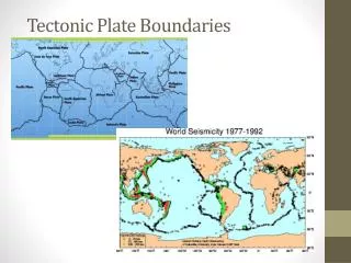
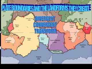
Let’s review the 3 types of plate boundaries we have discussed so we can better understand the pictures we are about to see.
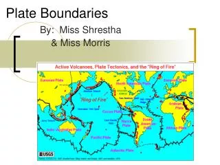
Plate Boundaries 1.Divergent: Where tension forces are pulling the earth’s plates apart. (where plates move away from each other) • Convergent: Where compression forces push the earth’s plates together • (where plates crash into each other) • Transform: Where shearing forces cause the earth’s plates to slide past each other. • (where plates rub against each other in opposite directions)
How do scientists know where plate boundaries are, and of what type? By studying where the earth is under stress. How do scientists know where the earth is under stress? By identifying where earthquakes are and how deep they are!
Shallow earthquakes are found along divergent, transform, and rift boundaries, and where continental crust is colliding. Deep earthquakes are found along what kind of zones?! * * *
O.K.! Enough Review! Let’s take off and look at some real-life landforms! Our first stops will take us to CONVERGENT boundaries. Stop 1: Oceanic crust colliding into oceanic crust
COUNTDOWN…. 5 4 3 2 1
We are going to fly over Alaska and the Aleutian Islands What features should we be looking for? Aleutian Islands
Turn to page 5 in your Earth Science Reference Tables… What tectonic feature do you see associated with the Aleutian Islands?
Volcanic Island Arcs are associated with trenches! Why is this so?!
What type of lava would be extruding from these volcanoes? (See page 6 of your reference tables.)
We will be visiting the state of Washington in order to view plate tectonic features that resulted when the Juan de Fuca Plate (oceanic crust) collided with the North American Plate (continental crust.) Based on the map to the right, and in the next slide, what features should we be looking for?
A similar situation exists in western South America, but the plates involved are different. What plates are involved in this collision between oceanic and continental crust?
Now we’re off to Chile and Peru to check out the landforms there! Stop 3: South America
Look at your reference table again. What feature do you see on the west side of South America that is associated with convergent boundaries and the subduction that results? What is probably happening to the asthenosphere here?
Again, what type of lava would be extruding from these volcanoes in Washington State and western South America?
Stop 4: Continental crust colliding with continental crust What features do we expect to find here?
We’re off to Southeastern Asia, one of the best places to observe this type of plate boundary! China India Nepal
Himalayas India China
Mount Everest 29,035 feet tall! (8850 meters)
Use your reference table to determine what plates are colliding to form the Himalayas.
Now we have reached the second part of our journey: Stops 5&6: Exploring DIVERGENT boundaries…
A flight over part of Africa’s Rift Valley will demonstrate this.
First, find the East African Rift on your reference table and determine what plate the rift is found on.
Here are some volcanoes from the Rift Valley. Knowing this is a divergent zone, what type of lava will extrude from them? Steep cliff of rift valley Lengai Volcano
And here are some dramatic pictures of the lava from these volcanoes!
…And now to explain how rifting can form volcanoes AND large lakes…
The uprising asthenosphere here has caused tension forces which have pulled apart the continental crust. ..and magma coming from the spreading center can form volcanoes! The brittle crust has fractured and a section in the middle has downfaulted into the developing gap (rift.) Water filled into the gap, creating a freshwater lake. There are two stunning examples of this in Africa!