
Uploaded by
lynne
1 SLIDES
249 VUES
10LIKES
ARIZONA
DESCRIPTION
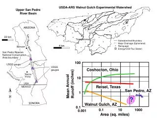
San Pedro Riparian. National Conservation. Area boundary. USDA-ARS Walnut Gulch Experimental Watershed. Upper San Pedro River Basin. ARIZONA. 20 km. Tombstone. Subwatershed Boundary. Major Drainage (Ephemeral). 4 km. Rainguage. Benson. Energy/CO2 Flux Station. 100. USGS gauge.
Download
1 / 1
Download Presentation

Télécharger la présentation
ARIZONA
An Image/Link below is provided (as is) to download presentation
Download Policy: Content on the Website is provided to you AS IS for your information and personal use and may not be sold / licensed / shared on other websites without getting consent from its author.
Content is provided to you AS IS for your information and personal use only.
Download presentation by click this link.
While downloading, if for some reason you are not able to download a presentation, the publisher may have deleted the file from their server.
During download, if you can't get a presentation, the file might be deleted by the publisher.
E N D
Presentation Transcript
San Pedro Riparian National Conservation Area boundary USDA-ARS Walnut Gulch Experimental Watershed Upper San Pedro River Basin ARIZONA 20 km Tombstone Subwatershed Boundary Major Drainage (Ephemeral) 4 km Rainguage Benson Energy/CO2 Flux Station 100 USGS gauge USGS gauges Coshocton, Ohio Sierra Vista 10 Mean Annual Runoff (inches) USA Reisel, Texas MEXICO San Pedro, AZ 1 ? SONORA Walnut Gulch, AZ 0.1 0.1 10 1000 0.001 Area (sq. miles)


More Related
Audio
Live Player