1 / 11

River Landforms represented on O.S. Maps

River Landforms represented on O.S. Maps. V-Shaped Valley. Interlocking Spurs. Waterfall. Meander Examples. Lacustrine Delta. Exam Questions. Glacial Landforms represented on O.S. Maps. Truncated spurs

maeve
Télécharger la présentation

River Landforms represented on O.S. Maps

An Image/Link below is provided (as is) to download presentation Download Policy: Content on the Website is provided to you AS IS for your information and personal use and may not be sold / licensed / shared on other websites without getting consent from its author. Content is provided to you AS IS for your information and personal use only. Download presentation by click this link. While downloading, if for some reason you are not able to download a presentation, the publisher may have deleted the file from their server. During download, if you can't get a presentation, the file might be deleted by the publisher.

E N D

Presentation Transcript


  1. River Landforms represented on O.S. Maps

  2. V-Shaped Valley

  3. Interlocking Spurs

  4. Waterfall

  5. Meander Examples

  6. Lacustrine Delta

  7. Exam Questions

  8. Glacial Landforms represented on O.S. Maps

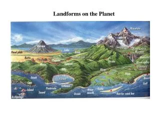
  9. Truncated spurs • Before glaciation, relatively immature rivers display a pattern of interlocking spurs. A valley glacier cannot avoid the interlocking spurs as a river can. As the valley glacier moves, abrasion and plucking erode the protruding tips of the spurs, leaving steep cliff-like truncated spurs.  • Hanging valleys are found in between truncated spurs as they join the main glacial valley from the side. It is common for waterfalls to form from them, where they fall into the main valley. Such truncated spurs can be found in mountainous regions.

More Related