Landforms on the Planet
Earth's geography is a mosaic of diverse landforms, each with unique characteristics and ecosystems. Oceans cover 71% of the planet, hosting unparalleled biodiversity. Seas are large bodies of water partially enclosed by land, while prairies are vast, treeless grasslands. Elevated plateaus offer expansive views, and mountains rise steeply, like Everest. Volcanic islands and atolls shape coastlines, while peninsulas and deltas define land-water interactions. Understanding these forms - from bays to straits - reveals our planet's intricate environmental tapestry.
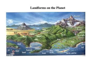

Landforms on the Planet
E N D
Presentation Transcript
Ocean* -- a great expanse of salt water. • The oceans occupy 71% of the surface of the planet and there is a great diversity of animal life that can be found in the oceans and nowhere else.
sea* -- a relatively large body of water, either part of an ocean that is partially surrounded by land (the Caribbean Sea), or a body of water that is completely landlocked
prairie -- an extensive area of flat or rolling, mostly treeless grassland. This image is of the prairie of Saskatchewan. If you want to see a really, really flat terrain, then drive up to the prairie province of Canada and you can see forever. If you do not want to go so far, just head west from Grand Forks, North Dakota. It isn't much different. One thing that describes this terrain is the winds. Even small amounts of snowfall become huge drifts due to the wind and no geolographic feature to block them.
plateau -- an elevated level expanse of land; a tableland. I suppose that you could use the image above to see a plateau, but I have added the Tibetan Plateau, as seen below, because it is a great elevation, and quite expansive
mountain -- An high, steep elevation of the earth's surface, higher than a hill. Okay, mountains are obvious features. Below is the space view of Everest, and to its right is the climbers view before the ascent into the "death zone" where oxygen is scarce and climbing dangerous.
volcano -- An opening in the earth's crust through which molten lava, ash, and gases are ejected. it is the Hawaiian volcano at Kiluaea that I have included in this page.
archipelago* -- a chain of islands. I would be remiss as a biologist if some reference to the famous Galapogas Islands was not referenced or directly included in this course. Here is a nice space satellite image of this collection of islands to the west of South America.
island -- a piece of land completely surrounded by water. Okay, so the picture above shows island. Why do we need to see another one below? Well, because it is a landform, so take a nice look at Mauna Loa which is a mountain, a volcano, and most of the Island of Hawaii ... all in one image from space.
atoll - a ring (or partial ring) of coral that forms an island in an ocean or sea. Typically, the volcanic mountain that rose up out of the sea was covered by coral just off the shore of the island. As wind, rain, and other forms of weather eroded the volcanic mountain, the coral would still grow at the boundary between land and ocean. When erosion completely wiped out the island, all that remains is the ring of coral around what used to be an island. The atoll that is most familiar to me ... Kure Atoll is the northernmost Hawaiian "island." On July 25, 1946, the US detonated a nuclear bomb in the middle of Bikini Atoll. Below and right is a look at that event.
peninsula* -- a narrow stretch of land surrounded on three sides by water. I have chosen to the Baja, which sticks out south of California
gulf* -- A large area of a sea or ocean partially enclosed by land (the Gulf of Mexico). This picture of the Gulf of Mexico was taken as Hurricane Katrina was rolling in during the the spring of 2005.
bay -- an area of sea partially enclosed by land, smaller than a gulf. Well, the Hudson Bay isn't very small, but it is well known, and in the image below, it is seen when covered by ice.
sound* -- a long passage of water connecting two larger bodies. The best known sound in the US is the Puget Sound of northwest Washington
isthmus* -- a narrow strip of land, like a bridge, connecting two larger strips of land. What better image than that of the country of Panama.
delta -- a place at the river's mouth, where the river splits into many different sections, forming a marshy triangle. This delta is found in Greenland and obviously does not form a marshy triangle. Marshland is not definitive of a delta, but the triangle of waterways is.
river mouth -- the place where a river empties into a larger body of water. The Mississippi River mouth is seen in the image below. Note all of the sediment that has been deposited into the Gulf of Mexico by this river. river source - if the river mouth is a landform, then so too could the river source be. A source is the beginning of a river, and while it is nowhere as geologically interesting as the mouth is, some of these places are pretty. My favorite river source is the headwaters of the Rapid River in the Black Hills. I have been camping there as a student, teacher, and tourist with my family.
harbor -- a sheltered part of a body of water deep enough to provide anchorage for ships. The famous Pearl Harbor of Oahu, Hawaii is seen to the lower left of center in the photograph.
strait -- A narrow channel of water joining two larger bodies of water (usually narrower than a sound). My favorite strait is the Bosporous Strait in Turkey. The city of Istanbul occupies both sides of this straight strait of water.
cape -- A point or head of land projecting into a body of water. And what cape is better known that Cape Cod, Mass.
river -- A large natural stream of water emptying into an ocean, lake, or other body of water. I have included this great space photograph of the Amazon River with its many tributaries ... a landform mentioned below this image too. tributary* -- A stream that flows into a larger stream or other body of water
valley -- An elongated lowland between ranges of mountains, hills, or other uplands, often having a river or stream running along the bottom. This picture was circulating around the internet e-mail a few months ago, and I thought it was too spectacular to leave out.
fjord - a long, narrow sea inlet that is bordered by steep cliffs. Many Minnesotans have their heritage in Norway, and this country undoubtedly has some of the beautiful fjords in the world
divide* -- a ridge of land that marks the directional flow of rivers on either side. I have visited the Continental Divide in Colorado, Montana, and even in the Yukon. This image is of the divide in the Colorado Rockies.
moraine* -- An accumulation of boulders, stones, or other debris carried and deposited by a glacier. A great photograph of a boulder moraine is that of northwest Ontario, where I love to go fishing in the summer.
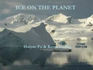
glacier -- A huge mass of ice slowly flowing over a land mass. The image below and left is of the Piedmont Glacier on Baffin Island, and the image below and right is of the Karakoram Region of north Pakistan.
butte -- A hill that rises abruptly from the surrounding area and has sloping sides and a flat top. I have visited Bear Butte in South Dakota and climbed to the top. It is considered very sacred ground by the Souix, and every caution is taken to remain on the marked trails out of respect for this site
mesa -- A broad, flat-topped elevation with one or more clifflike sides. Mesas like this one, are a common sight in northern Arizona and much of Utah
canyon -- A narrow chasm with steep cliff walls, cut into the earth by running water. Two famous canyons in the US are the Grand Canyon (lower right 3-D image) and Bryce Canyon (lower left ... photograph).
lake* -- A large inland body of fresh water or salt water. I thought this image of the Great Lakes was really cool.
basin* -- A large, bowl-shaped depression in the surface of the land, often drained by a single river (the Amazon Basin seen earlier in this page) or now from a mountaintop in Idaho
hill* -- a small elevation in the earth's surface. The rolling hills of eastern Washington serve as a nice picture
swamp -- A lowland region saturated with water. Swamps can be found in Minnesota, as readily as in Florida.
oasis -- A fertile or green spot in a desert or wasteland ... like this one in Egypt
desert -- an area with very little rainfall or vegetation. Here is a dramatic photograph from space of the desert of Afghanistan and Pakistan.
dune - how could the desert landform be on the list but the dune not? A dune is a hill or a ridge made of sand. Dunes are shaped by the wind, and change all the time.
steppe -- A vast grass-covered plain. While most think of the brutal steppes of Russia, this image of the steppes of Spain is just as descriptive