Oregon Explorer
Oregon Explorer. GEO 465/565 - Geographic Information Systems and Science Thursday, February 25, 2010 Kuuipo Walsh, Marc Rempel, Tyler Barns Institute for Natural Resources, OSU Libraries. www.oregonexplorer.info. Digital Library

Oregon Explorer
E N D
Presentation Transcript
Oregon Explorer GEO 465/565 - Geographic Information Systems and Science Thursday, February 25, 2010 Kuuipo Walsh, Marc Rempel, Tyler Barns Institute for Natural Resources, OSU Libraries www.oregonexplorer.info
Digital Library • Central access to information about Oregon’s natural resources • Information • Documents, Maps, Images, Tables • Stories: who, what, why • Provides access to this information in ways you cannot find anywhere else What is the Oregon Explorer?
Current Portals Portals in development Oregon Explorer portals Launch dates: Spring 2010
Most Popular Oregon Explorer Features Accessed and Usage Ave. # Visitor Sessions/day : 518 Total # of sessions since 11/06: 578K Note: Basin portal usage tracked separately GIS Mapping Tools Multi-media Stories Visualization & Reporting Tools Imagery Archived Documents Spatial Data
Who can use Oregon Explorer? • Educators • Students • Scientists • Researchers • Media staff • Citizen volunteers • Landowners • Interested public • Librarians • Natural resource decision-makers • Public agencies • Watershed council members • Local planners • Extension agents • Soil and water conservation district staff
Oregon Imagery Explorer: accessing .5 m Color Imagery “I'm delighted that recent aerial photo imagery is so easily available for the state, and in such a high resolution - thank you! The Oregon Imagery Explorer has made my project, and I'm sure that of many others, much easier.” - Student in the Botany and Plant Pathology Department, 1/26/2010
GIS Mapping Tools – “all natural issues are tied to place” 2002 needs assessment user response
Example of Oregon Explorer Output Map Carolyn Bales of Corvallis is a backpacker and bird watcher. She says she’s used the Willamette Basin Explorer a dozen times to plan outings and to locate access points to water where birds abound. “Oregon Explorer saves me from having to buy maps, and acquaints me with areas I might not have discovered otherwise,” she says.
How can Oregon Explorer increase understanding of natural resource issues?
Land Use Change – Measure 37 and 49 Viewers As a former member of the Corvallis Planning Commission and a courtesy faculty member in the geosciences department at OSU, Denis White has an interest in land use planning issues. He says that when he went to the Land Use Explorer site to check on Measure 37 claims near his home, he made some startling discoveries. “To my knowledge, the Measure 37 viewer on the site is the only place on the Web to get detailed maps and information about individual claims,” he says. “It’s a very useful resource.”
“Wildfire Risk In Your Area” tool: Community Name and Rating data layer Wildfire Risk Deschutes County example
Watershed Restoration Tool – Umpqua basin project report example
Oregon Communities Reporterrural & urban; incorporated & unincorporated Clusters: • Faye Stewart, a Lane County commissioner, says he’s impressed by the quality and quantity of demographic information he’s able to access on the Rural Communities Explorer. He’s able to glean valuable socioeconomic data for his district, as well as maps and geographic information. He says he especially appreciates the feature that allows him to hone in on areas of his district using aerial photos and apply overlays of land use designations and natural resources such as wetlands. “This is a powerful tool that will help me track trends in my district,” he says. “It also will be useful as we apply for block grants for facility upgrades.” • Population • Age • Family Structure • Education • Income • Employment & Labor Market • Migration • Race & Ethnicity • Health & Mortality • Crime & Abuse • Housing • Food System • Natural Resources & Amenities • Economic Resources • Environental Health • Community Capacity • Classifications
Oregon Explorer Program Contacts: • Marc Rempel marc.rempel@oregonstate.edu Oregon State University Libraries The Valley Library (541) 737-4744 • Kuuipo Walsh kuuipo.walsh@oregonstate.edu Institute for Natural Resources The Valley Library (541) 737-3795
What is a mashup? Mapping API (google maps, bing maps, etc) • a mashup is a web page or application that combines data or functionality from two or more external sources to create a new service. • The term mashup implies easy, fast integration, frequently using open APIs and data sources to produce results that were not the original reason for producing the raw source data. • Source: Wikipedia. Spatial Data Web application
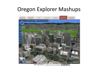
Oregon Explorer Mashups • Why Oregon Explorer uses mashups: • Focuses around a particular topic theme. • Engaging, interactive interface. • More flexibility in how to present maps and content.
Measure 37 Viewerhttp://oeapp.oregonexplorer.info/M37Viewer • Explores Measure 37 claims with the ability to overlay informational layers. • Virtual Earth/Bing Maps- JavaScript API • Overlay Web Map Service (WMS) from ArcIMS • Transparency slider, legend • Create active objects (pushpins, polygons). • Uses GET_FEATURES call to ArcIMS to draw polygons. • 3D Functionality.
ORWAP- Oregon Rapid Wetland Assessment Protocolhttp://oregonexplorer.info/wetlands/ORWAP/ • Creates a habitat sensitivity score for a selected point. • Uses ArcGIS server map and geometry services. • Buffers selected point and queries intersection of layers. • Uses Bing Maps JavaScript Extension for ArcGIS server.
Oregon Watershed Restoration Toolhttp://oregonexplorer.info/OregonRestorationVisTool/ • Displays restoration project information by basin and watershed councils. • ArcGIS Server 9.3.1 mapping backend • REST and SOAP used for getting layer data and overlaying WMS. • DOJO JavaScript class library for more interactive user interface.
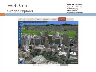
Components of Web GIS(to be continued in GEO 580) 1. Spatial Data • Shapefiles/ Geodatabases (ESRI) • KML/KMZ (Google Earth) • GeoRSS/GeoJson 2. Mapping Server • ArcIMS / ArcGIS Server • GeoServer • MapServer 3. Web servers • Apache Tomcat • IIS (windows) • 4. Mapping Application • ESRI WebADF/JS APIs • Google Maps API /ArcGIS Extension • Google Earth API • Bing Maps API /ArcGIS Extension • Bing Maps Silverlight API (Microsoft) • Flex (Adobe) / ArcGIS Extension • Yahoo Maps API • OpenLayers API • ArcGIS for iPhone API coming soon. • 5. Mapping Enhancements • JavaScript Class Libraries • Dojo, EXT.JS, YUI, jQuery
A simple web mapping application • Basic HTML and JavaScript will get you a long ways.
ESRI Resource Center http://resources.esri.com/arcgisserver/index.cfm?fa=home
For more information • On Oregon Explorer Mashups, contact: Marc G. Rempel - marc.rempel@oregonstate.edu • On Oregon Explorer Internships, contact: Tyler Barns - tyler.tmb30@gmail.com Kuuipo Walsh - kuuipo.walsh@oregonstate.edu