Download
1 / 32
340 likes | 569 Vues
Climate refers to the long-term weather patterns of a specific area, influenced by various factors such as latitude, geography, humidity, and elevation. Latitude plays a critical role, with tropical regions experiencing distinct wet and dry seasons, while temperate zones enjoy milder temperatures and diverse weather. The polar regions have extreme climates with long-lasting daylight. Geography, including bodies of water and mountains, also shapes climatic conditions, affecting precipitation patterns and temperature stability. Elevation significantly impacts climate, causing colder temperatures as altitude increases. ###

E N D
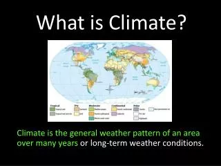
What is Climate? Climate is the general weather pattern of an area over many years or long-term weather conditions.
Factors Effecting Climate Although climate is most affected by latitude, it is also affected by geography (landforms), humidity, and altitude (elevation).
Climate & Latitude • As latitude changes, so does climate. • This is because the Sun heats the Earth unequally, due to Earth’s spherical shape.
The Low Latitude zone, or Tropical zone, is located between the Tropics of Cancer and Capricorn. • The sun hits the earth most directly here, creating the hottest region of the world. • Most regions of the Tropical zone have a dry season and a wet season. The wet season occurs during the summer, when most of the annual precipitation falls. The dry season is in the winter.
The Mid-Latitudes, or the Temperate zones are found between the Tropics and the Circles. • Temperatures here are generally more mild than in the Tropics. Warm air masses come from the Tropics during summer, and Cold air masses come from the Polar regions during the winter. • As a result, these areas have more diverse weather, vegetation, and bigger differences between seasons.
The High Latitudes, or the Polar regions, are located between the circles and the poles. • The two polar regions take turns getting continuous sunlight for 6 months. The North Polar Region receives daylight from March 20 to September 23, and the South Polar Region receives daylight for the rest of the year. A day in the polar regions literally lasts one year. • Obviously, cold temperatures and little vegetation is the norm here.
Latitude plays a huge role, if not the most important role in determining climate. For example, compare Antarctica and Saudi Arabia.
Precipitation • Wind Patterns • Ocean Currents As a result of latitude’s large control over temperature, latitude also determines:
Landforms and Climate • Climates even at the same latitude can be very different, as landforms such as bodies of water and mountains have a huge impact on climate. • For example, large bodies of water heat or cool slowly, making water temperatures more stable than land temperatures. This makes the coastal lands have more stable weather than that of inland areas. Water has stable temperatures. Makes coastal lands have stable temperatures and weather too.
• Mountains have a large impact on climate as well, by using orographic lifting to take precipitation from the incoming air masses, denying the neighboring land any rain. This phenomenon is known as the rain shadow effect. • Not only do landforms affect climate, but climate also has an effect on landforms, such as winds eroding a mountain. Precipitation, wind, temperature, and other statistics of climate can create or destroy landforms. Dunes are created by wind carrying and depositing sediment. Rock formed by wind and rain erosion.
• Landform breezes are common in the mountainous or hilly areas. Resulting from the higher slopes heating and cooling faster than the valleys. • During the day, the high slopes heat faster than the valleys, creating low pressure. This draws a breeze from the valleys, because air moves from high pressure to low pressure. • At night, the high slopes begin to cool faster, getting high pressure, so breezes flow from the highlands to the valleys. Day Heat/cools faster Night Heat/cools slower
What’s on the land is important too. Deserts, for example, have little moisture, so rain rarely occurs. Or, in the Tundra, it would be too cold for evaporation, also limiting precipitation. • The location of landforms are another factor. Areas more inland typically receive less rain then the coastal area, simply because the air masses from the ocean already gave it all to the coastal areas. Most clouds die before they reach the inland areas. Costal areas get a lot of precipitation from the ocean. Ocean Coastal Inland
Climate and Elevation Quito, Ecuador is nearly on the Equator. It also lies in the Andes Mountains at an elevation of more than 9,000 feet (2,743 meters). Average temperatures are about 32°F (17°C) cooler than the lowlands around it. · Elevation is how high above sea level you are. · It influences climate at all latitudes.
Climate and Elevation · Elevation can cause significant differences in climate (although this varies in different locations). · The effects of elevation on climate follow a general pattern. For example, the climate in the Andes Mountains will be similar to the climate in the Alps. Andes Mountains Alps
· Elevation influences climate because of the relationship between the elevation of a place and its temperature. · The higher you are, the less dense the air is (thinner air). Less dense air does not hold heat well. Therefore, the higher you are, the colder it is. In mathematical terms: · The temperature decreases by about 3.5°F to 4°F for every 1,000 feet (305 meters) increased. · 1 mile of elevation gained is equal to 800 miles of latitude gained. Elevation Affects Climate…Why?
What are “life zones”? They are groups and areas of similar vegetation and climate. Elevation and Life Zones At different elevation levels, there are different types of vegetation. The different life zones of an area depend on several factors such as soil type and the distance that area is from the sea.
Elevation and Temperature It is colder at higher elevations. This is caused by low atmospheric pressure. There is less air pushing down, so the air molecules spread out and lose energy. Even though it is closer to the sun, because of the thinner atmosphere (or air), the climate is colder.
Wind · Because there is low air pressure and few obstructions, high altitudes face high winds. · For every mile of elevation, wind speeds are increased by 8 miles per hour. · High winds cause less plant growth (including large trees). Many mountains have “tree lines”. A tree line is a border between lower elevation life zones (where trees live) and higher elevation life zones (winds are too rapid). Elevation and
High elevation areas have their own life zones. They also affect the climate of surrounding low elevation areas. Mountains block the movement of moist air from bodies of water. Their melting snow creates available water and climates below that contrast with the seasons. The inconsistent geography of mountain peaks cause many micro-climates. Climate and Mountains
Why is precipitation more frequent at high elevations? Air that is forced up a mountainside cools rapidly. Evaporated water in the air then condenses, creating clouds and rain. This process is known as orographic precipitation. Elevation and Precipitation
Rain Shadow Effect Important Terms Mountainsides to Know: · Windward Side: Facing the wind. · Leeward Side or Downwind Side: Not facing the wind.
Rain Shadow Effect: the Complicated Version Winds that blow over an ocean push upward at mountain ranges (which act as barriers to the flow of air across the surface of the Earth). Rising air cools and releases most of the moisture in the form of precipitation (large clouds and thunderstorms may form) on the windward mountain side. As the parcel of air descends on the leeward mountain side, it is dry. The area of dry land on the leeward side of the mountain is called a rain shadow.
Rain Shadow Effect: the Simple Version Key Points to Know: · Warm air can hold more moisture than cold air can. · Warm air is lifted on the windward side. · As it rises, it cools. · Moisture is squeezed out of the air. · Dry air descends on the leeward side. · Windward side is wetter. · Leeward side is drier. · Drier area/side is called the rain shadow.
Rain Shadow Effect Is… …also known as the orographic effect or orographic lifting. This process keeps windward sides of mountain ranges moist and filled with vegetation but leeward sides dry and barren. …the primary cause of dry areas such as deserts on the leeward mountain side.
City of Spokane (receives little rainfall) Cascade Mountain Range Seattle, Washington (receives generous amounts of rainfall)
Gobi Desert Himalayas
Patagonia Atacama Desert Andes Mountains
Death Valley Sierra Nevada Mountains Pacific Coast Ranges