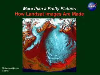
Landsat's Vital Role in Monitoring Global Ecosystem Changes
230 likes | 324 Vues
Landsat is pivotal in NASA's Earth studies, monitoring changes in ecosystems, climate dynamics, water, energy budgets, and Earth's carbon cycle. With precise data, it helps predict, assess, and respond to natural and human-induced alterations, impacting human civilization. Explore Landsat's critical role in understanding and predicting global environmental changes.

Landsat's Vital Role in Monitoring Global Ecosystem Changes
E N D
Presentation Transcript
NASA’s Earth Science Research Questions • How is the global Earth system changing? • What are the primary causes of change in the Earth System? • How does the Earth system respond to natural and human-induced changes? • What are the consequences of change in the Earth systems for human civilization? • How can we predict future changes in the Earth system?
Landsat Science Themes Together with other Earth Observing Satellite instruments, Landsat plays a critical role in NASA’s studies of Earth. A cornerstone of NASA’s Global Change Research: • Monitoring Ecosystem Changes • Climate Dynamics • Quantifying Water and Energy Budgets • Quantifying Earth’s Carbon Cycle
Monitoring Ecosystem Changes • NASA Earth Science Questions with Respect to Ecosystems: • How are global ecosystems changing? • How do ecosystems respond to and affect global environmental change and the carbon cycle? Although Climate Change is a global phenomenon… … the effects of climate change on ecosystems are local and heterogeneous - treeline/ecotone changes - invasive species - desertification - coral reef declines, etc.
Forest fragmentation in Amazon basin Mapping Spotted Owl Habitat, Oregon Coastal Marsh Loss in the Eastern U.S. Loss of Mesopotamian Wetlands Mapping extent and morphology of coral reefs Monitoring Ecosystem Changes
1973-76 2000 Monitoring Ecosystem Changes Gradual changes require long-term, repeat satellite coverage • Landsat data are used to: • Precisely assess the area affected • Separate human from natural causes • Bridge the gap between field observations and global monitoring Loss of wetlands in Mesopotamia (dark red areas) since 1973 from Landsat. Courtesy Hassan Partow, UNEP
Monitoring Ecosystem Changes Ecosystem disturbance and invasive species may be harbingers of climate change Example: Eastern Hemlock Decline Ridge & Valley Highlands Piedmont D. Royle and R. Lathrop, Rutgers University
April 14, 2000 Before Fire May 9, 2000 During Fire June 17, 2000 After Fire Monitoring Ecosystem Changes • Landsat is well suited to providing detailed maps of burned areas and for verification of coarse scale operational burn-scar mapping. A ratio of Landsat bands 4 and 7 is also used to create burn severity maps which are key in the post-fire rapid assessment process led by the Burn Area Emergency Response (BAER) Team. Cerro Grande Fire, New Mexico Courtesy U.S. Forest Service
Monitoring Ecosystem Changes • Climate Dynamics • Quantifying Water and Energy Budgets • Quantifying Earth’s Carbon Cycle
MODIS, AVHRR SeaWiFS Landsat Regional Land-cover and surface properties Global Surface Properties Regional Climate Analyses Global Climate Models Mesoscale Models Landsat and Climate Modeling Global Climate and Weather
Example: Climate and Land-Cover Change Do changes in landscape structure affect regional climate? Pre-1900 Vegetation 1990’s Land Cover from Landsat
Monitoring Ecosystem Changes • Climate Dynamics • Quantifying Water and Energy Budgets • Quantifying Earth’s Carbon Cycle
Quantifying Water and Energy Budgets Will future water supplies meet human needs? 1973 ARAL SEA • By 2025, 48% of global population will live in “water stressed” basins (<1700 m3/pers/yr) 1987 2000 Water flux into the Aral Sea is being diverted for human use Courtesy WRI
Quantifying Water and Energy Budgets What changes are occurring in the mass of the Earth's ice cover? Mountain Glacier Dynamics Franz Josef Glacier, New Zealand Most mountain glaciers worldwide have been retreating Pasterze Glacier, Austria06-Sept-1999 D. Hall, NASA GSFC
Quantifying Water and Energy Budgets Antarctic Monitoring Landsat Archive R. Bindschadler, NASA GSFC
LDCM Science Themes Together with other Earth Observing Satellite instruments, Landsat plays a critical role in NASA’s studies of Earth: • Monitoring Ecosystem Changes • Climate Dynamics • Quantifying Water and Energy Budgets • Quantifying Earth’s Carbon Cycle
375 Atmospheric CO2 350 325 ppm 300 275 250 1000 1200 1400 1600 1800 2000 year( AD) Quantifying Earth’s Carbon Cycle • Increasing atmospheric CO2 levels are correlated with increasing global temperatures • “How well can cycling of carbon through the earth system be modeled, and how reliable are predictions of future atmospheric concentrations of carbon dioxide and methane by these models?”
5.5 +/- 0.5 Reforestation Pg C / yr 1.6 +/- 1.0 Fire Supression 1.9 Woody Encroachment 2.0 +/- 0.8 CO2, N Fertilization 3.2 +/- 0.2 Climate Carbon Sources and Sinks 8 Emissions from Fossil Fuels Net release from land-use change Unidentified sink Oceanic uptake Atmospheric accumulation 6 Source 4 2 0 -2 Sinks -4 -6 -8 1850 1870 1890 1910 1930 1950 1970 1990 Human-induced Carbon Flux since 1850: where has all the carbon gone? source: WHRC
The Landsat Mission • Over 30-year years of global land cover data • Resolution shows human activities • Key information for climate, ecosystems, biogeochemical cycles, and hydrology studies EPA-USGS NALC Land-cover Dataset
Landsat-1 (ERTS) Landsat-2 Landsat-3 Landsat-4 Landsat-5 Landsat-6 Landsat-7 Landsat – 30 Years of Earth Observations MSS (79 m, 4 band) TM (30/120 m, 7 band) ETM+ (15/30/60 m, 8 band) LDCM LDCM Sensor (15/30/90 m, 9 band 1990 1970 1980 2000 2010 Commercial operations Government operations
Landsat-7 Global Acquisitions The first truly global archive
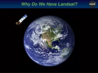
Landsat Data Continuity Mission Extending the Legacy of Global Land Observations The Landsat Data Continuity Mission (aka LDCM) will continue the legacy of the Landsat program. Launch dates are years away, and the request for proposals for the instrument is to be released soon. For more information on the next satellite in the Landsat series, please visit http://ldcm.gsfc.nasa.gov
National Aeronautics and Space Administration http://www.nasa.gov