
% Roads in poor condition
Using Cartographic Maps to Facilitate Data Appreciation for the Spatially Challenged. Ashraf Ghaly, Professor of Engineering, Union College, Schenectady, NY. % Roads in poor condition. $ Repair cost/motorist/year. % Structurally deficient bridges. % Congested roads.

% Roads in poor condition
E N D
Presentation Transcript
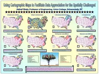
Using Cartographic Maps to Facilitate Data Appreciation for the Spatially Challenged Ashraf Ghaly, Professor of Engineering, Union College, Schenectady, NY % Roads in poor condition $ Repair cost/motorist/year % Structurally deficient bridges % Congested roads Americans traveled 2.85 trillion vehicle-miles in 2002. While highway mileage is mostly rural, a majority of road travel (60%) occurred in urban areas in 2002. As vehicle-miles traveled continues to increase for all vehicles, it increased at a greater rate for commercial trucks, which has caused increased wear and tear on roads and bridges throughout the United States. Poor road conditions cost U.S. motorists $54 billion a year in repairs and operating costs—$275 per motorist. Americans spend 3.5 billion hours a year stuck in traffic, at a cost of $63.2 billion a year to the economy. Total spending of $59.4 billion annually is well below the $94 billion needed annually to improve transportation infrastructure conditions nationally. “[27.1%] of the nation’s 590750 bridges [are] rated structurally deficient or functionally obsolete”. A structurally deficient bridge is closed or restricted to light vehicles because of its deteriorated structural components. While not necessarily unsafe, these bridges must have limits for speed and weight. A functionally obsolete bridge has older design features and, while it is not unsafe for all vehicles, it cannot safely accommodate current traffic volumes, and vehicle sizes and weights. More than 67% of peak hour traffic occurs in congested conditions. The cost to the economy—in wasted time and fuel—in the 85 largest urban areas is $63.2 billion each year. In addition, poor highway conditions hinder the effective transport of goods that help support the American economy. Number of deficient dams Number of high hazard dams Drinking water needs ($Billion) Wastewater needs ($Billions) Historically, some of the largest disasters in the United States have resulted from dam failures. In 1889, 2,209 lives were lost when the South Fork Dam failed above Johnstown, Pennsylvania. The 1928 St. Francis Dam failure killed 450. During the 1970s, the failures of the Buffalo Creek Dam in West Virginia, Teton Dam in Idaho and the Toccoa Falls Dam in Georgia collectively cost 175 lives and more than $1 billion in losses. Such dam failures as Silver Lake Dam in Michigan in 2003 ($100 million in damages and economic losses of $1 million per day) and the Big Bay Lake Dam in Mississippi in March 2004 (100 homes destroyed) are reminders of the potential consequences of unsafe dams. The number of high hazard potential dams (dams whose failure would cause loss of human life) is increasing dramatically. Since 1998, the number of high hazard potential dams has increased from 9,281 to 10,213. As downstream land development increases, so will the number of high hazard potential dams. As these dams often require major repair to accommodate more stringent inspection, maintenance and design standards, financial support for state dam safety programs must keep pace. America faces a shortfall of $11 billion annually to replace aging facilities and comply with safe drinking water regulations. Federal funding for drinking water in 2005 remained level at $850 million, less than 10% of the total national requirement. Aging wastewater management systems discharge billions of gallons of untreated sewage into U.S. surface waters each year. The EPA estimates that the nation must invest $390 billion over the next 20 years to replace existing systems and build new ones to meet increasing demands. % Deficient schools % Environmentally deficient schools • ASCE Report Card • Aviation (D+), • Bridges (C), • Dams (D), • Drinking Water (D-), • Energy (D), • Hazardous Waste (D), • Navigable Waterways (D-), • Public Parks (C-), • Rail (C-), • Roads (D), • Schools (D), • Solid Waste (C+), • Transit (D+), • Wastewater (D-), • Cumulative grade is (D). Abstract If a picture is worth a thousand words, a map is probably worth a million words. This is generally true for those with trained eyes and minds who can look at a map and appreciate the data it displays. Those who are spatially challenged, however, no matter how clear the message a map illustrates, they seem unable to comprehend the meaning behind the data. An effective way of displaying data in a much clearer fashion is to proportion features such as points, lines, or polygons to a certain phenomenon that will sharpen focus on one or more factors. In addition to other variations that GIS software packages make available, size variation compounds the desired effect and leaves a stronger impression on map viewers. This presentation will show how cartographic maps can be used to illustrate the scope and depth of issues related to America’s infrastructure. The examples that will be used are related to roads, bridges, dams, drinking water, wastewater, parks, the environment, and transit and energy facilities. This approach has been used in teaching students with limited or no background in GIS and was received with enthusiasm and fascination. It effectively allowed the students to appreciate the extent of the problems faced by the states of the union in addressing infrastructure needs. The map shows percentage of schools with at least one deficient building. The Federal government has not assessed the condition of America’s schools since 1999, when it estimated that $127 billion was needed to bring facilities to good condition. Other sources have since reported a need as high as $268 billion. The map shows percentage of schools with at least one environmentally deficient building. Given that children are the future, it is believed that governments at all levels should make primary and secondary education a priority, and should provide the resources to support the necessary infrastructure.