Download
1 / 36
360 likes | 495 Vues
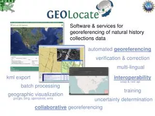
Software & services for georeferencing of natural history collections data. automated georeferencing. verification & correction. multi-lingual. kml export. interoperability. soap & rest api. batch processing. training. geographic visualization. uncertainty determination.

E N D
Software & services for georeferencing of natural history collections data automated georeferencing verification & correction multi-lingual kml export interoperability soap & rest api batch processing training geographic visualization uncertainty determination google, bing, openstreet, wms collaborative georeferencing
What is Georeferencing pushepatapa creek, trib. to pearl river, 7.8 miles north of bogalusa at hwy 21; Washington; LA; USA latitude: 30.88797longitude: -89.83601 uncertainty radius: 48muncertainty polygon: 30.88823,-89.83641, 30.88815,-89.83634, 30.88808,-89.83622…
pushepatapa creek, trib. to pearl river, 7.8 miles north of bogalusa at hwy 21; Washington; LA; USA Typical Workflow DataPreparation AutomatedProcessing Automated Georeferencing Verification/adjustment of output coordinates & uncertainties Human Participation latitude: 30.88797longitude: -89.83601uncertainty radius: 48muncertainty polygon: 30.88823,-89.83641, 30.88815,-89.83634, 30.88808,-89.83622…
Representation of Uncertainty Eagle Lake,Warren County,Mississippi, USA
Uncertainty within GEOLocate Point radius and polygonal uncertainties Point radius represented as a distance in meters fromgeoreferenced point Polygons represented as a comma delimited array of vertices using latitude and longitude Supports auto-detection and generation of polygons (web app only, in development for desktop app)
Homochitto National Forest; MS; USA Along Highway 84
A Framework for Collaborative Georeferencing DiGIR Service Remote Data Source CSV Upload Cache Update Web Service • CoGe Web Portal Application Data Retrieval Web Service Data Store • CoGe Client Application (Desktop or Web) Record Processor Insert Correction Web Service Georeferencing Web Service
Georeferencing Communities CreateCommunities Data Sources Add New Users & Link Out
Georeferencing Communities Data Sources
User Management: Task Assignment Assign all records from Kenya to experts on East African regions
Collaborative Web Client Optional Hyperlink
Interoperability Embeddable Web Client Georeferencing Web Services
Georeferencing Services:GEOLocate v2 http://www.museum.tulane.edu/webservices/geolocatesvcv2/geolocatesvc.asmx SOAP & HTTP Get/Post
HTTP/1.1 200 OK Content-Type: text/xml; charset=utf-8 Content-Length: length <?xml version="1.0" encoding="utf-8"?> <Georef_Result_Setxmlns="http://www.museum.tulane.edu/webservices/"> <EngineVersion>string</EngineVersion> <NumResults>int</NumResults> <ExecutionTimems>double</ExecutionTimems> <ResultSet> <WGS84Coordinate> <Latitude>double</Latitude> <Longitude>double</Longitude> </WGS84Coordinate> <ParsePattern>string</ParsePattern> <Precision>string</Precision> <Score>int</Score> <UncertaintyRadiusMeters>string</UncertaintyRadiusMeters> <UncertaintyPolygon>string</UncertaintyPolygon> <ReferenceLocation>string</ReferenceLocation> <DisplacedDistanceMiles>double</DisplacedDistanceMiles> <DisplacedHeadingDegrees>double</DisplacedHeadingDegrees> <Debug>string</Debug> </ResultSet> <ResultSet> . . . </ResultSet> </Georef_Result_Set> Version 2 Get Response georef2()
Application Service:Embeddable Client • Lightweight web based client, specifically designed for embedding into other web applications. • Requires JavaScript postMessage – compatible with all modern browsers. • Internet Explorer 8.0+ • Firefox 3.0+ • Safari 4.0+ • Google Chrome 1.0+ • Opera 9.5+
Excel http://www.museum.tulane.edu/geolocate/web/WebGeoref.aspx?v=1&Country=USA&State=LA&County=Washington&Locality=Bogalusa&georef=run
Future Work: Broad Crowdsourcing Paynes Prairie Preserve State Park, near Gainesville. Alachua; FL; USA Clustering based upon spatial variance, uncertainties & user skill level.