Download
1 / 32
360 likes | 888 Vues
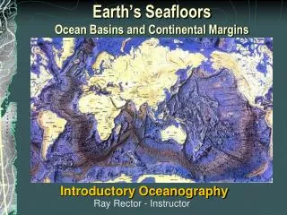
Chapter 4 Continental Margins and Ocean Basins. Bathymetry of Sea Floor Continental Margins and Ocean Basins Submarine Canyons Hydrothermal Vents Trenches. Bathymetry: a map of the ocean floor Early bathymetric studies were often performed using a weighted

E N D
Chapter 4 Continental Margins and Ocean Basins • Bathymetry of Sea Floor • Continental Margins and Ocean Basins • Submarine Canyons • Hydrothermal Vents • Trenches
Bathymetry: a map of the ocean floor Early bathymetric studies were often performed using a weighted line to measure the depth of the ocean floor. • Echo sounding • Multibeam Systems • Satellite Altimetry Vw ~= 1500 m/s (Pres, Temp, Salinity) Echo Sounders Bounce Sound off the Seabed
Review: Echo sounders sense the contour of the seafloor by beaming sound waves to the bottom and measuring the time required for the sound waves to bounce back to the ship. If the round-trip travel time and wave velocity are known, distance to the bottom can be calculated. This technique was first used on a large scale by the German research vessel Meteor in the 1920s.
LIDAR: Light Imaging Detection And Ranging Vw ~= 1500 m/s (Pres, Temp, Salinity) Va ~= 344 m/s (Pres, Temp, other)
Multi-beam echo sounder Using satellite measurements to map the ocean floor
Gravitational Anomalies:Bathymetry of ocean floor-ridges, shelves
Topography of Ocean Floors Cross section of the Atlantic ocean basin and the continental United States, showing the range of elevations. Ocean depth is clearly greater than the average height of the continent, but general range of contours is similar.
Deep-ocean basin Continental margin Continental margin Submarine canyon profile (cut through continental shelf) Sediment Continental shelf Continental slope Oceanic ridge Sediment Continental rise Continental crust (granitic) Continental crust (granitic) Oceanic crust (basaltic) Oceanic crust (basaltic) Asthenosphere
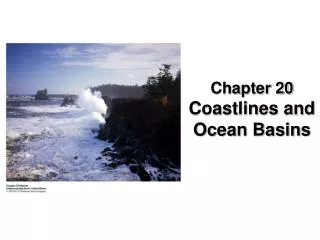
Narrow continental shelf An active margin A passive margin Peru–Chile Trench Plate boundary Andes Mountains Plate boundary Broad continental shelf South America Atlantic Ocean Pacific Ocean South American Plate Deep basin Nazca Plate African Plate Plate movement Plate movement Plate movement Subduction zone (deep and shallow earthquakes) Mid-Atlantic Ridge (spreading centers, shallow earthquakes) • Atlantic = Passive Margin • little/no geologic activity • Pacific = Active Margin • geologic activity
The ocean floor can be classified as (a) Continental Margins – the submerged outer edge of a continent (b) Ocean Basin – the deep seafloor beyond the continental margin There are two types of continental Margins (a)passive or trailing margins: margin of continent that moves away from spreading center – Atlantic-style margins (also Artic Ocean, Antarctica and Indian Ocean). Very little volcanic or earthquake activity is associated with passive margins. (b) active or leading margins: plate boundary located along a continental margin – ocean trenches where there is subduction of oceanic lithosphere – narrow, steep, with volcanic mountains (West Coast of the Americas). Active margins are the site of volcanic and earthquake activity.
Continental Margins • Region where continental crust meets oceanic crust • Continental Shelf • Shelf Break • Continental Slope • Continental Rise
Continental Shelves • Gently sloping (~0.5 degrees) • Depositional environments • Average width 65 km (40 miles) • Average depth 130 m (430 feet) • Narrow along Active margins • Wide along Passive margins
Continental Shelves: broad shallow extension of the continents (~75km wide) Regions of deposition (rivers, glaciers, scrapped marine deposits, calcium carbonate) Large bedform features, reworked by tides, storms, waves
Anatomy of a passive margin (~ 140 m) deep sediments accumulate here, thickness varies
Continental Margins • Shelf Break Edge of the continental shelf Change in slope • Continental Slope Extends from break to ocean basin Steep (3 – 6 degrees) As high as 25 degrees Little/no deposition
Continental Slopes: continental crust thins into oceanic crust steep (~20km, 1-25 degrees), 5deg Pacific, 3deg Atlantic extend to depths between 1500-4000 m
Submarine Canyons Form at the Junction between Continental Shelf and Continental Slope These are features of some continental margins. They cut into the continental shelf and slope, often terminating on the deep-sea floor in a fan-shaped wedge of sediment.
Submarine Canyon • Steep V shape channel, incised in the continental slope (and shelf) • Created by • Rivers during the last low stand (some) • Turbidity currents
Turbidity Currents • Fast moving avalanches of mud and sand scour slopes • Form turbidite deposits • 90 km/hr (56 mi/hr) Turbidite bedancient deposit, exposed to erosion, graded deposits: largest particles at bottom
Continental Margins • Continental Rise Base of the continental slope slope 0.5 – 1 degree Depositional environment Formed by: Turbidity currents Underwater landslides
Continental Rise: Fan like deposit where the continental slope intersects the abyssal plains Formed by turbidity currents
Features of the Sea floor • Oceanic Ridges • Hydrothermal Vents • Abyssal Plains and Abyssal Hills • Seamounts and Guyots • Trenches and Island Arcs • Seafloor: 4000 – 6000 m water depth, 30% of the Earth’s surface • Abyssal Plain: vast, flat plain extending from the base of the continental slope. • Ocean Basins: sections of the abyssal plain separated by continental margins, ridges, and rises.
sections of the abyssal plain separated by continental margins, ridges, and rises. Basins
Sea floor features Flat-topped seamounts eroded by wave action are called guyots. Abyssal hills are small, extinct volcanoes or rock intrusions near the oceanic ridges.
Seamounts are volcanic projections from the ocean floor that do not rise above sea level. Flat-topped seamounts eroded by wave action are called guyots Abyssal hills are flat areas of sediment-covered ocean floor found between the continental margins and oceanic ridges. Abyssal hills are small, extinct volcanoes or rock intrusions near the oceanic ridges.
Hydrothermal vents are sites where superheated water containing dissolved minerals and gases escapes through fissures, or vents. Cool water (blue arrows) is heated as it descends toward the hot magma chamber, leaching sulfur, iron, copper, zinc, and other materials from the surrounding rocks. The heated water (red arrows) returning to the surface carries these elements upward, discharging them at hydrothermal springs on the seafloor. http://www.divediscover.whoi.edu/vents/index.html
Mid-Ocean Ridges and Rises An oceanic ridge is a mountainous chain of young, basaltic rock at an active spreading center of an ocean.
Major ocean trenches Trenches are arc-shaped depressions in the ocean floor caused by the subduction of a converging ocean plate. Most trenches are around the edges of the active Pacific. Trenches are the deepest places in Earth’s crust, 3 to 6 kilometers (1.9 to 3.7 miles) deeper than the adjacent basin floor. The ocean’s greatest depth is the Mariana Trench where the depth reaches 11,022 meters (36,163 miles) below sea level.
Same scale for comparison ‘real’ scale – no exaggeration
Chapter 4 - Summary • Bathymetric devices used to study seabed features include multibeam echo sounder systems and satellites that use sensitive radar for altimetry. • Seafloor features result from a combination of tectonic activity and the processes of erosion and deposition. • Near shore, the features of the ocean floor are similar to those of the adjacent continents because they share the same granitic basement. The transition to basalt marks the edge of the continent and divides ocean floors into two major provinces, The submerged outer edge of a continent is called the continental margin. The deep-sea floor beyond the continental margin is called the ocean basin • Features of the continental margins include continental shelves, continental slopes, submarine canyons, and continental rises. • Features of the deep-ocean basins include oceanic ridges, hydrothermal vents, abyssal plains and hills, seamounts, guyots, trenches, and island arcs.