Download

1 / 32
320 likes | 507 Vues
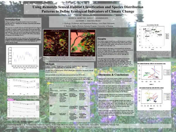
Introduction to Classification of Remotely Sensed Imagery. John Porter. Example – Thematic Mapper. The Thematic Mapper is a satellite sensor used in recent LANDSAT satellites It captures 7 bands ~30 m spatial resolution for bands 1-5 &7, ~120 m in band 6 Extent:.

E N D
Introduction to Classification of Remotely Sensed Imagery John Porter
Example – Thematic Mapper • The Thematic Mapper is a satellite sensor used in recent LANDSAT satellites • It captures 7 bands • ~30 m spatial resolution for bands 1-5 &7, ~120 m in band 6 • Extent:
Thematic Mapper Spectral Bands Wavelengths in micrometers Band 1 = 0.45-0.52 Band 2 = 0.52-0.60 Band 3 = 0.63-0.69 Band 4 = 0.76-0.90 Band 5 = 1.55-1.75 Band 6 = 10.40-12.50 Band 7 = 2.08-2.35
Geometric Correction Radiometric Correction Recoding Classification Raster GIS Data Layer Raster to Vector Conversion Polygon GIS Data Layer Remote Sensing to GIS Raw Image
Geometric Correction Remote Sensing to GIS Classification Raw Image Sometimes steps are omitted or reordered, depending on the purpose of the analysis Raster GIS Data Layer
Automated Image Processing • This lecture will focus on automated image processing: • Unsupervised Classification • Supervised Classification • Tools for Image Processing
Classification • Classification is the process of taking the “brightness values” associated with each pixel and using them into assign a class to the corresponding output pixels • Output pixels are NOT continuous. Instead they are discrete values that represent a class or category (e.g. land cover classes) • For example, we might decide that pixels with the value (20,30,190) (in band 1 thru 3 , respectively) indicate that the output pixel should be assigned a value of “10” – corresponding to class “10”=forest
Classification • The trick in classification is to come up with “rules” that will allow us to translate image values (e.g., 10,20,190) into classes (forest, grass, water, marsh, urban) • Usually the land cover classes are associated with numerical codes: e.g., 1=forest, 2=grass, 3=water, 4=urban
Classification Methods • There are two fundamental approaches to classification: • Unsupervised • The computer selects classes based on clustering of brightness values • Supervised • You specify the classes to be used and provide “signatures” for each class
Unsupervised Classification • Unsupervised classification refers to a variety of different techniques that share some features in common • They use statistical “clustering” techniques to decide which pixels should be grouped together • With luck, these clusters of pixels will correspond to land cover classes • But the correspondence may not be 1:1 • One land cover class may be represented by more than one cluster (easily fixed by recoding) • One cluster may represent more than one land cover type (not easily fixed – may need to specify more clusters)
Example • The “Image Analyst” extension in ArcView uses the ISODATA unsupervised clustering technique where all you need to specify is the number of desired classes
Each color represents a different “cluster” pixels that may correspond to the land cover classes you are interested in
Recoding • Following an unsupervised classification, you need to go through and assign “meaning” to each of the classes (e.g., class 1 = water) • You can use editing functions to set multiple classes that represent the same land cover type to a common value • E.g., if both class 1 and class 5 are water (albeit, deep water vs. shallow water), you may want to edit all the 5’s and change them to 1’s
Supervised Classification • In supervised classification you help the computer to select “signatures” that represent each land cover class • Signatures are statistical descriptions of the brightness values of a given land cover type (e.g., the mean band 1 value, the mean band 2 value etc.) • You select signatures using a tool that provides “seed” values
Signature Selection • The key to a good supervised classification is proper selection of “signatures” • What makes for a good signature? • Characterizes a land cover type of interest • Separability – needs to be distinguishable from other signatures
Collecting Signatures • There are two main methods for obtaining signatures • Area-based – where you use a box on the screen to select the area to be statistically characterized as a signature • Growing an area – where you select a point and other “similar” adjacent points are added to the sample • Note: choice of minimum similarity can have a big effect on the results of this method
Used the “seed tool” and clicked here. The highlighted marsh area was similar in color and connected to the point so it was added to the data used to calculate the signature.
The “Find Like Areas” command highlighted all the other areas that have a similar color (i.e. similar spectral values) – with skill they will all be Marsh
The process is repeated to add new classes Due to color variations within a class, often multiple signatures will be needed to capture a single cover class The classes can be recoded and lumped (using basic editing functions) so that they correspond to the desired classes. But not all water was “captured” by the class- requiring additional “signatures” Classification Added Water
Classification • Once you have a group of signatures defined, you can classify your image. There are several methods for doing this: • Paralleliped • Mahalanobis Distance • Maximum Likelihood • And others……….
Paralleliped Classification • use maximum and minimum values on each individual band (as derived from each signature) to decide which pixels fall within a given class • Advantages • Fast • Can be used one signature at a time • Used by ARCVIEW Image Analyst • Disadvantages • Does poorer job separating classes • Uses only a fraction of the information contained in the signature data
Maximum Likelihood • Uses statistical techniques to decide which class a pixel falls into • Advantages • Uses full signature information (mean, variation & inter-band covariation) to tease apart similar classes • Disadvantages • More computer intensive • Not available in ARCVIEW
We can use a graph to display where pixels fall on two bands at once 255 Pixel bright on both bands Band 2 Pixel dim on both bands 0 255 0 Band 1 Graphical Description Pixel dim on band 1, but bright on band 2
Here is a sample display where Marsh is dark, beach is light on both bands and water is bright on one band (presumably blue) and dim on the other 255 Band 2 0 255 0 Band 1 Graphical Display Water Beach Marsh
Paralleliped classification uses boxes based on statistical measures of the range (e.g. maximum and minimum values) 255 Band 2 0 255 0 Band 1 Paralleliped Here, paralleliped would work well Min. on band 1 Max on band 1
However, sometimes paralleliped may do a poor job separating classes Paralleliped Areas of overlap lead to uncertain results 255 Band 2 0 255 0 Band 1
Maximum likelihood uses seed statistics to define ellipses for each class 255 Band 2 0 255 0 Band 1 Maximum Likelihood
Ellipses make it easier to separate similar classes Maximum Likelihood 255 Band 2 0 255 0 Band 1
Software for Image Classification • ArcView Image Analyst • Provides basic image classification capabilities • Unsupervised: ISODATA method • Supervised: Paralleliped only • Also supports georeferencing and some image processing (e.g., sharpen edges) • Relatively easy to use
Software • ERDAS Imagine • Full suite of advanced image processing and classification features • Unsupervised: many different clustering techniques available (including ISODATA) • Supervised: better tools for capturing and analyzing signatures, many classification methods (including paralleliped and maximum likelihood) • Harder to use (with power comes complexity)