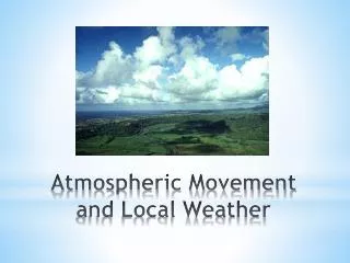
Local Weather Systems
This text explores the fundamental processes of weather, focusing on air masses, cloud formation, and different types of precipitation. It explains how solar radiation heats the ground, causing warm air to rise and cool. Key types of clouds—cumulus, stratus, and cirrus—are introduced, alongside their formation processes and characteristics. The classification of precipitation, including rain, snow, sleet, and hail, is discussed, detailing how temperature influences droplet and crystal formation. Additionally, the text covers the dynamics of various fronts and their impacts on weather patterns.

Local Weather Systems
E N D
Presentation Transcript
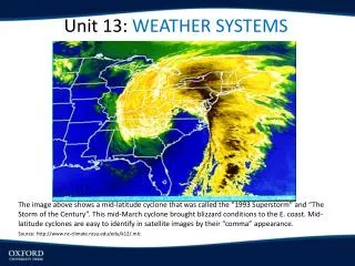
Local Weather Systems Ch 15 SciencePower 10
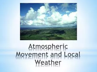
Lifting Mechanisms for Air (text p. 488) • Solar radiation heats ground, ground heats air by conduction, warm air expands and rises • Two air masses of different temperatures meet cooler mass slides under warmer mass pushing it higher up where it then begins to cool • Moving air mass meets mountain range, rises to cross mountains, expands and cools, often reaching dew point temperature
If the ground is very cool, the air above is cooled by contact. Ground continues to cool by emitting IR (infrared) radiation. Air cools to dew point and clouds or fog forms
Cloud Shapes • Three main shapes- cumulus, stratus, cirrus • Cumulus refers to puffy or billowy • Stratus means layered • Cirrus refers to thin, whispy,
Cloud Shapes continued • Stratus clouds may form when air masses meet, when air is pushed up a mountain range, or when conduction takes place with a cool ground suface. • Fog is a stratus cloud • Radiation fog when rapid cooling of the ground results in the air reaching dew point and condensing.
Cloud Shapes continued • If there is very little water vapour in the air, dew point temperature is low and air must rise very high to cool sufficiently to dew point temperature. Water vapour undergoes a phase change directly to solid ice crystals (deposition). • Cirrus clouds made up of ice crystals • Clouds often have features that are a combination of the three shapes and they are named as such e.g. cirrocumulus
Rain or snow clouds have the word nimbus included e.g. cumulonimbus, nimbostratus
Formation of raindrops • Size of water droplets in clouds determine type of precipitation we get. • Average water droplet ≈ 0.02 mm needs to be 0.5 mm to fall. Avg raindrop ≈2 mm • Cloud droplets almost always in motion due to air currents-they coalesce and blend together forming raindrops • In temperate climates e.g. Canada, raindrops start out as snowflakes which in turn begin as ice crystals. Water vapour deposits on ice crystals which collide with other crystals an stick together forming snowflakes. The snowflakes melt into raindrops as they fall through warmer air.
Rain, Snow, Sleet, Hail (text p. 494) • If the air below the clouds is below freezing all the way to the ground, the ice crystals in the clouds stay in the form of snow. If the air is very cold, crystals remain small (like powdery snow). If the air is warmer but still below freezing, crystals stick together and form larger snowflakes. If air near ground is cold enough, raindrops freeze again into ice pellets called sleet. If the air is warm enough to allow rain to fall but ground and objects on ground are below freezing, rain freezes instantly on contact and can cause damage and dangerous driving conditions. Hail starts out as frozen raindrops but they are carried back up into clouds by wind currents, they collide with droplets in the air at or around freezing forming hailstones. Hail can cause serious damage to crops and property
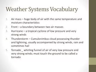
Highs, Lows, & Fronts • An air mass is a parcel of air that spends enough time over a region to take on the temperature and humidity of that region. Moving air masses interact and sometimes “fight” with each other. • The zone between air masses is a front. • The 4 types of fronts are: cold, warm, stationary, and occluded
Highs, Lows, & Fronts • A cold front is the zone where a moving cold air mass overtakes a warmer air mass. The denser cold air moves in below the warm air pushing it rapidly upward. A cumulus cloud forms. The water vapour in the rising air condenses releasing energy and slowing down the cooling of the rising air. If the rising and condensation continues, a cumulonimbus cloud forms and rain usually falls. While some cold air masses move slowly, others can travel at 100 km/h. This fast moving front normally causes intense thunderstorms often with hail and sometimes tornadoes. (see text p 497)
Highs, Lows, & Fronts • A warm front is created when a warm air mass overtakes a cooler one. The warm air gently rides up over the training end of the cold air mass (see p. 497). The zone of contact between the two masses is a gently slope. Stratus clouds usually form and cirrus clouds higher up.Nimbostratus clouds form close to the front bringing light rain or snow. The temperature is warmer after the warm front has passed.
Highs, Lows, & Fronts • A stationary front occurs when a cold and a warm air mass contact each other and neither moves. Some of the warm air rises and passes over the cold air. The rising air condenses forming stratus clouds and often rain. If the front remains in place for a few days,the result is a dreary, gloomy sky • An occluded front is created when a cold front catches up with a slow moving warm front, pushes it up and out of the way and meets the leading cold air mass. The cold front brings cumulus clouds while the warm front brings stratus and cirrus clouds. Occluded fronts often cause steady precipitation.
Highs, Lows, & Fronts • A high pressure system occurs where air is descending (i.e exerting more pressure on region below) • If an air mass forms over cold ground, conduction and convection cause the air above the ground to cool, become more dense and settle closer to the ground. This also increases air pressure. The high pressure system pushes air out toward the lower pressure area at the perimeter. In the Northern Hemisphere, this air curves to the right in all directions because of the Coriolis effect. This sets up a clockwise rotation of air called an anticyclone. High pressure systems form from cold descending air with little moisture hence no cloud formation.
Highs, Lows, & Fronts • A low pressure system forms when warmer air rises leaving behind less dense air. As the air rises, more air is pulled in beneath it. The Coriolis effect causes the air to curve to the right initiating rotation in a counterclockwise direction in the Northern Hemisphere. This forms a cyclone. Low pressure systems bring unstable conditions e.g. changing weather, precipitation and often storms.
Severe Weather • Thunderstorms • Tornadoes • Hurricanes • Monsoons
Severe Weather • 3 stages in the development of thunderstorms (p. 503) • 1. Cumulus cloud forms –warm air quickly rises • 2. Warm air condenses, latent energy released updraft created, droplets coalesce into snowflakes then rain which falls to Earth. Downdraft created as well as anvil shape at top. Charge separation occurs. Electrons at bottom, buildup of negative charge. Eventual discharge to ground as lightning. • 3. No more warm air drawn up, rain continues with downdraft.
Severe Weather • Tornadoes (see p. 505) • A swirling vortex of air • Wind speeds of 60 km/h to 500 km/h • 3 stages of development • 1. Small cyclones in thunderclouds intensified by wind shear i.e. blowing in different directions at different heights • 2. Lower pressure in centre of cyclone and below stretches cyclone which becomes narrower. Then spins faster. Wall cloud visible at base. • 3. Cyclone continues to stretch & spinning accelerates. Funnel cloud develops when touches ground it is classed as a tornado. • Fujita scale F0 to F5 based on wind speed and damage caused. • Tornado alley- Oklahoma, Kansas, Missouri
Severe Weather • Hurricanes • Larger more destructive tornado. May be 500 km wide. Swirling, roving thunderstorm. • Fueled by thermal energy of warm tropical ocean water • Need Coriolis effect to start spinning • Directly over equator Coriolis effect is absent. • Most hurricanes affecting North America start in the Atlantic west of Africa. Thunderclouds form, and are drawn together by updrafts fueled by water vapour from warm ocean water and energy released by condensation in clouds. Coriolis starts spinning. When winds reach 37 km/h storm is classed as a tropical depression. At 65 km/h it is a tropical storm. At 120 km/h it is a hurricane.
Severe Weather • Monsoons • Systems of winds bringing torrential rain and flooding in summer. Affects mainly Southern Asia because of position of the land and oceans. Intense heat in summer causes hot air to rise brings strond winds from Indian Ocean. Warm moist air generates strong rains and flooding. In winter, direct sunlight warms ocean, land cools, wind blows from land to sea. It is dry and a high pressure system from Siberia directs cold dry air toward southern Asia.