Sea Surface Temperature. MOD 28 Status
Sea Surface Temperature. MOD 28 Status . O. B. Brown, P. J. Minnett, R. H. Evans, E. J. Kearns & Viva Banzon, Warner Barringer, Jim Brown, Jennifer Hanafin, Erica Key, Kay Kilpatrick, Ajoy Kumar, Kevin Maillet, Goshka Szczodrak, Sue Walsh. Meteorology and Physical Oceanography

Sea Surface Temperature. MOD 28 Status
E N D
Presentation Transcript
Sea Surface Temperature.MOD 28 Status O. B. Brown, P. J. Minnett, R. H. Evans, E. J. Kearns & Viva Banzon, Warner Barringer, Jim Brown, Jennifer Hanafin, Erica Key, Kay Kilpatrick, Ajoy Kumar, Kevin Maillet, Goshka Szczodrak, Sue Walsh. Meteorology and Physical Oceanography Rosenstiel School of Marine and Atmospheric Science University of Miami MODIS Science Team Meeting Baltimore, 18 December, 2001
The need for validation The infrared bands of MODIS form self-calibrating radiometers. The retrieved SST fields are validated to confirm the procedures used to generate them from the radiometer data are performing as believed, i.e. it is the atmospheric correction algorithm that is being validated. This requires instrumental imperfections to beknownand the data corrected. The validation exercise provides a determination of the accuracy characteristics of the derived fields.
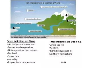
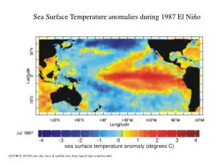
ESE Relevance:Decadal SST trends Based on conventional measurements over ~5 decades. Signals are such that if satellite SST’s are accurate to ~0.2K, signals should be detectable over a couple of decades. From: Casey, K. S. and P. Cornillon (2001). "Global and Regional Sea Surface Temperature Trends." Journal of Climate14: 3801–3818.
MODIS TERRA NIGHTTIME 11μm SST MAY 2001 V 3.3.1 -2 5 10 15 20 25 30 35 oC MODIS/OCEAN GROUP GSFC, RSMAS
SST Animation • Seasonal migration • Tropical Instability Waves • Monsoon effects in Arabian Sea • Warm water entering Arctic by Norway • Gulf Stream…..
What is SST? – the skin vs. bulk debate The optical depth of sea water at infrared wavelengths is < 1mm. The source of the MODIS signal in the atmospheric windows is the skin layer of the ocean, which is generally cooler than the subsurface layer because of heat flow from the ocean to the atmosphere. The conventional meaning of SST is the temperature measured at a depth of a meter or more by a contact thermometer; the so-called bulk temperature. At the levels of accuracy at which SST needs to be measured for MODIS, skin and bulk temperatures are not the same.
Near surface temperature gradients – ideal, conceptual situation
Combined effect of skin and diurnal thermocline effects • Skin effect responds quickly to changing surface fluxes on time scales of seconds; vertical scale <1mm. • Diurnal thermocline integrates fluxes, and responds to changing surface fluxes on time scales of minutes to hours; vertical scale of several m. • Signs of effects are usually opposite.
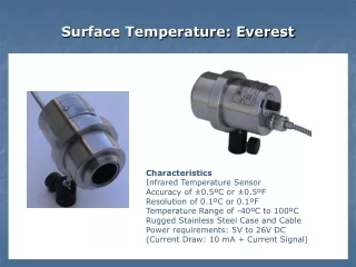
SkinDeEP Skin Depth Experimental Profiler Microstructure probes
Near surface temperature gradients – reality Profile measured at 12:51 local time on 4 October 1999. Off Baja California, R/V Melville MOCE-5 cruise. Blue line = SkinDeEP* profile Blue circle = M-AERI skin temp. Red cross = Float bulk SST at ~0.05m Green star = Ship thermosalinograph at ~3m From Ward, B. and P. J. Minnett, 2001. An autonomous profiler for near surface temperature measurements. Gas Transfer at Water Surfaces. M. A. Donelan, W.M. Drennan, E.S. Saltzmann and R. Wanninkhof (Eds.) American Geophysical Union Monograph 127. 167 - 172.
Time evolution of near-surface thermal gradients SkinDeEP profiles on 12 October 1999.Off Baja California, R/V Melville. From Ward, B. and P. J. Minnett, 2001. An autonomous profiler for near surface temperature measurements. Gas Transfer at Water Surfaces. M. A. Donelan, W.M. Drennan, E.S. Saltzmann and R. Wanninkhof (Eds.) American Geophysical Union Monograph 127. 167 - 172.
Wind speed dependence of the skin effect Note collapse of envelope at moderate to high wind speeds.
Wind speed dependence of diurnal & skin effects Note: effects of diurnal thermocline effects at low winds
Wind speed dependence of diurnal & skin effects Terra and Aqua overpass times.
Measurements of skin temperature Because of the effects of diurnal thermoclines and the skin layer, primary validation of MODIS SST should be by reference to surface-level measurements of skin temperature. This can be measured by filter radiometers or spectroradiometers on ships, aircraft or fixed platforms. The instruments must be well calibrated to reach the level of <0.1K absolute uncertainties. There are few such instruments available. One of which is the M-AERI……
Temperatures are traced to NIST • On-board black-body cavities have thermometers calibrated to NIST-traceable thermometers (SSEC) • Periodic calibration using a 3rd black body in M-AERI zenith view. • Periodic calibration of M-AERI system with a NIST-designed Water-Bath Black-Body target at RSMAS, using NIST-traceable reference thermometers. • RSMAS Water-Bath Black-Body target characterized with NIST EOS TXR NIST EOS TXR TXR characterizing the RSMAS WBBB
Time-series of M-AERI measurements on Explorer of the Seas The Explorer of the Seas is a Royal Caribbean Cruise Liner, operating a weekly schedule out of Miami. It is outfitted as an oceanographic and atmospheric research vessel, very suitable for satellite validation. For more details see http://www.rsmas.miami.edu/rccl/.
M-AERI data from Explorer of the Seas As at last Team Meeting…..
MODIS-M-AERI MatchupsBlue = Mediterranean – April 2000; Red =Pacific – March, April 2001;Pink = Pacific – March, April 2001;Green = Atlantic - Explorer of the Seas. All data M = 0.20K std= 0.26K N = 242 Explorer of the Seas M = 0.15K std= 0.21K N = 50
Cruise Name N Mean K St. Dev. K CSP 1996 23 0.16 0.20 24N 1998 16 0.03 0.18 GASEX 1998 168 -0.01 0.25 FPO 1998 47 0.27 0.40 NOW 1998 (Arctic) 176 0.24 0.44 Total, all data 430 0.13 0.37 Total, excluding NOW data 254 0.06 0.29 AVHRR-MAERI SST validation experience M-AERI validation of Pathfinder SSTs Using skin temperatures reduces the uncertainties by about a factor of two. See Kearns et al, 2000, Bull. Am. Met. Soc., 81, 1525-1536 254 0.06 0.29
Buoy Matchups SST Quality Flag = 0
Wind speed criterion for SST validation For winds > ~6ms-1, relationship between skin and bulk SSTs becomes quite well behaved, at the level of ~0.1K. In these conditions bulk SST may be used to validate satellite-derived SSTs. See Donlon, C. J., P. J. Minnett, C. Gentemann, T. J Nightingale, I. J. Barton, B. Ward and J. Murray, 2002. Towards improved validation of satellite sea surface skin temperature measurements for climate research. J. Climate. In the press.
Distribution of wind speed <6ms-1 Buoy data can be used, with caution, in blue areas From Donlon, C. J., P. J. Minnett, C. Gentemann, T. J Nightingale, I. J. Barton, B. Ward and J. Murray, 2001. Towards improved validation of satellite sea surface skin temperature measurements for climate research. J. Climate. In the press.
Are MODIS SSTs Validated? • VALIDATED PRODUCTS: science quality with well defined uncertainties; improvements may still be are ongoing. • These are high quality products suitable for longer term or systematic scientific studies and publication. There may will be later improved versions. • Within the limits of current analyses, (temporal and regional) ….. YES.
Are MODIS SSTs Validated? BUT…… • Sample size is still small • Some regions under-represented • Time-series not yet established • Continued validation into the future to determine effects of instrumental re-configurations
Future Plans • Establish reasons for regional and seasonal trends, and correct for these effects • Prepare for 2002 validation cruises (Terra and Aqua) • Prepare Aqua SST retrieval algorithm • Explore SST4 (4 μm) retrievals • Improve SST retrieval accuracies
Trans-oceanic sections USCG Ice-breakers across the Pacific, twice each year Container vessels, e.g. SAFMARINE - USA to SA along WOCE AX8 in Atlantic, several times each year Research cruises, e.g. NOAA S Ronald H. Brown
Conclusions • M-AERI provides a critical validation tool for MODIS SST • Buoys provide a valuable secondary validation, numbers allow sampling a wider selection of environmental variability • Initial, preliminary SST validation shows Terra MODIS comparable to best AVHRR • Need to establish lack of seasonal and regional biases • Need to validate experimental SST4 fields • Need to prepare for Aqua MODIS at launch SST algorithm.