Download

1 / 21
210 likes | 331 Vues
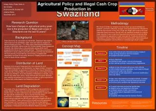
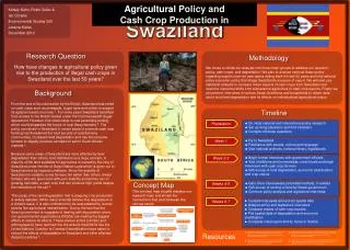
The Swaziland area survey. Choice Ginindza. Overview. Annual crop-cutting survey Concentrate on the measurement of areas under each crop Forms for collection What happens to the data after they have been collected. Each enumerator has a copy of this guide. Holding layout sketch plan.

E N D
The Swaziland area survey Choice Ginindza
Overview • Annual crop-cutting survey • Concentrate on the measurement of areas • under each crop • Forms for collection • What happens to the data • after they have been collected
Holding layout sketch plan Field 2 60% maize, 40% pumpkins Field 3 beans Field 4 maize Field 1 Maize
Field area measurements 1 2 2 0 1 0 5 2 0 1 113 100 112 60 139 40 125 50 27.5 0.85 0.25
Area in each field 01 Maize 100% 113 0.85 02 M 60% Pk 40% 112 139 03 Beans 100% 131 0.53 04 Maize 100% 113 0.98
Total crop area 0.151.83 0.610.53
What happens next? • 75 staff collect these area data • between November and January each year • The completed forms are sent to me in HQ • there are about 2000 forms each year • it is one form per household, unless a household has more than 12 fields • The forms are checked for consistency • before being sent for data entry • They are then sent for data entry • By the end of January
Then – the data are entered • Special software is used for the data entry • It is called CSPRO • and is designed specially for data entry • A headquarters' staff member • has programmed CSPRO • to make the data entry screen • the same as the data entry form • There are 7 staff • in the Government data entry team • and I add 2 of my staff just for this work • It takes about 2 weeks
Checking the data once entered • The resulting computer files • are returned to me • I first look at them in an editor • it is called OX-edit and is just like Notepad • that is on every computer • I use the editor to look for “shifts” • in the data from CSPRO • one character missing can make the transfer • to Excel or a statistics package very odd • That checking just takes an hour perhaps
The data now • Then I open the data in SPSS • That is a commonly used statistics package • They look the same in Excel – • as shown on the next slide • There are now 3945 records, • each one is a crop within a household. • Plus the household information
Checking in SPSS • I check the data in SPSS • That typically takes one day • I also have the paper records available • And check odd values against them • I correct in SPSS (and Ox-Edit) • Sometimes records are returned • to the data entry people • and there is a further round • Typically we find problems with 10 to 30 records
Analysis • Now I analyse the data using SPSS • That takes perhaps 1 day • The most important is maize, • so that is done first. • I get results from each Enumeration area • And then total them for each district • I compare with the previous year • as another check • I then export the summaries from SPSS to Excel
Results • Here is the sort of table I get.
Reporting • This information is then sent • to our Meteorological Service • They have to be there by the end of February • The met service estimates yields • And these estimates are multiplied • by these areas • To give the estimated production
Publishing • The estimates are then in a monthly • agroclimatic bulletin • Which is part of our NEW system • NEW = National Early Warning • to provide the food-balance sheet • for the current year • Later we produce our own report • once we have the yields as well