Download
1 / 25
250 likes | 405 Vues
An Introduction to the Northeast River Forecast Center. OUTLINE. General information about NERFC NERFC Activities NERFC Products Uniqueness of Lake Chaplain and tributaries of St Lawrence Forecasts. Mission of NOAA’s NWS Hydrologic Services Program.

E N D
OUTLINE • General information about NERFC • NERFC Activities • NERFC Products • Uniqueness of Lake Chaplain and tributaries of St Lawrence Forecasts
Mission of NOAA’s NWSHydrologic Services Program • Provide River and Flood Forecasts and Warnings for the Protection of Life and Property • Provide Hydrologic Information for the Nation’s Economic and Environmental Well-Being (Including Forecast Information for Water Resources Management)
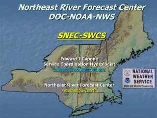
NERFC Area of Responsibility Major river basins include Genesee, Hudson, Connecticut, Merrimack & Kennebec
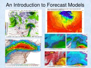
Advanced Hydrologic Prediction Services (AHPS) • Objective • Provide improved flood/river forecasting capabilities for the Nation • What will AHPS provide? • Extends current 1, 2, 3 day lead-times out to weeks and months • Provides river forecasts with uncertainty information for risk-based decisions • Provides visual flood-forecast products
NERFC AHPS FOCUS • Soil moisture modeling • Convert from event based API to continuous SAC SMA • Increase number of forecast points • Eventually will double the number of locations • Hydraulic routing • Lake Champlain • Lower Hudson and Connecticut Rivers
NERFC Activities • Operations • Hydrometeorological input • River forecasting • Product dissemination/coordination • Development • Model calibration • Procedures/Processes • System/Database
FORECAST POINTS • 178 River forecast points – most daily with issuance of 54 hours of 6 hour time series forecasts • This is an increase of 48 during the past 2 years • Most of increase has been in New York state and in Maine • An additional 27 new forecast points are planned
Data Sources • Volunteer Observers • Cooperative Federal and State Agencies • Synoptic Surface Observation Network (ASOS) • GOES satellite data collection platforms • Telephone telemetry • Radar Precipitation Estimates
Hydrometeorological Inputs • Quantitative Precipitation Forecasting (QPF) • Data quality control • Temperature forecasts
National Weather Service River Forecast System (NWSRFS) • Hydrologic and hydraulic modeling • Modular • Nationally supported • Requires local configuration and calibration
NWSRFS • Collection of models and processes • Snow accumulation/ablation • Compute runoff • Channel and reservoir routing • Components • Calibration • Operational forecasting • Ensemble streamflow prediction (ESP)
Calibration • Inventory and analysis of historical data • Time series based on historical data • Model selection • Calibration of model parameters
Operational Forecast System • Preprocesses observed and future data • Updates model state parameters • Provides short-term river and flood forecasts
Ensemble Streamflow Prediction • Uses historical precipitation, temperature, and evaporation data • Uses current model states from the operational forecast system • Produces medium to long range probabilistic forecasts
River Conditions Current and Forecast River Conditions
River Forecast Product • :W BR OSWEGATCHIE R AT HARRISVILLE NY ---PROVISIONAL- • :LATEST ESTIMATED DISCHARGE 1.1 KCFS AT 0700 EST ON 0220 .ER HVLN6 20060220 E DC200602201031/DH13/QTIFF/DIH6 • :FCST 7AM 1PM 7PM 1AM .E1 :0220: / 1.1/ 1.1/ 1.0 .E2 :0221:/ 1.0/ 0.9/ 0.9/ 0.9 .E3 :0222:/ 0.9/ 0.8 • :Local MAP - 4 6 hr pds - ending at 07AM EST on 0220. : 0.01/0.00/0.00/0.07/ • :Local QPF - 4 6 hr pds - ending at 07AM EST on 0221. : 0.08/0.08/0.00/0.00/ • : FORECAST FLOWS ARE PROVISIONAL ESTIMATES ONLY
GIS Maps • Precipitation • Temperature • Snowfall • Snow Depth • Snow Water Equivalent
Ensemble Streamflow Prediction • Based on 40 years of historical precipitation and temperature • Based on current snowpack and soil moisture conditions
Lake Champlain and tributaries of St Lawrence RiverForecasts • Lake Champlain • wind can have a significant impact • Tributaries of the St Lawrence • Flooding does not appear to be the primary interest • Interest is primarily on water volume • Real time data unavailable at some locations
QUESTIONS http://www.erh.noaa.gov/nerfc/