Flood Routing By Reservoir
460 likes | 1.26k Vues
Flood Routing By Reservoir. Presented By:. Prafulla Pokhara 2008 UCE 157 Poornima Vashishtha 2008 UCE 422 Om Prakash 2008 UCE 420 Pankaj Khatri 2008 UCE 421. SAFETY INSPECTION OF DAMS.

Flood Routing By Reservoir
E N D
Presentation Transcript
Flood Routing By Reservoir Presented By: PrafullaPokhara 2008 UCE 157 PoornimaVashishtha 2008 UCE 422 Om Prakash 2008 UCE 420 PankajKhatri 2008 UCE 421
SAFETY INSPECTION OF DAMS The dams are national property – constructed for the development of the national economy and in which large investments and other resources have been deployed. The safety of the dam is a very important aspect for safeguarding the national investment and the benefits derived by the nation from the project. In addition, an unsafe dam constitutes a hazard to human life and property in the downstream reaches.
CLASSIFICATION OF DAMS • Dams should be classified in accordance with size and hazard potential in order to formulate a basis for selecting dams. • The height of the dam is established with respect to the maximum storage potential measured from the natural bed of the stream or watercourse at the downstream toe of the barrier. • Size classification may be determined by either storage or height, whichever gives the large size category.
SIZE CLASSIFICATION CATEGORY STORAGE HEIGHT (hectare meters) (meters) Minor >6 and <125 >8 and <12 Medium >125 and <6250 >12 and <30 Major >6250 >30
SELECTION OF DAMS TO BE INVESTIGATED • The selection of dams to be investigated should be based upon an assessment of existing developments in flood hazard area. Those dams possessing a hazard potential classified high or significant. • Inspection priorities within each category may be developed from a consideration of factors such as size classification and age of the dam,the population size in the downstream flood area, and potential developments anticipated in flood hazard areas.
INVESTIGATION • Purpose:The primary purpose of the Phase I investigation programme is to identify expeditiously those dams which may pose hazards to human life or property. • Scope:The investigation will develop an assessment of the general condition with respect to safety of the project based upon available data and a visual inspection, determines any need for emergency measures and conclude if additional studies, investigation and analyses are necessary and warranted. • Based upon the findings of the review of engineering data and the visual inspection, an evaluation will be made of the general condition of the dam, including where possible the assessment of the hydraulic and hydrologic capabilities and the structural stability
Engineering Data: To aid in evaluating the adequacy of hydraulic and hydrologic capabilities and stability of the dam. • Field Inspections:Particular attention should be given to detecting evidence of leakage, erosion, seepage, excessive wetness or slushiness in the areas downstream of dam, presence of sand boils, change in water table conditions downstream, slope instability, undue settlement, displacement, tilting, cracking, deterioration and improper functioning of drains and relief wells.
EVALUATION OF STRUCTURAL STABILITY • Design and construction data • Operating records • Post construction changes • Seismic stability
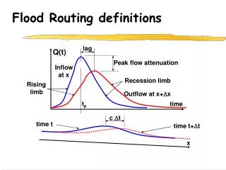
Various flood routing Strategies: Inter-Basin water transfer assessment (Ganga & Brahmaputra Basins) (ii) Flood Management by Reservoir in Pakistan (Tarbela & Mangla Reservoir) (iii)Extended Muskingum method for flood routing (Hirakud Reservoir)
1.Use of Geoinformatics for Inter-Basin water transfer assessment An Interlinking of Ganga and Brahmaputra River basin
Why we NEED it ? • India is a large sub-continent and, as a result, the challenges it faces are also on a large scale. • Uneven distribution of rain. • Drought in some parts of the country and floods in others.
The Indian river system:- Divided into two parts • Himalayan component:- the sources of which are the glaciers of the Himalayas and the monsoon rains. • Peninsular component:-consisting of water mainly from the monsoon rains. • There is surplus water in the Himalayan component and partial deficit in the peninsular component. • Especially during the dry season,resulting in inundation of agricultural land in areas with high precipitation and water scarcity and crop failure in areas with low precipitation.
Methodology • Based on the problems , aims, the data available, and technological know-how and its implementation. • Various methods can be used to identify possible locations for dams and reservoirs , and to determine the best route of canals. • The choice of method depends on the drainage characteristics and the terrain, as well as the technology appropriate for a particular environment.
How it is done? Procedure divided into 3 stages: Stage-1 • Deals with the terrain analysis (TA) required for reservoir location . • Thematic maps were generated from remote sensing data and a multi criteria analysis was undertaken using the thematic information to identify possible dam and reservoir sites.
Cont… Stage-2 • Deals with the estimation of reservoir storage capacity. • In which data were used as the input for an iterative numerical propagation method . • To determine the spatial extent of the reservoir and factors related to reservoir capacity.
Cont… Stage-3 • Concerned with identifying the best route for canals to transport the water from the reservoirs. • With the ultimate aim of joining the new canal to the existing canal system between the Teesta & Mahananda basins.
Limitations of the Methodology • The terrain analysis and multi criteria analysis included only some of the factors affecting site selection such as slope, drainage, geomorphology, geology , structure and land use regarding physical suitability and village location and transport networks regarding Socioeconomic suitability. • In reality, other factors such as the kind of drainage, drainage discharge, soil type and soil character would be required in the multi criteria assessment. • The data used as the input for elevation had a resolution of 90 m and were taken from a global data set useful for preliminary assessments of possible reservoir locations. • But when considering specific potential reservoir locations, high-resolution elevation data are essential as the data may underestimate slope steepness
Cont… • Neither the slope nor the condition of the terrain was considered in detail when determining the most suitable route of the link canal. • The assessment of the utilization of the water made available was based on certain assumptions regarding water transfer and reservoir capacity. • The actual availability in the study area was not determined. • The transfer volume was also assumed and only irrigation and human consumption were considered.But In reality , the water will also be used for other purposes.
2.Flood Management by Reservoir in Pakistan Introduction: • Tarbela Reservoir across river Indus and Mangla Reservoir across river Jhelum are two large reservoirs. Tarbelareservoir is about 850 km upstream of MithanKot. Four major tributary rivers join river Indus as a combined river below Panjnad Barrage. • A flood wave from downstream Tarbela is likely to take 9 days to reach MithanKot. Mangla reservoir is about 315 km upstream of the confluence of river Jhelum with river Chenab above Trimmu within 3.5 days. • Vulnerable population and structures exist a few kilometres downstream Mangla which may be hit by a flood in a short time. Therefore, flood management through Mangla Reservoir is a very sensitive issue in view of short lead time and enormous possible damage.
In case of severe floods like 1992 flood there is a possibility of reducing the Mangla Reservoir outflow from 8500 to 11500 cumecsby pre-releasing the stored volume or delaying the release by storing the inflow hydrograph. • However such decisions can’t be made without considering the flood hydrograph at Marala Barrage ,flood waves from downstream ManglaReservoir.NearTrimmu Barrage from Mangla Reservoir must include combined model of Jhelum and Chenab rivers.
Meteorological Aspects • Floods in Mangla catchment of river Jhelum and catchment of river Chenab occur due to monsoon depressions emerging from Bay of Bengal which travel to Rajasthan in India before moving to these catchments. • For Mangla catchment it is possible to make one day rainfall forecast when the weather system starts moving from Rajasthan or an alert can be given 2 to 3 days earlier.
Hydraulic Aspects • The flood waves in river Jhelum and river Chenab join at about 5 km upstream Trimmu Barrage. In such a case the resulting flood peak may exceed the capacity of Trimmu Barrage which is 18300 cumecs endanger life and property in the flooded areas. • The flood hydrograph downstream Mangla Reservoir along with the flood hydrograph at Marala Barrage should be routed through the combined hydrodynamic models of river Chenab and river Jhelum to pre-assess the flood situation at Trimmu.
Procedure used to ensure proper reservoir operation During the real time operation the following procedure should be used to ensure proper reservoir operation at Mangla Reservoir to avoid synchronization of flood at Trimmu Barrage. 1. Meteorological tracking of weather system as it originates from Bay of Bengal. 2. Quantitative rainfall forecast/measurement on Mangla Reservoir catchment. 3. The forecast/measured rainfall will be used to compute the inflow hydrograph at Mangla Reservoir using the rainfall-runoff models.
4. The computed inflow hydrograph at Mangla Reservoir should be routed using the reservoir routing model. If the outflow from the reservoir exceeds the 14000 cumecs then different operational scenarios of Mangla Reservoir may be formulated and reservoir routing can be carried out. 5. The outflow hydrograph at Mangla Reservoir (boundary condition of river Jhelum branch of hydrodynamic model) should be routed along with the real time flood hydrograph at Marala Barrage (boundary condition of river Chenab branch of hydrodynamic model). 6.Verify the flood hydrographs at intermediate stations to ascertain the peak discharges will not endanger their safety .Compare the peak discharge at Trimmu Barrage with the capacity of Trimmu Barrage. 7.If flood hydrograph at Trimmu Barrage exceeds its capacity go back to step 4 to formulate a new scenario at downstream Mangla Reservoir by reservoir operation and repeat steps 5 and 6. Repeat until acceptable situation at Trimmu is achieved.
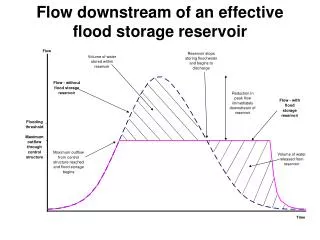
Conclusions • Large storage volume is available in Mangla Reservoir can be utilized efficiently only if a proper decision support system is available. outflow scenarios should be formulated using the reservoir routing modules in which the maximum Mangla release is limited to avoid damage. • The time of concentration of flood peaks at Mangla Reservoir and Marala Barrage are similar and travel in almost same time to point of confluence i.e. damage at Trimmu and downstream in river Chenab. Therefore it is essential that any Mangla release scenario should be checked for possible discharge. • With outflow hydrograph from Marala Barrage by channel routing use combined hydrodynamic flow model of river Jhelum and river Chenab.
3.Extended Muskingum method for flood routing: • The factors causing floods at flood control station are : • (i)The release of water for power and spill from reservoir, • (ii)Measured inflow to the river from tributaries between the reservoir and the flood control station and • (iii) Unmeasured lateral flow from the intermediate catchment • Extended Muskingum method comprises with multiple inflows & single outflow • So this method has the ability to account for the lateral inflows also.
Hirakud Reservoir: • Hirakud reservoir, is situated in Mahanadi basin, Orissa, • India. Area of the basin is 1,41,600 sqkm. • Mahanadi river originates in Raipur district of Madhya Pradesh After a run of 450 km from its starting point, the Hirakud dam was built across the river. • The multipurpose Hirakud reservoir is utilized mainly for three purposes, flood control, irrigation, and hydropower production in that order of priorities. • Hirakud dam is expected to control flood in coastal delta area by limiting the flow at Narajflow measuring station to be within 25,500 cumecs.
The 320 km long reach of river between Hirakud reservoir • and Naraj is treated in this study for flood routing. Flood data from 1992 to 1995 are considered for the purpose. • The outflow from the reservoir is the combination of the • spill from the reservoir and the release for power. This outflow is measured at the dam. • Two tributaries, Ong and Tel, join Mahanadi river on the downstream of Hirakud reservoir and their flow is measured at Salebhat& Kantamalstation. • Because the confluence points of these two tributaries with Mahanadi river are quite close, compared to the length of river, so the flow at Sukma ,Salebhat, Kantamalstations are combined and termed as d/s catchment contribution.
The difference between inflow into the reach and outflow from the reach, i.e., flow at Naraj, constitutes the lateral flow into the routing reach. • It is observed that the unmeasured lateral flow varies widely from one flood to other. This is not having any specific ratio to the volume of inflow or volume of outflow. • The floods are classified into two categories. • Both outflow from reservoir and d/s catchment contribution influence the pattern of flow at Naraj and • Only outflow from reservoir has the influence on the flow. • It is proposed to evaluate the performance of gate operation once in 24 h, 18 h, 12 h, and 6 h to find out the effect of these variations on the predicted flow at Naraj .
Conclusion of this method: • It is observed that mean relative error in computation of flow decreases systematically with decrease in routing interval, both for calibration and testing phase. • In addition, it is also observed that the flows predicted by Muskingum method are less than the observed flows . • So extended Muskingum method can be explored for similar reservoir configuration such as Hirakud reservoir system.
Research on New techniques of river flow measurement on flood condition: 1.Hand held Radar The difference in the frequency between the transmitted & reflected signal is proportional to the speed of water surface.
2.Acoustic Doppler Current Profiler(ADCP): • ADCP transmits sound bursts into water & measure the reflected signal from particles suspended in the water column. • The frequency shift between the transmitted & reflected sound (Doppler Shift) is used to compute the particle velocity.
References: 1.K.H.V. DurgaRao ,V. Bhanumurthy , P.S. Roy ,2009 .Application of Satellite - based Rainfall Products and SRTM DEM in Hydrological Modelling of Brahmaputra Basin .Indian soc. remote sens. (december 2009) 37:587–600. 2.Niladri Gupta, PetterPilesjo, and Ben Maathuis, 2009.Use of Geoinformatics for Inter -Basin Water Transfer Assessment .ISSN 0097-8078, Water Resources, 2010, Vol. 37, No. 5, pp. 623–637. 3. Dr.shahbaz khan. Decision support system for reservoir operation to manage severe floods in Pakistan, National Engineering service of Pakistan pvt. Ltd.,576. 4. D. Nagesh Kumar , FalguniBaliarsingh , K. SrinivasaRaju ,2011.Extended Muskingum method for flood routing. Hydro-environment Research 5(2011) 127-135. 5. Government of India manual onGuidelines for Safety Inspection of Dams.