Download
1 / 5
50 likes | 169 Vues
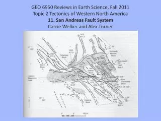
GEO 6950 Reviews in Earth Science, Fall 2011 Topic 2 Tectonics of Western North America 11. San Andreas Fault System Carrie Welker and Alex Turner. Geography of the SAFS. The entire system is a zone approximately 3000 km long.

E N D
GEO 6950 Reviews in Earth Science, Fall 2011Topic 2 Tectonics of Western North America11. San Andreas Fault SystemCarrie Welker and Alex Turner
Geography of the SAFS The entire system is a zone approximately 3000 km long. It is bounded in the north by the Mendocino trench – transform – transform triple junction off north western California. It is bounded in the south by the Rivera ridge – trench – transform triple junction near the mouth of the Gulf of California. A splay off the SAFS called the Eastern California shear zone is connected with the main fault system south of the big bend. It trends north along the eastern front of the Sierra Nevada, where it is known as the Walker Lane belt.
SAFS Physical and geological characteristics Right-lateral transform plate boundary between Pacific and North American tectonic plates. Pacific plate moving northwestward at 28-34 mm yr-1 ~550 km of total displacement since formation 15-20 Ma Both seismic and aseismic slip occur on locked and creeping segments of SAF San Andreas Fault Observatory at Depth (SAFOD) at Parkfield, CA North American Plate Pacific Plate Fault Core contains the weak smectite clay mineral saponiteaseismic slip?
SAFS Important Chronology Formation - 15-20 Ma the Pacific-North American plate boundary transitions from a subduction to a transform boundary (Farallonsubduction to right-lateral strike-slip on SAF) Historical Earthquakes