Download
1 / 24
240 likes | 474 Vues
Natural Disaster Preparedness in the Pacific Northwest (PNW): Plate Tectonics and Their Hazards. Audience: Washington State Residents Presented By: Emily Brown Walden University PUBH 6165-2 Environmental Health Professor Rebecca Heick Winter, 2010.

E N D
Natural Disaster Preparedness in the Pacific Northwest (PNW):Plate Tectonics and Their Hazards Audience: Washington State Residents Presented By: Emily Brown Walden University PUBH 6165-2 Environmental Health Professor Rebecca Heick Winter, 2010 .
Figure 1: Columbia River Plateau. (USGS, 2009) Pacific Northwest • Ranges Northern California to Southeast Alaska • Geologically diverse and active • Part of “Ring of Fire” Alt, DD & Hyndman, DW. (1994) Roadside Geology of Washington. Mountain Press Publishing Company. Missoula, Montana. United State Geological Survey (USGS). (2009) Columbia River Basalt. Retrieved January 20, 2010 from http://vulcan.wr.usgs.gov/Volcanoes/ColumbiaPlateau/description_columbia_plateau.html USGS. (2003) Ring of Fire. Retrieved January 20, 2010 from http://vulcan.wr.usgs.gov/Glossary/PlateTectonics/description_plate_tectonics.html
Earth Figure 2: Mantle Convection (West, 2009) West, K. (2009) Layers of the Earth. Franklin Institute. InfoBase Publishing New York NY.
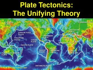
Plate Tectonics Figure 3: Plate Tectonics: In the middle of the map lies the Pacific Ocean Plate its boundaries represent the most geological active area in the world know as the “Ring of Fire”. USGS. (2009) Dynamic Earth. Retrieved January 21, 2010 from http://pubs.usgs.gov/gip/dynamic/dynamic.pdf
Plate Tectonics (cont.) Figure 4: Three types of plate interactions. (USGS, 2009) USGS. (2009) Dynamic Earth. Retrieved January 21, 2010 from http://pubs.usgs.gov/gip/dynamic/dynamic.pdf
PNW Plate tectonics Consists of all three types of plate interaction. These interactions puts the PNW at risk for volcanic eruptions, earthquakes, and Tsunamis. Figure 5: Plate interactions in the PNW and seismic activity from 1996 to 2002. (USGS, 2009) Lovgren, S. (2003) Did North America Quake Cause the 1700 Japan Tsunami? National Geographic. Retrieved January 22, 2010 from http://news.nationalgeographic.com/news/2003/12/1208_031208_tsunami.html USGS. (2009) Dynamic Earth. Retrieved January 21, 2010 from http://pubs.usgs.gov/gip/dynamic/dynamic.pdf
Volcanoes Figure 6: Events of Mt St Helens Eruption on May 18, 1980. (USGS, 2009) Mt St Helens eruption has lead to advances in prediction of volcanism, which has saved lives. Montgomery, CW. (1997) Environmental Geology. McGraw Hill. 5th Ed. USGS. (2009) Dynamic Earth. Retrieved January 21, 2010 from http://pubs.usgs.gov/gip/dynamic/dynamic.pdf
Mt Rainier Fig 7: Potential hazards associated with Mt Rainier. The orange areas are effected by major lahars events in the past. (USGS, 2009) United States Census Bureau. (2009) "Annual Estimates of the Population of Metropolitan and Micropolitan Statistical Areas: April 1, 2000 to July 1, 2008 (CBSA-EST2008-01)" (CSV). Population Division. Retrieved January 22, 2010 from http://www.census.gov/popest/metro/tables/2008/CBSA-EST2008-01.csv. USGS. (2009) Dynamic Earth. Retrieved January 21, 2010 from http://pubs.usgs.gov/gip/dynamic/dynamic.pdf
Earthquakes Fig. 8 Type of motion patterns generated by earthquakes Types of waves • Body waves • P-waves • S-waves • Surface waves • Rayleigh waves • Love waves USGS. (2005) Seismic Waves. Retrieved January 24, 2010 from http://earthquake.usgs.gov/learn/topics/?topicID=63
Tsunamis Figure 9. 1998 Tsunami model of Papua New Guinea that resulted in 2200 deaths. USGS. (2008) Model of Papua New Guinea Tsunami. Retrieved January 24, 2010 from http://walrus.wr.usgs.gov/tsunami/PNGhome.html
Overview of Hazards in the PNW PNW geological hazards will happen, so the focus is on how to lessen their impact, not prevent them. Though warning systems and evacuation plans are put in place, only volcanic prediction models have proven reliable. USGS. (2009) Dynamic Earth. Retrieved January 21, 2010 from http://pubs.usgs.gov/gip/dynamic/dynamic.pdf
Emergency Kits America Red Cross (2009) recommends a basic kit should include the following: • A 3 day supply of water and food. • Flashlight • Battery-powered or hand cranked radio and/or cell phone with charger • First Aid Kit • Whistle • Multipurpose tool • Dust Mask, Duct Tape, Garbage Bags and Toilet Paper American Red Cross. (2007) Build a kit. Retrieved January 23, 2010 from http://www.redcross.org/preparedness/educatorsmodule/EDU_Be_Disaster_Safe/6-8%20BDS%20LP%208%20build%20a%20kit.pdf Katz, L. (2010) iPhone App Helps Man Survive Haiti Quake, CNet News. Retrieved February 09, 2010 from http://news.cnet.com/8301-17938_105-10438121-1.html
Additional Emergency Kits Supplies • Matches • Fire extinguisher. • Needles and thread. • Paper plates, plastic cups and utensils. • Chlorine bleach and other disinfectant cleaners. • Writing supplies and contact numbers. • Copies of important documents. Cash or traveler's checks. • Blankets, bedding, sleeping bags. • Comfortable clothes and shoes. • Supplies for babies, children, elderly, and pets. American Red Cross. (2007) Build a kit. Retrieved January 23, 2010 from http://www.redcross.org/preparedness/educatorsmodule/EDU_Be_Disaster_Safe/6-8%20BDS%20LP%208%20build%20a%20kit.pdf
Preparing for a disaster. • Evaluate the surrounding environment. • Know evacuation routes and meet up locations. • Have emergency kits readily available. • If ask to evacuate…evacuate. American Red Cross. (2009) Earthquake Safety Checklist. http://www.redcross.org/www-files/Documents/pdf/Preparedness/checklists/Earthquake.pdf USGS. (2009) Dynamic Earth. Retrieved January 21, 2010 from http://pubs.usgs.gov/gip/dynamic/dynamic.pdf
What to do in a Earthquake? If you are inside when the shaking starts … Drop, Cover and Hold! Figure 10. Drop, Cover and Hold. American Red Cross. (2009) Earthquake Safety Checklist. http://www.redcross.org/www-files/Documents/pdf/Preparedness/checklists/Earthquake.pdf University of Washington. () UW Emergency Management: Drop Cover and Hold Poster. Retrieved February 1, 2010 from http://www.washington.edu/emergency/prepare/drop_cover_hold
What to do in a Earthquake? If you are outside when shaking starts…Find a clear, open spot and drop to the ground. If you are driving, if safety permits pullover, and stay in your vehicle! Figure 11. Photographs of some damage caused by the 1994 Northridge earthquake. American Red Cross. (2009) Earthquake Safety Checklist. http://www.redcross.org/www-files/Documents/pdf/Preparedness/checklists/Earthquake.pdf FEMA (2009) What to Do in an Earthquake. Retrieved February 3, 2010 from http://www.fema.gov/hazard/earthquake/eq_during.shtm South California Earthquake Data Center. (1994) Northridge Earthquake. Retrieved February 3, 2010 from http://www.data.scec.org/chrono_index/northshow.html
What to do after an Earthquake After an earthquake, the disaster may continue. Expect and prepare for potential aftershocks, landslides or even a tsunami. American Red Cross. (2009) Earthquake Safety Checklist. http://www.redcross.org/www-files/Documents/pdf/Preparedness/checklists/Earthquake.pdf • Each time you feel an aftershock, respond and take appropriate actions. • If you are okay, help others, if not seek first aid. • Cover exposed skin, to avoid injury if available. • Listen to a portable, battery-operated or hand-crank radio for updated emergency information and further instructions. • Help people who require special assistance, such as infants, children and the elderly or disabled.
What to do after an Earthquake • Assess for damage. • Check for phone service, and make brief calls to report life-threatening emergencies. • Extinguish small fires if able. • Clean up potential spilled hazards immediately if you are able. • Note and stay clear of hazards such as fallen power lines, broken gas lines, or damaged areas. American Red Cross. (2009) Earthquake Safety Checklist. http://www.redcross.org/www-files/Documents/pdf/Preparedness/checklists/Earthquake.pdf
What to do after an Earthquake • Keep animals under your direct control. • Stay out of damaged buildings. • If you were away from home, return only when authorities say it is safe to do so. • Use extreme caution and examine walls, floors, doors, staircases and windows to check for damage. • Be careful when driving after an earthquake and anticipate traffic light outages” American Red Cross. (2009) Earthquake Safety Checklist. http://www.redcross.org/www-files/Documents/pdf/Preparedness/checklists/Earthquake.pdf
Conclusion Plate Tectonics occur worldwide in three distinct patterns. These collisions result in potential hazards ranging from earthquakes to tsunamis to volcanoes. It is difficult to know when, but we know they will happen! So it is best to be prepared!!!!
Additional Information • American Red Cross. (2009) Preparedness Fast Facts. http://www.redcross.org/portal/site/en/menuitem.86f46a12f382290517a8f210b80f78a0/?vgnextoid=92d51a53f1c37110VgnVCM1000003481a10aRCRD&vgnextfmt=default • Hill, R. (2004) Volcanoes of the Cascades. The Globe Pequot Press. • NOAA. (2010). Earthquakes. http://www.noaawatch.gov/themes/quake.php • NOAA (2010) Tsunami Website. http://www.tsunami.noaa.gov/ • Pierce County. Mt Rainer Evacuation Plan. http://www.co.pierce.wa.us/pc/Abtus/ourorg/dem/EMDiv/Mt%20Rainier%20VHRP.htm • Ready America (2009) Get a Kit. http://www.ready.gov/america/getakit/kit-print.html • USGS. (2010) Hazards. http://www.usgs.gov/hazards/
References Alt, DD & Hyndman, DW. (1994) Roadside Geology of Washington. Mountain Press Publishing Company. Missoula, Montana. American Red Cross. (2007) Build a kit. Retrieved January 23, 2010 from http://www.redcross.org/preparedness/educatorsmodule/EDU_Be_Disaster_Safe/6-8%20BDS%20LP%208%20build%20a%20kit.pdf American Red Cross. (2009) Earthquake Safety Checklist. http://www.redcross.org/www-files/Documents/pdf/Preparedness/checklists/Earthquake.pdf FEMA (2009) What to Do in an Earthquake. Retrieved February 3, 2010 from http://www.fema.gov/hazard/earthquake/eq_during.shtm Katz, L. (2010) iPhone App Helps Man Survive Haiti Quake, CNet News. Retrieved February 09, 2010 from http://news.cnet.com/8301-17938_105-10438121-1.html Lovgren, S. (2003) Did North America Quake Cause the 1700 Japan Tsunami? National Geographic. Retrieved January 22, 2010 from http://news.nationalgeographic.com/news/2003/12/1208_031208_tsunami.html Montgomery, CW. (1997) Environmental Geology. McGraw Hill. 5th Ed. South California Earthquake Data Center. (1994) Northridge Earthquake. Retrieved February 3, 2010 from http://www.data.scec.org/chrono_index/northshow.html
References United States Census Bureau. (2009) "Annual Estimates of the Population of Metropolitan and Micropolitan Statistical Areas: April 1, 2000 to July 1, 2008 (CBSA-EST2008-01)" (CSV). Population Division. Retrieved January 22, 2010 from http://www.census.gov/popest/metro/tables/2008/CBSA-EST2008-01.csv. United State Geological Survey (USGS). (2009) Columbia River Basalt. Retrieved January 20, 2010 from http://vulcan.wr.usgs.gov/Volcanoes/ColumbiaPlateau/description_columbia_plateau.html USGS. (2009) Dynamic Earth. Retrieved January 21, 2010 from http://pubs.usgs.gov/gip/dynamic/dynamic.pdf USGS. (2008) Model of Papua New Guinea Tsunami. Retrieved January 24, 2010 from http://walrus.wr.usgs.gov/tsunami/PNGhome.html USGS. (2003) Ring of Fire. Retrieved January 20, 2010 from http://vulcan.wr.usgs.gov/Glossary/PlateTectonics/description_plate_tectonics.html USGS. (2005) Seismic Waves. Retrieved January 24, 2010 from http://earthquake.usgs.gov/learn/topics/?topicID=63
References University of Washington. () UW Emergency Management: Drop Cover and Hold Poster. Retrieved February 1, 2010 from http://www.washington.edu/emergency/prepare/drop_cover_hold West, K. (2009) Layers of the Earth. Franklin Institute. InfoBase Publishing New York NY.