Download
1 / 17
170 likes | 322 Vues
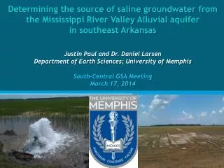
Determining the source of saline groundwater from the Mississippi River Valley Alluvial a quifer in southeast Arkansas Justin Paul and Dr. Daniel Larsen Department of Earth Sciences; University of Memphis South-Central GSA Meeting March 17, 2014. Study Area and Regional Geology .

E N D
Determining the source of saline groundwater from the Mississippi River Valley Alluvial aquiferin southeast ArkansasJustin Paul and Dr. Daniel LarsenDepartment of Earth Sciences; University of MemphisSouth-Central GSA Meeting March 17, 2014
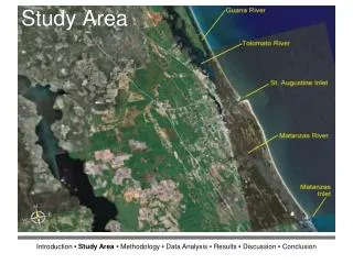
Study Area andRegional Geology Modified from Cox et al. (2013) Modified from Wikipedia
Alluvial Aquifer • Quaternary sands and gravels (Ackerman, 1996) • Capped by silt and clay confining unit (Ackerman, 1996) Modified from Ackerman (1996)
Occurrence of saline groundwater • Chloride condition could be due to evaporative processes in near surface (Kresse and Clark, 2008). • Cannot discount vertical migration of saline fluids along faults (Kresse and Clark, 2008). Modified from Kresse and Clark (2008)
Soils • Mostly clay-rich varieties derived from backswamp deposits (Saucier, 1994) • On the whole, elevated Cl concentrations in backswamps (Kresse and Clark, 2008) Modified from Kresse and Clark (2008)
Sand-blows • Cox et al. (2004&2007) • Tell us multiple things: • Paleoseismicity • Elevated pore pressures Local Faults Area I • Arkansas & Saline River Fault Zones • Area I has same orientation as regional structural grain • Area II is distinctly linear Liquefaction Fields Area II Modified from Cox et al. (2007)
Brines at Depth • Jurassic age formations • Evaporative and shallow marine deposits associated with opening of Gulf of Mexico (Harry and Londono, 2004) • Basinal brines with unusual chemistry (Hanorand McIntosh, 2007) Modified from AR Geological Survey
Geothermal Anomaly at Depth Modified from SMU Geothermal Laboratory Google Earth Application
Hypotheses • Chloride condition due to… 1. Evapotranspiration processes whereby clay-rich soils restrict recharge and concentrate chloride in infiltrating surface water. 2. Injection of chloride-rich fluids from depth into the aquifer through faults during previous earthquakes and still migrating today. 3.Regional rivers recharging relatively chloride-rich water into the alluvial aquifer when river levels are higher than the water-table.
Methods Geochemical and statistical techniques to solve this hydrogeologic problem: • Principle Component Analysis • Spatial Statistical Analysis • Hydrologic Tracer Analysis
Chicot; Very Salty Principle Component Analysis Chicot; Salty Alluvial Aquifer Desha; Dilute • n= 177 • EV-1=91% of variance • Heavy negative weights on Ca, Mg, Na, Cl, SO4 • Dilute end-member • EV-2=4% of variance • Heavy positive weight on Cl • Heavy negative weights on Ca and SO4 Desha; Salty Chicot; Rel. Salty Sparta Aquifer • n= 57 • EV-1=84% of variance • Heavy negative weights on Na and Cl • EV-2=9% of variance • Heavy positive weight on Ca and Cl • Heavy negative weight on Na Both Desha; Dilute
Spatial Analysis • Seeking statistical relationship between location and density of sand-blows to Cl content in groundwater Modified from Kresse and Clark (2008) and Cox et al. (2007)
Hydrologic Tracer Analysis Interpretations
Cl content vs 14C age in alluvial groundwaters Chicot ; Very Salty ; Backswamp Desha ; Dilute ; Backswamp Desha ; Salty ; Backswamp
Conclusions • Using geochemistry and statistics to solve a hydrogeological problem • Methods will test vastly different hypotheses • Near-surface evaporative concentration of chloride in recharging groundwater 2. Injection of chloride-rich waters from depth through faults 3. Regional rivers recharging relatively chloride-rich water into the alluvial aquifer • Evidence suggests evap. evolved, pre-modern crustal waters mixing with fresher, younger meteoric waters
Special Thanks • Tim Kresse- data • Geological Society of America- funding • U. of Memphis Dept. of Earth Sciences- support • U. of Arkansas Stable Isotope Lab- support • U. of Miss. Geology & Geo. Engineering Dept.-support • South-Central GSA- travel considerations