Download
1 / 30
310 likes | 829 Vues
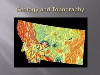
Geology and Topography. geology. The study of the earth and other planets What they are made of How they were formed erosion volcanic water. geology. Locating water Mineral resources Understanding the development Predicting models Earthquakes Volcanoes. geology.

E N D
geology • The study of the earth and other planets • What they are made of • How they were formed • erosion • volcanic • water
geology • Locating water • Mineral resources • Understanding the development • Predicting models • Earthquakes • Volcanoes
geology • Discovery of resources • Gravel • Stone • Oil • Coal • Water • Minerals
geology • Shape of the landscape • Where to build • Where not to build • Earth formation • 4.6 billion years ago • James Hutton - 1800 • uniformitarianism
Geological Time • Precambrian • prior to 543 million years ago • Paleozoic • 543 to 251 million years ago • Mesozoic • 251 to 65 million years ago • Cenozoic • 65 million years to present http://web.eps.utk.edu/courses/HistoricalGeo/geotime.html
Precambrian • The formation of the Sun and light • The formation of the Earth • The formation of the atmosphere through volcanic out-gassing • The formation of the oceans • The formation of life
Precambrian cont. • Earth’s history before the formation of the oldest rocks with fossils in them • Covers almost 90% of Earth’s history • Basement complex
Paleozoic • Two of the most important events in the history of animal life • Missing in most of Montana • Economic important http://www.ucmp.berkeley.edu/paleozoic/paleozoiclife.html
Mesozoic • Triassic, Jurassic and Cretaceous make up the Mesozoic • Dinosaurs • Out crops over 55 percent of the area of Montana
Cenozoic • Most recent of the three major subdivisions of animal history • Age of the Mammals • Two main sub-divisions • Tertiary (65-1.8 million years) • Quaternary (1.8-present) • Glaciations
Rock Types - Igneous • Composition • Made of • Texture • Size of crystals • Form • Underground • Above ground • Cooling magma • Volcanic • lava
Rock Types - sedimentary • Make up most of the Earth’s crust • Types of sedimentary rocks • Clastic • Basic/clast • Chemical • Salt/gypsum • Organic • Shells/bones/teeth http://eqdoc.home.netcom.com/salt2.html
Rock Types - metamorphic • Meta • Change • Morph • form • Change because • Heat • Pressure • Chemical fluids http://epod.usra.edu/blog/2006/04/armed-intrusions.html
Watershed • What is a Watershed? • Surface water • Groundwater • Watershed Divide • Channel • Meandering • Braded • Straight • Gradient www.thewatershed.org/.../ watersheddiagram.gif)
Channel Types • Straight • Meandering • Braided • Alluvial Fan http://itc.gsw.edu/faculty/bcarter/physgeol/river/types.htm
Topography • Mapping of surface features • Area features • Description of features • Strongly influenced by the stratigraphy and structure of the underlying rocks http://geology.com/store/mapcard.shtml
Aerial Photography • Record all visible features • Excellent source of spatial data • Used to Id large features
Cascade County geology • Western Interior Seaway • Seaway began in the mid-Cretaceous • All rivers in Montana flowed north • Glacial influence
Glacial Lake Great Falls • Glacial Lake Great Falls was a prehistoric proglacial lake • extended as far north as Cut Bank. • as far south as Holter Lake • Glacial Lake Great Falls reached a depth of 600 feet right here at East Middle school
Lost Lake • The rocks and 250-ft. cliffs tell of a fascinating past, including a time when an ancient sea covered the area, • an episode of volcanic activity • more recent period when ice age floods shaped the landscape
Independent study • Stream Reach • All parts • watersheds • Glaciers • Geology • Rocks & minerals of Montana