Download
1 / 15
150 likes | 282 Vues
Ecosystem Modeling Framework For Quantitative Seascape Ecology Supporting Ecosystem Assessment and Management. Howard Townsend NOAA/NMFS/OHC/Chesapeake Bay Robert Gamble NOAA/NMFS/NEFSC/ EcoAP. How and When to Use Models: Adaptive Management.

E N D
Ecosystem Modeling Framework For Quantitative Seascape Ecology Supporting Ecosystem Assessment and Management Howard Townsend NOAA/NMFS/OHC/Chesapeake Bay Robert Gamble NOAA/NMFS/NEFSC/ EcoAP Habitat Workshop - March 1 & 2, 2012
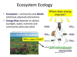
How and When to Use Models: Adaptive Management • Identify the problem (a management question or an ecological hypothesis) • Use existing data to develop a first cut model of the system • Collect relevant data • Refine models with data • Apply model to the problem • Assess utility of model to solve problem, and refine (the problem, the data, and/or the model) • Repeat steps 3-6 until the problem is sufficiently resolved
Example: How and When to Use Models • Chesapeake Blue Catfish • NE US Atlantis example
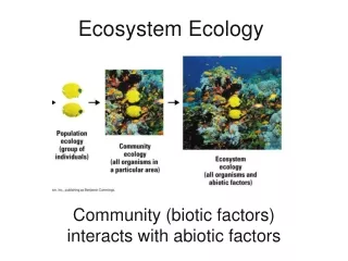
Chesapeake Bay – Blue Catfish • Applied fisheries ecosystem models (using EwE) to generate quantitative estimates of the impacts of BCF on other species. This is first attempt to assimilate our knowledge on BCFs in the ecosystem (step 2). • Ran management scenarios to understand how fisheries and water quality management can be used to regulate BCF (steps 5-6). • Used ecosystem model to guide research and monitoring directions (steps 3-4).
Identify a problem and model • Baseline Scenario • Hypothetically maintain status quo in current fishing regulations and effort • 20-yr projection of changes in Biomass of key species • Baseline Major Impacts • White Perch • Alosines • Blue Crabs • Striped Bass • Croaker
Apply Model and Assess Utility • Increasing exploitation rates had little affect on blue catfish populations. • An overwhelming control of the system through different levels of nutrient inputs. • Perhaps habitat has more of an influence than fishing?
Refine Model – Include habitat and seascape/water quality Longer Term… Finer spatial scale evaluation of BCF in the Chesapeake Bay system. Model would be completed using the Ecospace option within EwE. Ecospace model could provide… -Spatially specific predator and prey interactions. -Better understanding impacts of BCF impacts on anadromous species. -Opportunity to include current research for more precise parameterization of the CBFEM. -Recommendations on where tributary specific removal campaigns may be effectively applied.
Pelagic Epibenthic Sediment ATLANTIS NEUS – Model Structure 0 50 120+ 300+ Northeast United States – (22, 8)
ATLANTIS NEUS – Model Structure 45 Functional Groups 18 Fishing fleets (based on gear and target species)
ATLANTIS NEUS – Habitat Parameters • Benthic • Depth (determines number of layers) • Bottom type (scallop, other bivalves, reef, flat, soft, canyon) • Patchiness of bottom type • How resistant to damage from fishing the bottom is • Oceanographic • Temperature (time series, or modeled) • Salinity (time series, or modeled) • Current flows (average flows per unit time across box edges) • Biological • Nutrients (locations of high concentration, changes over time)
ATLANTIS NEUS – Habitat Usage In the Model • Habitat types: • Fisheries can be flagged to avoid any of the habitat types • Functional groups prefer specific habitat types (juveniles or adults) • Effects of degradation can be simulated • Effects of closures for habitat types can be simulated • Nutrients: • Location and magnitude affects primary productivity and food web effects in the model • Effects of lower or higher nutrient levels can be simulated • Temperature and Salinity: • Climate change effects can be simulated, with regards to distribution and abundance of functional groups
ATLANTIS NEUS – Habitat Time & Spatial Scales • Temporal Scales: • Any time step permitted, but generally done at half day to daily scales • Spatial Scales: • Generally 10’s – 1000’s km2 dependent on scale important to the functional groups and fisheries
ATLANTIS NEUS – Example Effects of closing eastern portion of Georges Bank
The answer is… * 42 What was the question? * D. Thought, personal communicatiom
Useful Ecosystem Modeling Frameworks • Existing software (code base) packages • Ecopath with Ecosim • Atlantis • Made from scratch • BSIERP • Others