Latitude Longitude
Latitude Longitude. History. Use of grid lines originated from about 300 B.C.E by Greek astronomers Hipparcus and Ptolemy Used spherical trigonometry observations using sun, moon, and stars to plot points on a spherical earth

Latitude Longitude
E N D
Presentation Transcript
History • Use of grid lines originated fromabout 300 B.C.E by Greek astronomers Hipparcus and Ptolemy • Used spherical trigonometry observations using sun, moon, and stars to plot points on a spherical earth • About 225 B.C.E, Eratosthenes measured circumference of the earth.
History • Knowing these dimensions, latitude was easily calculated. • Measured sun’s angle at noon relative to the equator. • Noon was determined simply from the highest point of the sun. • Longitude was much harder to calculate, however
History • East-west distance from one place to another on the earth could be plotted from position of sun and stars, but only if the time difference between the two places was known. • Inexact until invention of telescope and an accurate clock in the 16th century • 1760, John Harrison invented an exact marine chronometer.
Lines of longitude only Equator added Other lines of latitude added
Cross-section through line of longitude Cross-sections through lines of latitude
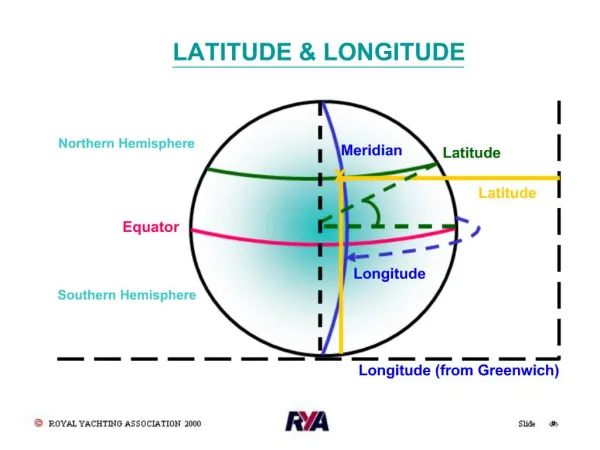
Latitude • “Lat is Flat” • Latitude lines run horizontally and are also known as parallels • Each degree of latitude is approximately 69 miles apart, but there is some variation due to the earth being an oblate ellipsoid.
Latitude • Equator is latitude line of 0 degrees. • Values indicate angular distance between Equator and points north or south of the surface of the Earth • Degrees latitude are numbered from 0 – 90 north and south (90N is North pole; 90S is South pole)
Longitude • Longitude lines run vertically and are also called meridians. • Converge at poles and are widest at equator • Zero degrees longitude is located at Greenwich, England. Established in 1884. “Prime meridian”.
Longitude • Degrees continue 180 degrees east and 180 degrees west where they meet and form the International Date Line
International Date Line America to Asia – gain a day Asia to America – lose a day
Precision • Degrees of latitude and longitude can be further subdivided into minutes and seconds. • 60 minutes per degree (‘) • 60 seconds per minute (“) Ex. 40°06'36.88"N 88°13'38.13"W
Precision • Values can be also be expressed as decimals: • Ex. 65.5375 • Degrees and decimal minutes: • Ex. 65⁰ 32.25’ • Degrees, minutes, decimal seconds: • Ex. 65⁰ 32’ 15.275” • Accurate to within inches.
Precision • A typical coordinate pair of latitude and longitude would read: Ex. 40°06'36.88"N 88°13'38.13"W(Quad) • This can also be written using negative values. When directional designators are not used, northern latitudes are positive, southern latitudes are negative. For longitude, 180 degrees east of P.M. are positive, 180 degrees west of P.M. are negative. Ex. 40°06'36.88“, -88°13'38.13"
Example • Give a rough estimate of the latitude and longitude coordinates of Sierra Leone • Use map on following slide
Example • Please help me. I need to find the island that is located at about 18.3° N, 66.4° W.
No, it’s not Jamaica. Answer: Puerto Rico.