Latitude - Longitude
Latitude - Longitude. Mr. Cesaire Martin Van Buren High School. Aim: How can we find locations on a map? Do Now: Write down in your notes; what is longitude and latitude? When and where is it useful? HW- Read pages 27 to 29. Answer questions 1 to 10 on page 30 in your UPCO book

Latitude - Longitude
E N D
Presentation Transcript
Latitude - Longitude Mr. Cesaire Martin Van Buren High School
Aim: How can we find locations on a map? • Do Now: Write down in your notes; what is longitude and latitude? When and where is it useful? • HW- Read pages 27 to 29. Answer questions 1 to 10 on page 30 in your UPCO book • www.tinyurl.com/8msdk, www.myspace.com/mrcesaire
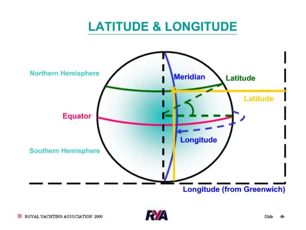
If you were pilot of a plane or captain of a ship, before going from point A to point B, what do you need to do first? • You need flight plan or plot a course. What are we plotting? We are plotting specific points on a grid. • An imaginary set of parallel lines or a grid is used to help find a location on Earth.
Coordinate System • These set of parallel lines are called a coordinate system. • This coordinate system used to find points on Earth is similar to the coordinate system used in math.
Coordinate System Just like in math, we use two points or coordinates to find a location on a map.
The two points used is Latitude and Longitude • Latitude- lines that run east to west above or below the equator. Latitude lines are parallel to each other running East to West. W E W E W E http://academic.brooklyn.cuny.edu/geology/leveson/core/linksa/latitude.html
Latitude Notice the 30 degrees angle formed at the center of Earth. As mentioned before, latitude is the distance in degrees north or south of the equator.
The latitude of Martin Van Buren High School is about 40.72 deg Latitude North
The second coordinate point is Longitude. • Longitude- lines that run north to south, east or west of the Prime Meridian (0o). Longitude Lines are parallel to each other running north to south. http://academic.brooklyn.cuny.edu/geology/leveson/core/linksa/longitude.html
The longitude of Martin Van Buren High School is about 73.74 deg Longitude West.
Latitude Longitude • Finally! When combining latitude and longitude, we have our grid or coordinate system. • Just like in math, we plot our points based on two coordinates http://academic.brooklyn.cuny.edu/geology/leveson/core/graphics/mapgraphics/longlat2.gif
So for Martin Van Buren, our coordinates are 40.72 deg Latitude N, 73.74 deg Longitude W
Write a quick summary of what we discussed today. What was something new you learned today? What is something that you did not understand? • Do you feel confident about the class so far?