Download
1 / 8
80 likes | 226 Vues
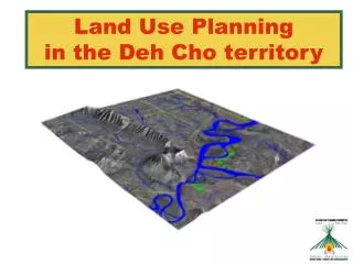
Presentation to Stakeholder and Local Community Workshop #3 March 6, 2009. Spatial Analysis in the Atlin/Taku Land Use Planning Process. Overview. Role of spatial analysis in the LUP process Approach to Spatial Analysis Introduction to Decision Support Tool

E N D
Presentation to Stakeholder and Local Community Workshop #3 March 6, 2009 Spatial Analysis in the Atlin/Taku Land Use Planning Process
Overview • Role of spatial analysis in the LUP process • Approach to Spatial Analysis • Introduction to Decision Support Tool • Opportunities for stakeholder engagement • Timelines • Questions, discussion
Role of Spatial Analysis in LUP Process • The Culturally and Ecologically Sustainable Management Framework (CESMF) lays out the anticipated components of the land use plan • One of the main components will be land use zones • Zoning distributes land uses across the plan area so as to achieve a balance and reconcile competing interests to the greatest extent possible
Role of Spatial Analysis in LUP Process • Goals and objectives provide resource management direction across the entire plan area • Additionally, more area-specific resource management direction may be developed for particular zones, such as: • Acceptable activities, including management strategies • Planning or process requirements • Other kinds of spatial products may also be developed to guide particular kinds of activities that span multiple zones or apply only to part of a zone,for example: • Exploration guidelines applicable to goat winter range
Approach to Spatial Analysis • ‘Spatial analysis’ refers to anaylzing and interpreting spatially defined information and their interaction • The TWG will be developing draft spatial outputs based on a detailed review and discussion of multiple mapped data sets and their interaction: • Resource Atlas or other mapped information provided • Community Values layer • References to important areas from interest statements • Input from stakeholder workshops • Draft spatial outputs will provide a solid basis for further discussions aimed at achieving a balance and reconciling competing interests
Introduction to Decision Support Tool • BC and the TRTFN will be using a GIS tool to assist in developing and evaluating draft spatial outputs • The GIS platform we have developed is referred to as the Decision Support Tool (DST) • Uses GIS to display and overlay maps of different values • Uses the power of GIS to generate multiple land use zoning scenarios • Allows analysis of each ‘scenario’ to check the extent to which values have been incorporated • Use of the DST enables the TWG to generate multiple zoning scenarios to inform further discussion and report back on how some values might be addressed • This approach reflects current best practices in land use planning
Opportunities for Stakeholder Engagement • Over the first two workshops, stakeholders have had the opportunity to review and provide input into the Resource Atlas • Stakeholders have been encouraged to provide information on the spatial extent of their interests in discussions over the last few weeks • Workshop participants will also be invited to provide some initial input on the distribution of their interests across the plan area through a hands-on exercise tomorrow • The TWG anticipates generating draft spatial information in the next several months, allowing the TWG to bring forward draft zoning products for detailed review by stakeholders at the June workshop • The TWG is also willing to arrange meetings to discuss stakeholders’ spatial interests