Ancient Anastasian Wall in Thrace, Turkey
100 likes | 194 Vues
The Anastasian Wall is a stone fortification built by the Byzantines in the late 5th century to protect Constantinople. Stretching 56 km, it served as an additional defense system against invaders from the west.

Ancient Anastasian Wall in Thrace, Turkey
E N D
Presentation Transcript
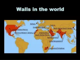
THE ANASTASIAN WALLS The Anastasian Wall (Turkish: Anastasius Suru, Greek: ΑναστάσειοΤείχος) or the Long Walls of Thrace (Uzun Duvar, Μακρά Τείχη της Θράκης) is an ancient, stone and turf fortification located 65 km west of Istanbul, Turkey built by the Byzantines during the late 5th century. Originally some 56 km long, it stretches from Evcik İskelesi at the Black Sea coast across the Thracian peninsula to the coast of the Sea of Marmara at 6 km west of Silivri (ancient Selymbria). The wall was part of an additional outer defense system for Constantinople, capital of the Eastern Roman Empire and probably continued in use until the 7th century. The wall was named after the Emperor Anastasius I (ruled 491 – 518). However, there is evidence that the fortification already existed in 469 during the reign of Leo I (457 - 474) and in 478 in the era of Zeno (476 – 491), and it was maintained and renewed by Anastasius in the time from 507 to 512. The wall had a thickness of 3.30 m and a height over 5 m. It was built complete with towers, gates, forts, ditches and a military way to protect Constantinople from invasions from the west by Huns, Slavs and Bulgars. A rectangular castrum with dimensions of 250 by 300 m existed also in the central section of the wall. It is known that the wall had only a limited effectiveness, and the barbarians penetrated it many times, because the fortification's length made it difficult to defend the wall completely by a limited garrison, and also because the wall was not sufficient strong due to its construction in hurry. The wall fell into ruin after it was abandoned in the 7th century because of the difficulty of keeping it manned and repaired. Over the centuries, the stone of more than half of the total length was reused in other local buildings. It is best preserved in the woodlands of the northern sector. The Anastasian Wall is an almost unknown example of monumental linear fortification dating from antiquity in continental Europe, next only to Hadrian's Wall (122 AD) in England in its complexity.
THE ANTONINE WALL Construction of the Antonine Wall began in 142 AD, during the reign of Antoninus Pius, by Quintus Lollius Urbicus and was completed in 144. The wall stretches 60 kilometres (37 miles) from Old Kilpatrick in West Dunbartonshire on the Firth of Clyde to Bo'ness, Falkirk, on the Firth of Forth. The wall was intended to replace Hadrian's Wall 160 km (100 miles) to the south, as the frontier of Britannia, but while the Romans did establish temporary forts and camps north of the wall, they did not conquer the Caledonians, and the Antonine Wall suffered many attacks. The Romans called the land north of the wall Caledonia, though in some contexts the term may mean the area north of Hadrian's Wall. The Antonine Wall, looking east, from Barr Hill between Twechar and Croy The Antonine Wall was inferior to Hadrian's Wall in terms of scale and construction, but it was still an impressive achievement, considering that it was completed in only two years, at the northern edge of the Roman empire in what they perceived as a cold and hostile land. The wall was typically an earth bank, about four metres high, with a wide ditch on the north side, and a military way or road on the south. The Romans initially planned to build forts every six miles, but this was soon revised to every two miles, resulting in a total of 19 forts along the wall. The best preserved but also one of the smallest forts is Rough Castle Fort.
THE LAND WALLS The Land Walls The Walls of Byzantium and Constantine The original fortifications of the city were built in the 7th century BC, when it was founded as Byzantium by Greek colonists from Megara, led by the eponymous Byzas. At the time the city consisted of an acropolis and little more. Byzantium, despite being a prosperous trading post, was relatively unimportant during the Roman period, but featured prominently in the civil war between Septimius Severus and Pescennius Niger, holding out a Severan siege for three years (193-96 AD). As punishment, Severus had the strong walls demolished and the city deprived of its status. However, soon after he rebuilt it, appreciating the city's strategic importance, and endowed it with many monuments and a new set of walls, increasing its area. When Constantine the Great moved the capital of the Empire to Byzantium, which he refounded as Nova Roma, he greatly expanded the new city by building a new wall about 2.8 km (15 stadia) westwards of the Severan wall and incorporating even more territory. Constantine's fortification consisted of a single wall, reinforced with towers at regular distances, which began to be constructed in 324 and was completed under Constantine II. The approximate course of the wall is known, running from the area of the Plateia Gate of the Golden Horn sea walls to near the Gate of St. Aemilianus on the Propontis walls (see section on the Sea Walls below). The wall survived during much of the Byzantine period, even though it was replaced by the Theodosian Walls as the city's primary defence; however, only the Old Golden Gate still survived to late Byzantine times, until destroyed by an earthquake in 1509. Already by the early 5th century however, Constantinople had expanded outside the Constantinian Wall, in the extra-mural area known as theExokionion.[4]
The Theodosian Walls The Theodosian Walls Restored section of the Theodosian Walls at the Selymbria Gate. The Outer Wall and the wall of the moat are visible, with a tower of the Inner Wall in the background In 408, during the reign of Emperor Theodosius II, construction began on a new wall, about 1,500 m to the west of the old, which stretched for 5,630meters between the Sea of Marmara and the suburb of Blachernae near the Golden Horn. The new wall, which became known as the Theodosian Wall (Greek Theodosianon Teichos), was built under the direction of Anthemius, the Praetorian prefect of the East, and completed in 413. The walls stretched for about 5.5 km from south to north, from the Marble Tower, Turkish Mermer Kule (in Greek Pyrgos Basileiou kai Kōnstantinou, "Tower of Basil and Constantine") on the Propontis coast to the Blachernae, ending at about the area of the Palace of the Porphyrogenitus (known in Turkish as Tekfur Saray), where they adjoined the later walls of Blachernae. New Rome now enclosed seven hills and justified the appellation Eptalofos, like Old Rome. On November 6, 447, however, a powerful earthquake destroyed large parts of the wall, and Theodosius II ordered the urban prefect Cyrus of Floros (sometimes referred to as Constantine) to supervise the urgent repairs, as the city was threatened at the time by Attila the Hun. Cyrus employed the city's dēmoi (more widely known as "Circus factions") in the work, and succeeded in restoring the walls within 60 days, as testified in two inscriptions in Greek and Latin on the Mevlevihane Gate. At the same time, a second outer wall was added, and a wide ditch opened in front of the walls.
The Sea Walls The first seaward walls were ordered built by Constantine I along with the main land wall, and enclosed the city on the sides of the Propontis (Sea of Marmara) and the gulf of the Golden Horn (Chrysoun Keras), but scant information survives regarding them. It is very likely, however, that the later walls followed their course. In 439, after the initial enlargement of the city, Theodosius II ordered the then-Praetorian prefect of the East, Cyrus
The Walls of Galata • Galata, then the suburb of Sykai, was not fortified during most of the Byzantine period, save the great tower that guarded the chain extending across the mouth of the Golden Horn. However, after the sack of the city in 1204, Galata became a Venetian quarter, and later a Genoese extraterritorial colony, effectively outside Byzantine control. Despite Byzantine opposition, the Genoese managed to surround their quarter with a moat, and by joining their castle-like houses with walls they created the first wall around the colony. The Galata Tower, then called Christea Turris ("Tower of Christ"), and another stretch of walls to its north were built in 1349. Further expansions followed in 1387, 1397 and 1404, enclosing an area larger than that originally allocated to them, stretching from the modern district of Azapkapı north to Şişhane, from there to Tophane and thence to Karaköy. After the Ottoman conquest, the walls were maintained until the 1870s, when most were demolished to facilitate the expansion of the city. Today only the Galata Tower, visible from most of historical Constantinople, remains intact, along with several smaller fragments.