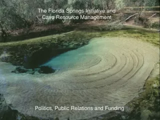
The Florida Gazetteer Initiative
The Florida Gazetteer Initiative Presented by Stephanie Haas, Assistant Director, Digital Library Center, University of Florida and David Stage, FGDC Cadastral Subcommittee, Eastern Cadastral Coordinator, FL Gazetteer Consultant History – Issues

The Florida Gazetteer Initiative
E N D
Presentation Transcript
The Florida Gazetteer Initiative Presented by Stephanie Haas, Assistant Director, Digital Library Center, University of Florida and David Stage, FGDC Cadastral Subcommittee, Eastern Cadastral Coordinator, FL Gazetteer Consultant
History – Issues Place name issues have impacts far beyondthe Geography community • David – History and Future Directions • Stephanie - Implications in the library/museum environment. Mapping (GIS) Community Business Issues • Place name for maps • Tags vs. Named Place Centroids • Currency of GNIS • Points vs. Footprints for spatial analysis
Recent Florida Gazetteer History • 1997 – 2000 • Library, Museum and GIS Community Began a Dialog • 2000 - Business Requirements Assessment (St. Petersburg Workshop) • Feds: USGS GNB, Census, USGS Field Offices, Army Corps of Engineers • (Libraries and Museums) FL Biological Consortium • State Agencies and Water Management Districts • Alexandria Digital Library Project • Identify issues • Currency of Data • Feature Types unique to Florida (Islands > hammocks) • Location of Named Features (Points vs. Footprints) • Technical • Acquisition of meaningful locations • Implementation • Administrative and Funding • Stewardship of data • Governance
More Recent History • 2001 – 02 Implementation Strategy (USGS Funding) • Workflow & Footprint Issues • Identified Potential Stewards • Systems Design & Implementation Plan • 2002 – 03 Built FL GNIS • Comprehensive Everglades Restoration Program (CERP) • Army Corps of Engineers & SWFWMD – Gazetteer in CERP Workplan • Built FL GNIS • Developed a Conceptual Scheme for Footprint Implementation • LSTA grants written- Florida Digital Gazetteer (2002); Mapping Florida’s Historic Place Names (2003) • 2004 - SFWMD acquired funding to implement a local gazetteer. • Will not fund an abstract idea or coordination • Problem – Document Management • Build footprint database • Build Application • Address Transfer protocols and synchronization with GNIS and FLGNIS • 2004 – 05: Establish Florida Geographic Names Board & Implementation • Test Implementation strategy developed in 2002 • Develop Training Program
SEVEN RESEARCH ISSUESAlexandria Digital Library Project SFWMD Gazetteer – GIS Solutions Green – Almost Resolved; Red – Problem Area • Discovery (Structured) • Classes of data without place names (remote sensing data). • Grid based systems • Discovery based on textual placename matching is unreliable. • Foot prints • Gazetteer Integration:Seamless and Invisible to application • Spatial Rankingof Query Results • Strategy for building footprints (Points ->Footprints) • Google Ranking: Atlas of the World coming to the Top • Hausdorf Distance Function – Image Recognition
SEVEN RESEARCH ISSUESAlexandria Digital Library Project • Data Typing (architecture) – Standard Categories • Identifier • Subject, Title, Assigned Term, Originator • Location, Time Period • Object Type, Feature Type, Format • Scalability– Large Volumes of Spatial Data – Imagery • Spatial context – Human Interface • Resource Access • GIS • Map Server • Grid Based System
FOOTPRINTSFunding Driver • Funding Driver • Applications to meet business requirements • Spatially enable spatially challenged databases • Example • SFWMD Document Management System ($200,000 over 3 years) • Place Name provides link to GIS
Future DirectionsIssues to Address • Administrative Support and Guidance (National and Local) • Names Board - (National - GNB & Local - FLGNB) • Establish Procedures • Training (I didn’t know you could.) • Transfer protocols • Research Strategy (National) • Criteria for the use of different types of Geometry (National and Local) • Points, Bounding Boxes, Lines, Polygons, Grid cells • X Step Approach to Improving Geometry
Future DirectionsIssues to Address • Support the User Community Spatial Needs (National and Local) • Applications to meet business requirements • Document management systems • Spatially enable spatially challenged databases • Footprint Warehouse • Multiple footprints • Visualization • Current • Temporal (historical) • Query Footprints • Fuzzy Footprints • Stewardship (Local) • Driven by applications
IMPACT ON LIBRARIES AND MUSEUMS • The form of geographic entry has a significant impact on the information/library world: • Access issues: library catalogs, databases • Metadata creation: subject headings, lat/long coordinates • Interoperability across discipline boundaries • Full text searching initiatives
LIBRARY CATALOG ACCESS Libraries use GNIS as the primary authority for U.S. place names. The rule of thumb in library cataloging is to qualify place names by country with certain exceptions including the US where 1st order political divisions are used, e.g., Tampa Bay (Fla.) Headings are created for works in hand.
The format for most U.S. place names in library catalogs is the place followed by a state abbreviation in parenthesis. If duplicate names exist, the county is added. , e.g., Orange Lake (Alachua County, Fla.)
If a name is not found in GNIS, other resources are used to develop the name which is then submitted through the Subject Authority Cooperative Program (SACO) to the Library of Congress, but not to GNIS! Authority Record for Jacksonville in LC system
SURFACTANT BOX 1:In a recent survey, catalogers were asked: “When you create subject headings for U.S. places that aren’t in GNIS, do you submit the names to GNIS? All seven respondents answered: NO. When asked why not? The unanimous answer was “I didn't know that you could do that.” RINSE: Having catalogers contribute their work to GNIS would build a resource used by both communities, as well as nationally and internationally. SPIN: SACO at LC and GNIS could discuss collaborating.
METADATA CREATION Increasingly, access to geographic/spatial data and avoidance of duplicating costly data gathering are priorities throughout all levels of US government.One of the key difficulties for research communities in developing metadata is defining appropriate geographic access.The following screens show some of the variations.
Federal Geographic Data Committee’s - Digital Geospatial Metadata—Geographic element Geographic the quantities of latitude and longitude which define the position of a point on the Earth's surface with respect to a reference spheroid. • Shoreline Data Profile of the CSDGM • Biological Data Profile of the CSDGM
DUBLIN CORE (the scarecrow version of MARC) was developed as the Web resource metadata
INTEROPERABILITY QUESTIONS: What happens when we try to search across metadata schemes? In 1997, an IMLS grant “Linking Florida’s Natural Heritage” was funded to use the Z39.50 protocol to tiemuseum specimen records to MARC bibliographicrecords. We found that the critical semantic elements missing in MARC were taxonomic and geographic.
Author, etc.: Killam, Kristie A. Title: The reproductive biology, age, and growth of the blacktip shark, Carcharhinus limbatus (Valenciennes) near Tampa Bay, Florida / by Kristie A. Killam. Published: 1987 Description: x, 109 leaves : ill. ; 29 cm. Notes: Thesis (M.S.)--University of South Florida, 1987. Contents: Introduction -- Literature review -- Materials and methods -- Results and discussion -- Summary -- List of references Subjects, general:NO SUBJECT Blacktip shark--Florida--Reproduction. ACCESS TO TAMPA Blacktip shark--Florida--Growth. BAY! Carcharhinus limbatus.
GEOGRAPHIC ENHANCEMENTS TO MARC Author, etc.: Killam, Kristie A. Title: The reproductive biology, age, and growth of the blacktipshark, Carcharhinus limbatus (Valenciennes) near Tampa Bay, Florida [electronic resource] / by Kristie A. Killam. Published: 1987 Description: x, 109 leaves : ill. ; 29 cm. Notes: Thesis (M.S.)--University of South Florida, 1987. Geographic location: United States Florida Hillsborough Tampa Bay Westernmost longitude:-82.5725 Northernmost latitude:27.68833 Subjects, other: Tampa Bay--3100206 Hillsborough--12057 Added: GNIS hierarchy, lat/long coordinates, and HUC, FIP codes
SURFACTANT BOX 2:Although there is a rising awareness of the need to provide compatibility between various metadata formats, the geographic element is probably one of the least useful in library metadata. RINSE: Consider revising and/or incorporating additional geographic access elements to MARC records to facilitate data exchange. Geographic search interfaces need to be developed for online catalogs. SPIN: Add a preformated GNIS hierarchy or lat/long to LC geographic subject headings that could be cut and pasted into cataloging records as they are created, e.g, 752: : |a United States |b Florida |c Hillsborough |d Tampa Bay or 034:1 : |d -82.5725 |f 27.68833
FULL TEXT SEARCHING INITIATIVES The usefulness of full text research documents will be greatly enhanced when users can enter the text through a map interface.
Roving Naturalists: Pilot Project on the Bartrams’ in Florida Map of the Road from Pensacola in W. Florida to St. Augustine in East Florida 1778 associated with John Bartram’s Diary of a Journal through the Carolinas, Georgia, and Florida from July 1, 1765 to April 10,1766
LC authority GNISauthority
SURFACTANT BOX 3: The last comprehensive update of Florida named features was done in 1987. Until accurate, comprehensive, and spatiallyenhanced place name authorities are available, all projects requiring geographic functionality will reflect existing inadequacies. RINSE: Increasingly digital projects have a geographic component. SPIN: Enlist all of the stakeholders including library catalogers who are involved in U.S. place name issues to help build GNIS.