Download
1 / 19
190 likes | 502 Vues
NOAA Satellite and Information Service GOES Constellation Status. Chris Wheeler GOES Team Lead Office of Satellite Operations National Environmental Satellite, Data, and Information Service. Agenda. GOES On-Orbit Configuration On-Orbit Configuration GOES Spacecraft Overview

E N D
NOAA Satellite and Information ServiceGOES Constellation Status Chris Wheeler GOES Team Lead Office of Satellite Operations National Environmental Satellite, Data, and Information Service
Agenda • GOES On-Orbit Configuration • On-Orbit Configuration • GOES Spacecraft Overview • GOES Spacecraft Status • GOES-10 Decommission Plan • GOES East Transition • Imager Stray Light Effects • GVAR Changes for GOES-14 and GOES-15
GOES Spacecraft Overview GOES I-M Series: Built by Space Systems / Loral in Palo Alto, CA Based on Loral 1300 bus series Design Life: 5yrs GOES N-P Series: Built by Boeing Satellite Systems in El Segundo, CA Based on Boeing 601 series Design Life: 10yrs (bus) / 5yrs (instruments)
GOES-O/14 Status • Launched June 27, 2009 • Currently in on-orbit test at 89.5°W • All systems operating nominally • MAGPD Telescope 5 noisy detector • Drift to 105°W planned for 11/4/09 – 11/20/09 • NOAA Science Test planned for 11/30/09 – 1/4/10 • Plan to continue operating XRS while in earth-pointed “storage”
GOES-N/13 Status Launch Date: May 24, 2006 Orbital Location: 105°W longitude Designation: On-Orbit Spare Solar X-Ray Imager CCD detector partial damage during X9 solar flare and cosmic particle hit. N2 thruster anomalous thrust level. Thruster use restricted. No user impact. XRS capacitor short
GOES-M/12 Status Launch Date: July 23, 2001 Orbital Location: 75°W longitude Designation: Operational East Energetic Particle Sensor (EPS) channels noisy. X-ray positioner electronics failed. XRS cannot track Sun. Solar X-Ray Imager high voltage power supply failed. Thruster 2B oxidizer valve leak. “B” side thrusters isolated.
GOES-L/11 Status Launch Date: May 3, 2000 Orbital Location: 135°W longitude Designation: Operational West X-ray positioner electronics failed. XRS cannot track Sun. Reduced battery 1 capacity. Potential impact to user services during eclipse Imager/Sounder primary sensor data transmitter failed. Switched to redundant transmitter Command receiver B failed; Receiver A operating nominally
GOES-K/10 Status Launch Date: April 25, 1997 Orbital Location: 60°W longitude Designation: Operational Atlantic/South America Sounder Filter Wheel stalled Energetic Particle Sensor (EPS) channels noisy. No fuel remaining for stationkeeping Solar array forward mode failed. Spacecraft Inverted and solar array run in reverse. Data Collection Platform Interrogate (DCPI) Primary transmitter failed. Switched to Redundant transmitter.
GOES-10 Decommission Plan • GOES-10 has reached end of fuel life • Remaining fuel reserved for de-orbit maneuvers • De-commission activities scheduled for December 1-2, 2009 • GOES-10 instruments and communication services will be de-activated Dec. 1 at approx. 12:30z (7:30am EST) • Dedicated South America imaging operations will be interrupted • Series of maneuvers will be performed to boost GOES-10 300km above geosynchronous orbit • De-commission objectives: • Boost orbit 300km above geosynchronous altitude • Deplete remaining fuel • Power off electro-mechanical systems • Disable battery charging • Turn off all transmitters to prevent RF interference • Following decommission, GOES-10 is not recoverable
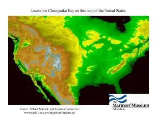
South America Coverage • NOAA/NESDIS operating GOES-10 at 60 degrees West since December 2006. • Provides continuous GOES coverage of South America during GOES EAST rapid scan operations. • Positive impact to South American severe storm and flash flood forecast and warnings. • GOES-10 at end of fuel life and must be de-orbited. • NOAA has received requests to continue South American support through multiple international organizations. • NESDIS recommendation to utilize GOES-12 for South America coverage by June 2010 • Can provide dedicated South America coverage in time for the North Atlantic hurricane season • GOES-12 east-west fuel available for 3 years of operation • No fuel remaining for inclination control • Awaiting approval from NOAA Headquarters
Draft GOES-13 replaces GOES-12 in April 2010 Minimum impact to GOES constellation fly-out scenarios Goal is to complete transition prior to 2010 hurricane season Similar sequence to GOES-8/12 transition Provides significant test period for OSDPD and direct users to evaluate ingest systems Does not require users to re-point antenna systems during drift period Incorporates a single GVAR switch from GOES-12 to GOES-13 If approved, GOES-12 would be available for South America coverage beginning in May 2010 Proposed GOES East Transition GOES-12 Drift from 75 to 60 GOES-13 Drift from 105 to 75
1/19 GOES-13 Return to Normal Mode Imager, Sounder, SEM activated SXI remains off 1/21 Image Navigation Start-up (4 days) 1/25 Begin GOES-13 execution of GOES East Schedule 2/9 Perform GOES-13 Annual inclination maneuver 2/17 Conduct GOES-13 Operations Readiness Review 2/23 Start GOES-13 Eastward Drift from 105°W to 75°W 3/8 Near 99°W; Activate GOES-13 SXI/MDL 4/14 Near 81°W; GOES-13 becomes GOES-East Stop GOES-12 GVAR GOES-13 GVAR relayed through GOES-12 Users do not re-point antenna 4/26 Stop GOES-13 Drift at 75°W GOES-13 GVAR relayed through GOES-13 Switch ancillary COMM services from GOES-12 to GOES-13 GOES East Transition Timeline
Imager Stray Light Effects • GOES I-M series instruments had a solar keep-out-zone restriction when the sun was < 7° from scan frame • Imager/Sounder frames cancelled to prevent overheating of the secondary mirror assemblies • GOES N-P instrument modifications eliminate solar keep-out-zone effects • GOES N-P design allows for continuous imaging operations through eclipse • Verified through post-launch testing and GOES-13 operational periods • However….. • Solar stray light contamination is observed when the sun is <10-15 degrees from the image frame. • Comparative tests performed on GOES 11-13 in April 2009 show that stray light performance is the same for GOES 11-13 • Subsequent testing on GOES-14 during Fall 2009 eclipse season show similar performance on GOES-14
Why not scan away from contaminated data? Imager Stray Light Mitigation Options include: • Take all images regardless of Sun position. Let users decide which images to use • Considered undesirable • Cancel image when the Sun is close to the frame boundary • Re-introduces keep-out-zone • Results in a lot of frame cancellations • Undesirable • Scan away from the Sun • Scan partial or shifted frames • Short-term approach • Apply an L1b algorithmic correction to remove stray light prior to GVAR broadcast • NASA/NOAA/ITT study underway • Long-Term approach Corrected Image Original Image See poster presentation for more info
GVAR Changes for GOES-O/P • Background • GOES-O/P Imagers have additional 8th IR detector • Imager factory coefficients (including instrument nadir positions) previously copied from Block 0 to Block 11 for GOES-12 and beyond • Beginning with GOES-O, factory coefficients were removed from Block 0. • Issues • Instrument offsets are important for image navigation • Block 11 is transmitted infrequently • User ingest systems were not updated to reflect GVAR changes • Resolution • Instrument offsets are being copied back to previously spare locations in Block 0 • Effective early November 2009
GOES Calibration Information • GOES Calibration Website http://www.oso.noaa.gov/goes/goes-calibration/index.htm • For Imagers and Sounders of current and previous operational satellites, contains up-to-date (from instrument developer) • Calibration parameters, and • Spectral response functions • Recent update for GOES-13 Imager channel-6 Spectral response functions • A shifted and current operational version approved by NOAA/NESDIS Calibration Oversight Panel (CalPOP) • Recent addition • GOES-O calibration parameters and spectral response functions • Pending addition • GOES-P calibration parameters and spectral response functions