Download

1 / 11
110 likes | 236 Vues
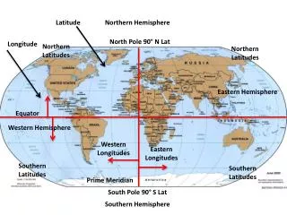
This text explores the concepts of geographical coordinates, specifically focusing on longitude and latitude measures in Iowa, which is situated at approximately 42.0° North and 93.0° West. It covers the calculation of great circle distances along longitudinal and latitudinal lines, the implications of Earth’s radius, and the specific changes in coordinates measured in feet for minute changes in latitude and longitude. The application of spherical trigonometry and simple surveying calculations for short distances is demonstrated to provide accurate estimations of distances.

E N D
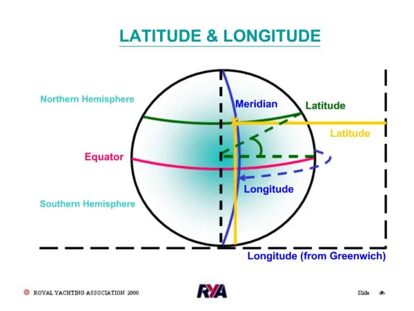
Longitude • North - South Meridians base point of world system is Greenwich, England Iowa - approximately 930 West
Latitude • Measured from the Equator • Iowa - approximately 42 0 North
Great circle distances(assume a round world) • Along a longitudinal line the Radius of the earth is approximately • R = 3959 miles or • R = 6371 kilometers • Distance along 1 degree of longitude: • L = R * theta where theta is in radians • L = 3959 * (1 deg/ 57.2958 deg/rad) • L = 69.09 miles
Great circle distances(assume a round world) • Along a latitudinal line the Radius of the earth about the poles is a function of the latitude: • Radius(at Lat. y) = Radius *cos(Latidude) • Distance =( R at Lat Y) * theta • At 420 , lat, R = 3959 miles * Cos (420) • =2942 miles • In 1 deg, Dist = 2942 *1/57.29 =51.35 mi
Navigational GPS at ISU • Records to nearest 0.001 minute • ___________________ • A) What is the distance in feet for 0.001 minute change in the longitude at a latitude of 420? • What is the distance in feet for 0.001 minute change in the latitude of 420 (or any other latitude)?
Bearings from flat-earth society Spherical trigonometry is used to obtain precise assessment of distance. HOWEVER, over short distances, Eastings and Northings from surveying will give good estimates: Point 1: Latitude 42d 17.369’ N, Longitude: 93d 43.614’ W Point 2 Latitude 42d 18.749’ N Longitude: 93d 44.865’ W Angular change Delta North = 1.380’ (minutes) to north Delta West = 1.251’ to west
Bearings from flat-earth society Delta North = 1.380’ (minutes) to north Delta West = 1.251’ to west Distance north: Radius = 3959 miles along meridian L = R * theta where theta is the central angle L = 3959 mi * 5280 ft/mi * 1.380’/ (60’/deg) / (57.2958d per radian) L = 8391 feet Distance West - consider using average latitude of the two points Average latitude = 42d 18.059’ Radius = 3959 * cos (42d 18.059’) = 2928 miles L = 2928 mi *5280 ft/mi * 1.251min/ (60’/deg) / (57.2958d per radian) L = 5626 feet
Bearing of line Dist north = 8391 feet Dist. West = 5626 feet Bearing = atan( 5626/ 8391) or N 33d 50’ W Total Distance = 10,103’ This estimate of distance is in error by less than 0.00002 feet compared to spherical trigonometry.