Unveiling the Mid-Atlantic Cold Pool: Gliders Mapping Ocean Dynamics
Delve into the realm of the Cold Pool, a phenomena impacting marine ecosystems, as ocean gliders meticulously collect data along the Mid-Atlantic coast. Explore how these autonomous devices work and their pivotal role in forecasting oceanic variability.

Unveiling the Mid-Atlantic Cold Pool: Gliders Mapping Ocean Dynamics
E N D
Presentation Transcript
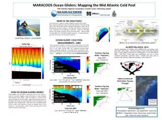
MARACOOS Ocean Gliders: Mapping the Mid Atlantic Cold Pool Mid Atlantic Regional Association Coastal Ocean Observing System WHAT IS THE COLD POOL? The Cold Pool is a swath of bottom-trapped remnant winter water that is observed between Cape Cod and Cape Hatteras from late spring (when the surface water warms ) through early autumn (when storms homogenize the water column ). The May 2013 bottom temperature map produced by the ESPRESSO numerical model (to the right) defines the spatial variability of the Cold Pool Water . Because CPW strongly affects the Mid Atlantic Bight ecosystem, including fisheries , we seek to forecast its time-space variability. Launching a Slocum ocean glider OCEAN GLIDER COLD POOL MEASUREMENTS : 2007 These autonomous gliders are able to very slowly (about 1/2 mph!) saw-tooth their way along a user-determined horizontal trajectory (E.g., to the right). During 2007, we conducted multiple glider missions (typically lasting for 3-4 weeks) which measured 6 cross-shelf “slices” of the Cold Pool during its Massachusetts to New Jersey transit. [SEE Leg -1 - south of Massachusetts EXAMPLES BELOW] What is in an autonomous underwater glider? Surfacings - every few hours - oC GLIDER PALOOZA: 2013 During September & October 2013 MARACOOS coordinated more than eight ocean glider missions between Nova Scotia and Georgia. Half of those gliders measured the disintegration of the Mid Atlantic Bight Cold Pool. These data were assimilated into one or more research operational numerical ocean models that were able to produce near real-time maps and forecasts of the Cold Pool. Northern Zig-Zag Glider Trajectory : May 2007 (Leg-1 highlighted) Late Spring 2007 Leg-1 glider “slice” through the “new” Cold Pool (deep blue) ….temperature (oC) minimum located. UMass Dartmouth 2013 Glider Palooza “Triangle” ~120m |-------------- 1 kilometer --------------| Northern Zig-Zag Glider Trajectory : Early Fall 2007 (Leg-1 highlighted) HOW DO OCEAN GLIDERS WORK? Ocean gliders sink and “glide” downward from the sea surface – when its computer triggers a piston that draws in some seawater and therefore extra weight. Near the bottom, a reverse action causes the glider to rise and “glide” upward towards the surface. As the glider saw-tooths its way through the ocean it measures ocean properties (e.g., temperature) . Every few hours, the glider pauses at the surface and transmits its data via satellite back to the laboratory – thus providing us with a near real-time picture of the internal structure of the ocean. Early Fall 2007 Leg-1 glider slice through the “aging” Cold Pool ….note 3oC CP warming Acknowledgements: These glider operations are supported in part by NOAA’s Integrated Ocean Observing System Pgm. and Office of Naval Research