Download
1 / 31
320 likes | 540 Vues
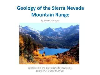
Angelique Northcutt, Garrett Owen, Chris Perdue, Bo Price, Tory Rogers. Geology of the Precambrian Sangre De Cristo Range and Picuris Mountains of New Mexico. Where are we going?. -The Sangre de Cristo fault is a west dipping fault in New Mexico

E N D
Angelique Northcutt, Garrett Owen, Chris Perdue, Bo Price, Tory Rogers Geology of the Precambrian Sangre De Cristo Range and Picuris Mountains of New Mexico
-The Sangre de Cristo fault is a west dipping fault in New Mexico -It forms the border between the Sangre de Cristo Mountains and the San Luis Basin. -The Sangre de Cristo fault extends from poncho Pass, Colorado to near where we’ll be in Taos, NM. Background
-The section we will be focused on extends from the San Pedro Mesa creek south to the intersection with the Embudo Fault at Rio del Rancho which is about 8 km south of Taos. -The Sangre de Cristo is part of the more recent Rio Grande Rift. -It is a normal fault that moves less than 0.2 mm/year. Background
-The Basement rocks in this location are Precambrian in age. -The rocks of Colorado and Northern New Mexico are juvenile Volcanic- Plutonic, Ocean Arc rocks that are approximately 1.78 to 1.65 billion years old. -In New Mexico these rocks have been assigned to the Yavapi and Mazatzal provinces. - These Rocks were deformed during 2 major Proterozoic orogenies. History
-First the Colorado Orogeny has a U-Pb date that goes through 1.78-1.75 Ga. -It was a prolonged thermotectonic episode resulting from collision, subduction, and continued convergence. -This occurred along the paleosuture known as the Cheyenne Belt along the Archean Wyoming Province. History
-Second the Berthoud Orogeny has a U-Pb date that started 1.45 Ga and went through 1.40 Ga. -This was a thermo tectonic episode that produced NE trending ductile shear zones and related folds. -The mechanism powering this Orogeny was granitic plutonism. -This Orogeny also formed many high grade metamorphic rocks through generally pervasive metamorphism. History
-Isoclinal folding -East-west strike -Southward dips (60-70 degrees) Pre-Cambrian rocks
-2 major anticlines and 2 major synclines -Wave lengths 1 to 2 miles -Doubly plunging (~20-30 degrees) Folds
Pilar Anticline -Widely displaced by the Pilar-Vadito tear fault -Slightly overturned to the north -Axial plane dipping south (60 degrees) Hondo Syncline -Overturned -Axial plane dips south (60-70 degrees) -Eastern segment plunges 30-40W -Western segment plunges 10-20E Folds
Copper Hill Anticline -Axial plane plunges 30-35W -N85W, 50W -Can be traced 9 miles east of Copper Hill Harding Syncline -Structural detail is obscure -Strikes E-W -Plunge ranges 25-17NE Folds
-Abundant/wide variability in pre-Cambrian rocks -3 predominant sets -N10W to N10E (almost vertical) -N50W to N70W (dipping steeply NE) -N20E to N40E (dipping steeply SE) Jointing
-N-S joints followed almost exclusively by copper ore-bearing quartz veins -Mineralization after granitic intrusion -Harding pegmatite estimated 800myo -Indicates time of jointing Jointing
-Conglomerate of the Vadito -Pebbles have average axial ratio of 1:2:3 -Shortest axis perpendicular to foliation -Some wedge-like shaped with apex oriented down the lineation -Pebbles in close contact have greater impacted shape Stretched Pebbles
Three Major Fault Systems • Picuris-Pecos fault system • Embudo transfer fault • Sangre de Cristo fault zone
Picuris-Pecos Fault System 84 km long fault system consisting of five parallel fault zones: • Picuris-Pecos-Major crustal boundary juxtaposing two Proterozoic rock sequences: the Hondo Group and the Miranda Granite • La Serna -East-down fault separating Miranda Granite and Picuris Formation • Miranda -North-striking strike slip fault • McGaffey -West-down branching fault splay • Rio Grande del Rancho -Kilometer-wide, west-down fault zone
Sinistral, antithetic transfer zone which forms border between the EspañolaBasin and the San Luis Basin • 64 km long fault thought to be part of Jemez lineament • Fault consists of two sections based on reversal of throw • Strike of N60E • Sinistral net slip rate of .15 mm/year Embudo Fault Zone
West-dipping normal fault that forms border between the Sangre de Cristo Mountains and the San Luis Basin • Beginning of Sangre de Cristo Fault forms the terminus of the Embudo fault • The southern area of the fault is divided into five sections. From north to south, the sections are: - San Pedro Mesa - Urraca - Questa • The northern three strike north-south - Hondo • Strikes N30W - Cañon • Strikes N20E Sangre de Cristo Fault Zone
Pre-Cambrian Formations: • The Hondo Group-The Pilar Formation-The Riconada Formation-The Ortega Formation • The Vadito Formation
The Ortega Formation • Estimated 2,500 ft. thick • Gray to very light gray in color • Mostly Quartzite • Thin beds of sillmanite - kyanite gneiss • Bands of schistose with muscovite • Tourmaline
Riconada Formation • -Richly micaceous foliated rocks • -Consists of four distinct beds: • Andalusite-biotite Hornfels bed-Muscovite and quartz matrix that contains biotite, nodular masses of quartz and andalusite • Staurolite Schist and Gneiss Bed- Soft and light gray in color micaceous matrix speckled with biotite, contains staurolite crystals Staurolite Andalusite
The Riconada Formation • Quartzite bed – Grayish white in color, contains glassy- white and translucent quartzite • Muscovite-quartz-biotite-garnet Phyllite bed- Muscovite rich phyllite containing garnet crystals and biotite, sheen that ranges from pearly gray to greenish
Pilar Phyllite Formation • Estimated 2,300 ft. thick • Black to gray-black in color with a gray sheen • Contains muscovite flakes • Quartz veins • Limonite masses
Occupies the southern 1/3 of the Picuris Range -Named after the village of Vadito • Best outcrops come from within a one-mile radius of the Harding Mine -Total thickness: 4,500 feet • Comprised of a Lower Conglomerate Member and an Upper Schist Member Vadito Formation
Marquenas Formation Total thickness: ~ 2,000 feet Composed of Quartz Conglomerate and Quartzite, Felsites and Meta-andesites Quartz conglomerate outcrops in a quarter-mile wide east-west belt near Picuris Canyon but grow sparser farther east Composed of gray coarse to pebbly Quartzite with fine-grained micaceous quartzite matrix Thickness of the Quartz Conglomerate: 500 - 1,000 feet
Marquenas Formation Felsites occur to the east and west of the canyon but appear to pinch out to the west along the Ortega-Vadito contact Composed of meta-rhyolite that grades into coarser granite representing partial replacement by granite Gray-white to pink-white and has a dense felsitic texture with micas and feldspars present Thickness of the Felsites: 50-100 feet
Marquenas Formation Meta-andesites occur abundantly to the south and east of the Harding mine Greenish-gray to gray-black in color Hornblende occurs in all of these rocks as prisms and give the variable darkness in color to them Rocks show strong pleochroism in thin-section. Represent thin-layered volcanic material of dacitic and andesitic composition
Schist Member Consists of a schist and phyllite composed of quartz-muscovite and a quartz-biotite granulite The schist is similar to the underlying conglomerate quartzite with more densely disseminated flakes of muscovite Phyllite is a lustrous, silvery-gray rock with stubby biotite porphyroblasts Granulite is fine-grained, sandy, and crudely foliated with micaceous surfaces with flakes of biotite Thickness: At least 1,250 feet and no more than 2,500 feet
Amphibolites The amphibolites found in the Vadito Formation are split into two zones based on lithology: -One of the zones occurs in the Lower Conglomerate and one occurs in the Upper Schist These amphibolites show effects of intrusion by granitic and pegmatitic magma Thickness: 750 feet in Lower Conglomerate, and 1,250 feet in Upper Schist