Enhancing Evacuation Route Planning through Spatial Data Mining and Teleconnections
This research explores compelling strategies for evacuation route planning by leveraging spatial data mining techniques and understanding teleconnections. The study examines both old and new plans, referencing key contributions from distinguished scholars, including Shashi Shekhar. It emphasizes identifying shortest paths and storing graphs in disk blocks. The analysis includes representative projects focused on location prediction, nesting site identification, and understanding spatial outliers in relation to various environmental factors, such as water depth and vegetation durability.

Enhancing Evacuation Route Planning through Spatial Data Mining and Teleconnections
E N D
Presentation Transcript
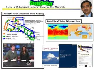
Spatial Datbases: Evacutation Route Planning Spatial Data Mining: Teleconnections only in old plan Only in new plan In both plans Shashi Shekhar Mcknight Distinguished University Professor, U of Minnesota
Shortest Paths Storing graphs in disk blocks Evacutation Route Planning only in old plan Only in new plan In both plans Parallelize Range Queries Spatial Databases: Representative Projects
Location prediction: nesting sites Spatial outliers: sensor (#9) on I-35 Nest locations Distance to open water Vegetation durability Water depth Co-location Patterns Tele connections Spatial Data Mining : Representative Projects