Desertification in North America
500 likes | 727 Vues
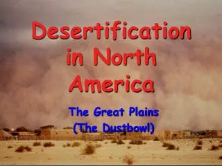
Desertification in North America. The Great Plains (The Dustbowl). Moderate 25 - 75% of topsoil lost. Severe more than 75% of topsoil lost. Background to the Dust Bowl 1.

Desertification in North America
E N D
Presentation Transcript
Desertification in North America The Great Plains (The Dustbowl)
Moderate 25 - 75% of topsoil lost Severe more than 75% of topsoil lost Background to the Dust Bowl 1 Despite more than 50 years of soil conservation practice, soil erosion remains one of the USA’s most severe environmental problems.
Background to the Dust Bowl 2 • About one-third of the cropland in the USA is now suffering a decline in long term productivity which will eventually reduce US exports on food. • The Great Plains (also know as The Dustbowl) is a case study dealing with a major incidence of soil erosion.
The Grasslands Environment Like the African Sahel, the interior grasslands of North America cover an immense area. They extend nearly 4000km from Texas in the south to Alberta in the north at least 800km from east to west.
Vegetation • The grasslands are limited by deserts in the south and coniferous forests in the north. • The area is covered by various species of grass e.g. buffalo grass and needle grass. • Along rivers, trees such as willow and cottonwood can grow in the wetter soils.
Climate 1 • This ranges from sub-humid in the east to semi-arid in the west. • Annual rainfall varies between 350-750mm over the whole area, but occurs mostly during the summer. • Summer temperatures over 30ºC are common often resulting in a moisture deficit between June and September.
Climate 2 • Winter temps range from 10ºC in the south to -10ºC in the north. • Late winter and early spring is when soil moisture has a chance to recharge from the soil melt.
Soil 1 - East • Vegetation and soil are strongly influenced by moisture availability. • Higher moisture availability allows taller grasses to grow (up to 2m). Being short-lived this allows large amounts of organic debris to accumulate. • This material quickly turns into humus and provides both nutrition for the plants and cohesion for the soil.
Soil 2 - West • By contrast, the west is characterised by shorter grass species therefore less organic material is produced making the humus layer shallow and more suitable for ranching.
Physical Causes of Soil Erosion Relief SandySoils Climate Vegetation
Human Causes of Soil Erosion Overcultivation Monoculture
The Dust Storm’s of the 1930’s http://www.youtube.com/watch?v=csnY0Tnvdj8 NOTE DOWN ANYTHING THAT YOU NOTICE FROM THE VIDEO
Poor visibility People struggling to stand up (using the fence to get along) Things blowing everywhere Massive clouds of dust Dangerous driving conditions Large build up (dunes) of soil & dust Houses covered in soil & dust What did you spot in the video?
How did the Dust Bowl Occur? • Events took a serious turn for the worse in 1915. • Until then Russia was America’s major rival as a wheat exporter. • BUT Russia’s output was interrupted by World War I. • The world price for wheat went up by 210% between 1914 and 1917. • Many American farmers made large profits from producing the hard wheat which the world needed for bread making.
How did the Dust Bowl Occur? • In 1931 another cycle of drought occurred. • By the spring of 1934, the plains surface had become so dry that wind storms were able to carry gigantic clouds of soil particles right across the eastern half of the United States. • Large areas of Kansas, Oklahoma, Texas, Colorado and New Mexico were devastated by topsoil loss during the years 1932-36.
What Happened Next? • Hundreds and thousands of rural dwellers abandoned the grasslands. • A large proportion of these came from western Oklahoma, but migrants left every state on the plains. • They moved to the Pacific coast and to the industrial cities of the north-east. • While most managed to sell there farms, a large minority simply gave up there family land.
Dust Storm Management • The Dust bowl catastrophe of the 1930s led the USA Government to establish the Soil Conservation Service (SCS). • The main aim of the SCS is to ensure that, as far as possible, soil is not lost. • Over the years it has adopted a number of strategies to help achieve this.
Shelter Belts • Trees planted to act as windbreaks to protect crops. • As well as trees long rooted, drought resistant grasses were also planted. • Protected crops • Anchored the soil • Increase humus content
Irrigation • Drip irrigation is used extensively in dryer areas to help keep soil moist.
Encouraged Snow? • Snow helps insulate soil. • Provides soils with moisture • Stops soil blowing away • Natural snow fences
Changes in agricultural practice • Fallowing- to help retain moisture and restore soil fertility. • Diversification of agriculture - crop rotation instead of monoculture to maintain soil fertility. • Return marginal areasto grass (roots anchor soil).
Contour Strip Cropping • Prevent formation of rills and gullies by rainwater. • Different crops often planted in strips - harvested at different times - helps protect the soil.
Task Read p.93-96 Add summary notes on Laser levelling, Minimum Tillage, cell grazing, bison ranching.
Groundwater Mining 1 • Under the great plains is a vast geological formation called the Ogallala aquifer, where valuable water is stored naturally. • During the Dust bowl disaster pumping equipment was not widely available to allow farmers to exploit sources of deep, underground water.
Groundwater Mining 2 • By the late 1940s technological advances gave thousands of farmers access to water supplied through centre pivot sprinklers. • This enabled farmers to grow irrigated corn and wheat in the semi-arid western plains. http://www.youtube.com/watch?v=o7Uwg8BT6qQ
BUT there was a price to pay • To install centre pivot systems many shelter belts had to be destroyed. • Overall withdrawal from the aquifer is about 8 times faster than the rate of recharge. • Estimates suggest the aquifer will be pumped dry by 2020. THE DUST CLOUDS WILL RETURN
Failure of the Soil Conservation Service (SCS) • By 1960 it had become a bureaucratic organisation with soil conservation becoming less of a national priority. • But in 1970 soil losses once more became a key issue due to 3 major trends; 1. Great Plains farming had become fully industrialised with short-term profit being seen as more important than maintenance of soil quality.
Failure of the Soil Conservation Service (SCS) • 2. Good quality farmland was being lost to other uses e.g. suburban sprawl, new roads, refuse dumps and open-cast mining. Equivalent to 2000ha per day. • 3. Due to the vast surpluses of grain being accumulated the USA Government paid farmers to keep their land out of production.
http://www.youtube.com/watch?v=1UkObwoheS0 ‘surviving the dustbowl’ documentary. (transcript is in the rural land degradation folder)