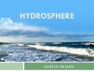
Exploring Regional Watersheds and Divides
Learn about key concepts like drainage basins, divides, and tributaries in regional watersheds, with real-world contexts and tools for water management. Explore the impact of mountain chains like the Great Western Divide on water flow direction. [WORD COUNT: 39]

Exploring Regional Watersheds and Divides
E N D
Presentation Transcript
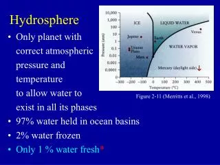
EH. Hydrosphere Benchmark 1 Identify and describe regional watersheds.
Key concepts: • Drainage basins • Divides • ReservoirsTributaries • Run-off
Real-world contexts: Local and regional watersheds Great Lakes Basin Continental Divide
What is a divide? an area of higher elevation that separates watersheds
http://www.gentleye.com/camping/pics/reynolds/e4-Great%20Western%20Divide.jpghttp://www.gentleye.com/camping/pics/reynolds/e4-Great%20Western%20Divide.jpg
Mountain chains determine which direction the water flows. Cascade Mountains Rocky Mountains Appalachian Mountains Sierra Nevada Mountains
Rocky Mountains = Continental Divide All water that falls on the eastern slopes flows into the Atlantic; all water that flows on the western slopes flows into the Pacific.
Tools Maps
Planning water management Evaluating potential disposal sites Analyzing pollution events which concern for both surface and ground water
Resources • http://geography.rutgers.edu/publiclands/lite/media/pix/june7/divide.jpg • http://images.google.com/imgres?imgurl=iowahwypix2.tripod.com/misc/divide.jpg&imgrefurl=http://iowahwypix2.tripod.com/misc/west.html&h=360&w=282&sz=68&tbnid=5NEUAoFcPpwJ:&tbnh=116&tbnw=91&prev=/images%3Fq%3Ddivide%26start%3D40%26hl%3Den%26lr%3D%26ie%3DUTF-8%26oe%3DUTF-8%26sa%3DN • http://images.google.com/imgres?imgurl=www.cco.caltech.edu/~cope/divide.jpg&imgrefurl=http://www.cco.caltech.edu/~cope/photo/divide.html&h=333&w=497&sz=32&tbnid=SEu2sWie3hoJ:&tbnh=85&tbnw=126&prev=/images%3Fq%3Ddivide%26start%3D160%26hl%3Den%26lr%3D%26ie%3DUTF-8%26oe%3DUTF-8%26sa%3DN • http://comnet.org/graphics/orgs/hrwc/shed.gif • http://www.wall-maps.com/wallmaps/usmaps/RavenUS.jpg • http://www.geol.lsu.edu/deltaweb/INDIARPT/MAPS/idrain.gif