Download
1 / 12
120 likes | 347 Vues
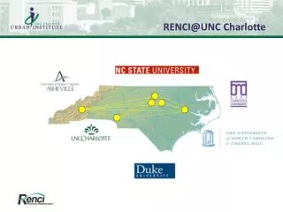
RENCI@UNC Charlotte. RENCI@UNC Charlotte Partners. Focus on Urban Growth measuring, forecasting, and evaluating impacts Partners Center for Applied GIS (CAGIS) - Dr. Ross Meentemeyer Charlotte Visualization Center ( VisCenter ) – Dr. Bill Ribarsky Geography faculty – Dr. Jean-Claude Thill

E N D
RENCI@UNC Charlotte Partners • Focus on Urban Growth • measuring, forecasting, and evaluating impacts • Partners • Center for Applied GIS (CAGIS) - Dr. Ross Meentemeyer • Charlotte Visualization Center (VisCenter) – Dr. Bill Ribarsky • Geography faculty – Dr. Jean-Claude Thill • UNC Charlotte Urban Institute – Jeff Michael
Research Projects • North Carolina Urban Growth Model • Charlotte Land Use & Economic Simulator (CLUES) • Conservation Based Planning in Uwharries (NCWRC) • Urbanization, Forest & Working Lands Study (NSF)
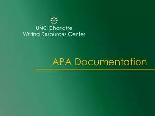
Urban Growth Modeling Landsat Satellite Impervious Surfaces in Charlotte
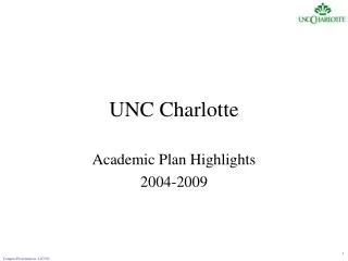
Conservation Based Planning for Uwharries Locations with high development & conservation value
Charlotte Land Use & Economic Simulator (CLUES) • Key Features: Simulates Decisions of Urban Actors Explicit Representation of: • Land, Buildings and Occupants • Land Market and Prices • Businesses and their Employees • Government Policies and Infrastructure
Charlotte Land Use & Economic Simulator (CLUES) • Inputs • Land ownership parcels • Land use plans • Census data • Businesses • Transportation system • Household travel survey • Environmental constraints • Outputs • Households, Employment by type • Real estate development and prices
User Specified Events Real Estate Development Model Location Choice Models Unplaced Jobs and Households External Models User Inputs Transition Models Land Price Model Macroeconomic Model Relocation Models Event Queue DBMS and GIS Policy Assumptions Travel Demand Model System Vacant Real Estate Control Totals Travel Data CLUES Data Store (cached data) Data Models External System