LAKE CHAD’S VARIABILITY
This overview captures the shifting landscapes of significant ecosystems like Lake Chad and the Aral Sea, illustrating the environmental impacts of human activities and climate change. While Lake Chad's surface area fluctuates with seasonal rains and irrigation demands, the Aral Sea's drastic reduction in size highlights severe ecological decline. Additionally, the deforestation in Brazil's Rondonia and Mato Grosso regions showcases the transformation from lush forests to agricultural land, impacting biodiversity and climate. These case studies underline the urgent need for sustainable practices.

LAKE CHAD’S VARIABILITY
E N D
Presentation Transcript
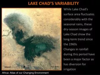
LAKE CHAD’S VARIABILITY While Lake Chad’s surface area fluctuates considerably with the seasonal rains, these dry-season images of Lake Chad show the long-term trend since the 1960s Changes in rainfall during this period have been a major factor as has diversion for irrigation Africa: Atlas of our Changing Environment
Death of a sea ARAL SEA, KAZAKHSTAN Images show death of the world’s fourth largest inland sea • 1973: The surface of the sea once measured 66 100 km2 • 1986: 60% of the volume had been lost • 1999-2004: The sea is now a quarter of the size it was 50 years ago One Planet Many People: Atlas of our Changing Environment
RONDONIA, BRAZIL Converting forests to farmlands • 1975 -Healthy natural vegetation • 1989 - “Fishbone” pattern on the landscape indicates agriculture fields • 2001 - Agriculture continues to replace forest cover One Planet Many People: Atlas of our Changing Environment
MATO GROSSO, BRAZIL Deforestation may be reaching a tipping point 1984/1985: south-west to north-east path cut through the forest in an area of north-central Mato Grosso where highway BR-163 was built in 1973, and another highway branching to the northwest off BR-163 By 2010, the clearing that occurred only along roads in the mid 1980s had spread throughout the entire area leaving only patches of forest UNEP Global Environmental Alert Service
ATHABASCA OIL SANDS, CANADA 1989: Oil sands mining in the Fort McMurray area when the Canadian Govt. began to encourage expansion. The bright areas cut into the boreal forest and muskeg wetlands are mining pits, tailings ponds, production facilities and roads 2009: the footprint had grown dramatically, with active operations spanning over 55 km from north to south UNEP Global Environmental Alert Service