Surveying with the Global Positioning System Code Pseudo-Ranges
Surveying with the Global Positioning System Code Pseudo-Ranges. Outline of Session 1. GPS Fundamentals Types of GPS Positioning Levels of Accuracy Pseudo-Ranges DOPs GLONASS. LORAN (Triangulation) - Continuous position fixes - Accurate to 300 meters - Limited coverage - Lat/Long.

Surveying with the Global Positioning System Code Pseudo-Ranges
E N D
Presentation Transcript
Outline of Session 1 • GPS Fundamentals • Types of GPS Positioning • Levels of Accuracy • Pseudo-Ranges • DOPs • GLONASS
LORAN (Triangulation) - Continuous position fixes - Accurate to 300 meters - Limited coverage - Lat/Long TRANSIT (Doppler Shift) - 16 or less fixes a day - Sub-meter accuracy in about 3 days - Worldwide coverage - Lat/Long/Height Before GPS There Was...
LORAN (Triangulation) - Continuous position fixes - Accurate to 300 meters - Limited coverage - Lat/Long TRANSIT (Doppler Shift) - 16 or less fixes a day - Sub-meter accuracy in about 3 days - Worldwide coverage - Lat/Long/Height GPS - Continuous position fixes - Worldwide coverage - Lat/Long/Height - Centimeter accuracy in seconds ...Now
What is GPS? • A super accurate system • Developed and maintained by US Department of Defense • Satellite-based • Sold US Congress on the idea that other applications would follow • Signals are free • Unlimited users
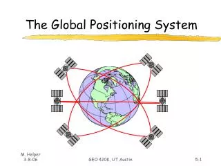
Space Segment 4 Monitor Stations and one Master Control Station User Segment Control Segment 3 Segments of GPS
GPS Satellite Constellation • 24 Satellites • 6 orbital planes • 20,000 km high • 12 hour orbits • At least 4 Satellites in view 24 hours per day • Any weather
The GPS Satellite • 3 atomic clocks • L Band Radio Signals - 19 -24 cm Wavelength • Codes on the signal • Distance to SV by time signal takes to reach the receiver or other method • Satellite Position • Also give health of system
3 Types of GPS Positioning • Point Positioning • Differential GPS • GPS Surveying
3 Levels of GPS Accuracy • Point Positioning - 100m 95% of the Time for Civilian Users - With SA • About 10-20m without SA • Differential GPS - 0.5m to 10m • GPS Surveying - 5mm per km typical and centimetres in thousands of km possible • Surveyors can and should be involved in all 3 levels
R3 R4 R2 Satellites are saying My Time is … My Position is ... R1 1 Receiver - “Point Positioning” • Basic technique for which GPS was designed • Basic Civilian Receivers < $ 500
3 4 4 SVs to solve for X,Y,Z,t Use message from satellite for its location 2 Distance from satellites (SV) using speed of light 5 Correct for Troposphere & Ionosphere 1 Based on Trilateration Code Range GPS in 5 Steps
1 Trilateration From Satellites • By measuring distance from several satellites you can calculate your position
20,000 Km Trilateration • Assume for now we can measure a distance to a SV • One measurement narrows down our position to the surface of a sphere We're somewhere on the surface of this sphere.
Trilateration • Second measurement narrows it down to intersection of two spheres Intersection of two Spheres is a circle
Trilateration • Third measurement narrows to just two points
Trilateration • In theory 3 measurements are enough because • We can discard one point because it will be a ridiculous answer • Out in space • Or moving at high speed • But we do need the 4th measurement to cancel out clock errors
Trilateration 4 Ranges to resolve for Latitude, Longitude, Height & Time It is similar in principle to a resection problem
2 Satellite Ranging • Measuring the distance from a satellite • Done by measuring travel time of radio signals
Speed-of-Light Measurement • Measure how long it takes the GPS signal to get to us • Multiply that time by 300,000 km/sec • Time (sec) x 300,000 = km • If you've got a good clock in the receiver, all you need to know is exactly when signal left satellite
Xll lX l X ll lll Xl lV Vlll Vll V Vl Outline Principle : Range
Xll lX l X ll lll Xl lV Vlll Vll V Vl Outline Principle : Range
Xll lX l X ll lll Xl lV Vlll Vll V Vl Outline Principle : Range
Xll lX l X ll lll Xl lV Vlll Vll V Vl Outline Principle : Range Range = Time Taken x Speed of Light R = Dt x c
measure time difference between same part of code from satellite from ground receiver How Do We Know When the Signal Left the Satellite? • One of the Clever Ideas of GPS: • Use same code at receiver and satellite • Synchronize satellites and receivers so they're generating same code at same time • Then we look at the incoming code from the satellite and see how long ago our receiver generated the same code
3 Accurate Clocks • Whole system depends on very accurate clocks • Necessary to measure travel time • Ensures receiver and satellite are synchronized • Satellites have atomic clocks • Accurate but expensive • Ground receivers need consistent clocks • Secret is in extra satellite measurement that adjusts receiver clock
4 Knowing Where the Satellites Are • 20,000 km up - high orbit • Very stable orbits • No atmospheric drag • Survivability • Earth coverage • Monitored by US Defense Department • DOD transmits corrections back to satellite • Corrections transmitted from satellites to us • Status message
Space Segment Current ephemeris is transmitted to users • Monitor stations • Diego Garcia • Ascension Island • Kwajalein • Hawaii GPS Control Colorado Springs Knowing Where the Satellites Are - Ephemeris
Ionosphere Troposphere 5 Atmospheric Corrections • Apply estimated corrections • The signals are delayed by the ionosphere and troposphere • Receiver makes estimated corrections for these delays
Dilution of Precision (DOP) • A measure of Satellite geometry • Indicates the quality of position fix • Can be expressed in different dimensions • for example: PDOP, HDOP, VDOP, TDOP • PDOP less than 6 is best
4 sec 6 sec Dilution of Precision (DOP) • Relative position of satellites can affect error idealized situation
6 ‘ish sec 4 ‘ish sec uncertainty uncertainty Dilution of Precision (DOP) • Real situation - fuzzy circles Point representing position is really a box
Dilution of Precision (DOP) • Even worse at some • angles Area of uncertainty becomes larger as satellites get closer together
Selective Availability “SA” • Military Users - Precise Positioning Service (PPS) • +/- 15m for Military Users • Uses P Code which has high resolution • Good accuracy Satellite Positions (Ephemeris) • Civilian Users - Standard Positioning Service (SPS) • +/- 100m 95% of the time (+/- 150m vertical) SA on • +/- 10-20m 95% of the time SA off • C/A code 10 times less resolution than P code • Ephemeris accuracy deliberately downgraded • Future of SA? • Now turned off - Presidential Directive • For how long?
GLONASS Russian Federation’s GLObal NAvigation Satellite System First launch Oct 1982 • Uses 3 orbital planes rather than 6 with GPS • GPS - same frequency but different codesGLONASS - same code, different frequency • Channel of Standard Accuracy (CSA) 60m horizontal, 75m vertical (99.7% confidence) • Restricted access to Channel of High Accuracy (CHA) • Gallelio emerging
GLONASS • Receivers with both GPS and GLONASS • More satellites available = more robust solution • Can work despite significant satellite obstruction • Advantages for surveying; especially for techniques which use minimal observation time • 2 significant system level issues: • different timing systems used • different underlying geodetic reference systems, WGS84 for GPS vs PZ90 for GLONASS. • IGEX98 - observe both systems around the world using geodetic quality equipment • Station at DNR’s Landcentre in Brisbane
Conclusion to Session 1 • GPS Fundamentals • Types of GPS Positioning • Levels of Accuracy • Pseudo-Ranges • DOPs • GLONASS