Download
1 / 40
400 likes | 650 Vues
Watershed Planning Tools and an Integrated Watershed Approach. Stuart Lehman U.S. EPA NPS Control Branch. January 19, 2007 Bordentown, NJ. CWA Watershed Framework. Water Quality Standards Use Attainability Analysis. Monitor/Assess WQS Attainment Assessment methodology 305(b) Report

E N D
Watershed Planning Tools and an Integrated Watershed Approach Stuart Lehman U.S. EPA NPS Control Branch January 19, 2007 Bordentown, NJ
CWA Watershed Framework Water Quality Standards Use Attainability Analysis Monitor/Assess WQS Attainment Assessment methodology 305(b) Report 303(d) List of Impaired Waters EPA approves 303(d) list Continuing Planning Process(CPP) TMDL WLAs to individual point sources LAs to nonpoint sources EPA approval Watershed Plan State developed or approved NPDES permits for point sources EPA discretion to object Manage nonpoint sources w/ Federal/State $
Integrated Watershed Management CZA 6217
Watershed Mgmt. & Typical Roles Assess Plan Impment Monitor State NPS Mgmt Plans / grants / NPDES/TMDLs Monitoring – projects & statewide/ WQstds Growth Mgmt Policies – build out? Env. Assess. Watershed Progs, funds & T. Assist. (incl 319) Federal EPA – WQ crit. & MCLs, 319, TMDLs USDA – Farm Plans, Local Ctrl, EQIP, etc USFS – Multiple- use/NEPA/ ESA/Hydrol. FWS – ESA habitat & other habs Local Land use/ zoning / codes/ ordinances Septic regs Watershed Plans Stormwater permits USDA committees
NINE Elements of Watershed-based Plans that include Nonpoint Source Pollution A. Identification of causes and sources, listed waters, pollutants, loads by watershed sub-categories, (crops, AFOs, urban, forestry, etc.) B. Estimate of load reductions by land use (or other) subcategories expected from BMPs C. Description of BMPs, How they are targeted (map suggested) D. Estimate of needed technical & financial resources E. Information/ Education component F. Schedule (who does what, when) G. Description of measurable milestones for implementation H. Criteria to determine if loadings/ targets are being achieved I. Monitoring component for above criteria
Watershed Planning Steps STEP 1 BUILD PARTNERSHIPS • ID stakeholders • ID issues of concern • Set preliminary goals • Develop indicators • Conduct outreach
Watershed Planning Steps STEP 1 BUILD PARTNERSHIPS • ID stakeholders • ID issues of concern • Set preliminary goals • Develop indicators • Conduct outreach STEP 2 CHARACTERIZE WATERSHED • Gather existing data • Create data inventory • ID data gaps • Collect additional data, if needed • Analyze data • ID causes and sources • Estimate pollutant loads
Watershed Planning Steps STEP 1 BUILD PARTNERSHIPS • ID stakeholders • ID issues of concern • Set preliminary goals • Develop indicators • Conduct outreach STEP 3 FINALIZE GOALS AND ID SOLUTIONS • Set goals and management objectives • Develop indicators/targets • Determine load reductions needed • ID critical areas • ID management measures needed STEP 2 CHARACTERIZE WATERSHED • Gather existing data • Create data inventory • ID data gaps • Collect additional data, if needed • Analyze data • ID causes and sources • Estimate pollutant loads
k Watershed Planning Steps STEP 1 BUILD PARTNERSHIPS • ID stakeholders • ID issues of concern • Set preliminary goals • Develop indicators • Conduct outreach STEP 4 DESIGN IMPLEMENTATION PROGRAM • Develop Implementation schedule • Set Interim milestones • Determine how you will measure success • Develop monitoring component • Develop evaluation process • ID technical and financial assistance needed • Assign responsibility STEP 3 FINALIZE GOALS AND ID SOLUTIONS • Set goals and management objectives • Develop indicators/targets • Determine load reductions needed • ID critical areas • ID management measures needed STEP 2 CHARACTERIZE WATERSHED • Gather existing data • Create data inventory • ID data gaps • Collect additional data, if needed • Analyze data • ID causes and sources • Estimate pollutant loads
k Watershed Planning Steps STEP 1 BUILD PARTNERSHIPS • ID stakeholders • ID issues of concern • Set preliminary goals • Develop indicators • Conduct outreach STEP 5 IMPLEMENT WATERSHED PLAN • Implement management strategies • Conduct monitoring • Conduct I/E activities STEP 4 DESIGN IMPLEMENTATION PROGRAM • Develop Implementation schedule • Set Interim milestones • Determine how you will measure success • Develop monitoring component • Develop evaluation process • ID technical and financial assistance needed • Assign responsibility STEP 3 FINALIZE GOALS AND ID SOLUTIONS • Set goals and management objectives • Develop indicators/targets • Determine load reductions needed • ID critical areas • ID management measures needed STEP 2 CHARACTERIZE WATERSHED • Gather existing data • Create data inventory • ID data gaps • Collect additional data, if needed • Analyze data • ID causes and sources • Estimate pollutant loads
k Watershed Planning Steps STEP 1 BUILD PARTNERSHIPS • ID stakeholders • ID issues of concern • Set preliminary goals • Develop indicators • Conduct outreach STEP 6 MEASURE PROGRESS AND MAKE ADJUSTMENTS • Review and evaluate information • Share results • Prepare annual plans • Make adjustments to program STEP 5 IMPLEMENT WATERSHED PLAN • Implement management strategies • Conduct monitoring • Conduct I/E activities STEP 4 DESIGN IMPLEMENTATION PROGRAM • Develop Implementation schedule • Set Interim milestones • Determine how you will measure success • Develop monitoring component • Develop evaluation process • ID technical and financial assistance needed • Assign responsibility STEP 3 FINALIZE GOALS AND ID SOLUTIONS • Set goals and management objectives • Develop indicators/targets • Determine load reductions needed • ID critical areas • ID management measures needed STEP 2 CHARACTERIZE WATERSHED • Gather existing data • Create data inventory • ID data gaps • Collect additional data, if needed • Analyze data • ID causes and sources • Estimate pollutant loads
Capacity Building • CB Strategy • Funding catalog - & New Sustainable Funding web site - Cross Office Team • Smart Growth web site –Cross Office Team • Watershed Academy – online courses • Monthly Web casts – wetlands, drinking water, Smart Growth • New Watershed Tools training • Watershed Handbook Training
Capacity Building Grants Targeted Watersheds Funds • $1.6 -3.2 Million for FY2006/07 • Geographic Focus Areas • (Arid West, Great Plains, Appalachia) • Up to 20% can be go to Mini-grants • Targeted Watershed Grants • … in addition to NEPs • … in addition to NPS 319
On the Technical Side • Watershed Handbook being updated • Working with grantees to develop technical tools • AGNPS with CONCEPTS (bank erosion element) • VA Tech • SWAT AG BMP Optimization (Auburn CES) • AV-GWLF Penn State model being applied to New England • Watersheds and Wetland Protection Guides • “Plan Builder” On-Line Tool • “Watershed Central”
Technical Analysis Challenges in Planning addressed by our Handbook • GIS and geographic data • Statistical interpretation of data • Modeling and Spreadsheet tools • Defining the pollution reductions from BMPs for Nonpoint Sources • Setting up a monitoring program • Evaluating changes due to management
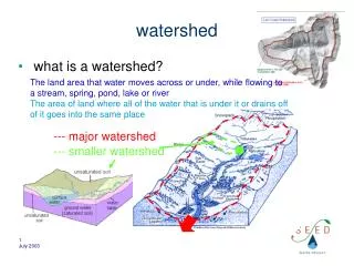
Identification of causes and sources, listed waters, pollutants, loads by watershed sub-categories, (crops, AFOs, urban, forestry, etc.) • Tools: • NEMO land use assessments • Watershed Model s– • SWAT / GWLF/ L-thia • BASINS, AGWA, CADDIS • WRAP • State GIS Clearinghouses
B. Estimate of load reductions by land use (or other) subcategory expected from BMPs • Tools • Watershed models that incorporate BMPs • AGWA • GeoWEPP • BMP Research • WCS - R4
Description of BMPs and how they are targeted (we suggest a map). • Tools • BMP targeting • (Penn State tool set) • PreDICT • NPS Tool • AvGWLF Wisconsin Buffer Targeting Models USLE + “Snap-Plus”
D. Estimate of needed technical & financial resources • Tools • Env Finance Centers - MD, BSU, others • EPA Funding Web Site • Catalog of Federal Funding EPA Watershed Funding Site Sustainable Finance Team
E. Information/ Education component • Tools: • Getting in Step • Adopt Your Watershed • Adopt Your Waterway • NPS Outreach Tool Box
F. Schedule (who does what, when) • Tools : • Plan2Fund • State guides • EPA Watershed Approach Guides State and Local
G. Description of measurable milestones for implementation • Tools: • Plan2Fund • 319 Project work plans • Describes what is to be done, by whom, and when – interim “beans.”
H. Criteria to determine if loadings/ targets are being achieved • Tools: • CADDIS (EPA) • Rapid Bio-assessment Protocols • State WQStds and Assessment Methods • Wadeable streams, lakes, rivers studies
I. Monitoring component for above criteria • Tools: • Citizen Monitoring Guidance • LaMotte Chemical Company Monitoring Guides • EPA Volunteer Monitoring News • National NPS Monitoring Program Case Studies • State Cooperative Extensions • State 303(d) Assessment Guidelines • Stream Corridor Guide
Incorporation Wetlands into Watershed Planning Process (CWP) / EPA Project
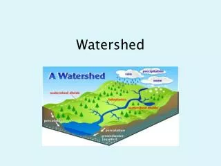
Section of Annotated Outline 3.1.3 Climate/Precipitation Provide current and historic climate data for your watershed. Climate data provides information that is critical in evaluating the hydrology of an area. Information about temperature, rainfall, snowfall, and evapotranspiration, is used to simulate rainfall-runoff processes in watershed models. Local climatological data helps one to better understand the local water budget for the region and also helps for modeling purposes. 3.1.5 Surface Water Resources Identify all surface water features in the watershed. Surface water includes all water that is naturally open to the atmosphere, such as lakes, rivers, seas and reservoirs. In addition to being an important source of drinking water and recreation, these waters are also vital parts of local and regional ecosystems. Surface water pollution can result from a number of sources, including dredging, stormwater runoff, ocean dumping and industrial wastewater discharges. Your state Department of Environmental Quality can provide useful information on surface water, data inventory, maps and related issues.
Search: GO